• Our booking engine at tickets.railforums.co.uk (powered by TrainSplit) helps support the running of the forum with every ticket purchase! Find out more and ask any questions/give us feedback in this thread!

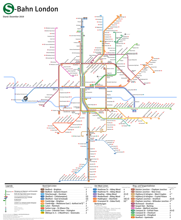
[Map] Overground, Crossrail and Thameslink as an S-Bahn system

Status
Not open for further replies.

Mutant Lemming

Established Member
Joined
8 Aug 2011
Messages
3,194
Location
London
The phrase or concept of "the circle line" may be known worldwide, but perhaps not its route. Tourists for the most part aren't looking for "the circle line", they're after the destination on the front end of a train, and if they're okay with looking for the word "Cockfosters" they're going to be okay with looking for the number "C5".

Cockfosters, Upminster, Amersham - they mean something. C5 is a meaningless number. If you like a sterile meaningless world fine but I prefer some local identity to transport systems instead of a bland, faceless, if efficient, teutonic style.
S4 Frankfurt, S4 Hamburg, S4 Munich - it might all be efficient and easy to use etc blah blah blah but it's downright dull and ultra boring
Give me Кольцева́я ли́ния, Bakerloo Line or something with local meaning to some sterile number any day. Keep your numbers for the bus routes. As for Thameslink - I'm quite happy with that as a name. Give it a number and I'll ignore it and still call it Thameslink.
 
Sponsor Post - registered members do not see these adverts; click here to register, or click here to log in
R

RailUK Forums

Loki

Member
Joined
24 May 2013
Messages
151
Location
West Midlands
I've been suggesting this for years. There are many examples where this will help but Metro style services such as the LO are a perfect example. I don't understand for the life of me why are some operators so hell-bent on pretending multiple lines are just one by colouring them with the same colour and using the same name!
 

Mutant Lemming

Established Member
Joined
8 Aug 2011
Messages
3,194
Location
London
I'm not obsessed with German, just think European networks as a whole work much better than our own, and it is not because of NATIONALISATION before anyone goes off on that.

The current system clearly does NOT work for everyone. If a tourist came to London, they'd struggle with it, especially if they were trying to get from Heathrow to Clapham or somewhere which involves Overground.

I get fed up with this notion " just think European networks as a whole work much better than our own" - though there are issues with our transport systems they are by no means the poor relation to our European cousins. Considering how little we fund our railways they actually do a very good job. I have been a vociferous critic of my local line but it has vastly improved recently. Comparing it to France - if you aren't going to/from Paris services are pretty dire - try going from Lille to Lens - third largest conurbation in France, the Paris metro is more dangerous and crime ridden than the London underground. German railways are plagued by graffiti in urban areas and their main stations are not the nicest of environments at night- crime is a much more serious problem there than here. We do have our problems here undoubtedly but I just get fed up of the rose tinted view people have of "ultra-efficient" transport networks elsewhere.
 

jhy44

Member
Joined
7 Aug 2008
Messages
187
Location
Bromsgrove (Worcestershire)
(Click image for a version with a higher resolution)

P.S.: In an earlier version of the map, the route of the river Thames was incorrectly shown; I have now updated this now, but it might take a while until the most recent version of the graphic appears.

This is absolutely wonderful!

It really frustrates me how complicated and unclear London transport is (except for the Tube map), you've done a wonderful job here and I think TfL should definitely implement such a map.

The only things I would suggest that could perhaps improve it (of course, they could look terrible in reality!) might be:

- Use a more accurate shape for the River, it's such a unique shape that it really is the basis for reading any map of London, having Canary Wharf station not atop an Isle of Dogs shaped kink in the river will throw a lot of people (myself included).

- Maybe try and find a way to include some more non-TfL run mainline services? I know as you said this might be too messy/complicated, but it would be wonderful to try and get some in, especially in South London, I don't think it would be too complicated to include the Southeastern lines to Dartford (Greenwich/Bexleyheath/Sidcup) for example, they're relatively straightforward:

Southeastern could have an 'E' prefix,
Southern an 'S' prefix.
and South Western Railway a 'W' prefix for example.

Once again, amazing work! Bravo!
(please ignore people who complain that it's 'cold' or 'sterile', people also said the same about Decimalised currency but they soon got over it, the British have a terrible habit for resisting any change including when it's for the better).
 

Mutant Lemming

Established Member
Joined
8 Aug 2011
Messages
3,194
Location
London
(please ignore people who complain that it's 'cold' or 'sterile', people also said the same about Decimalised currency but they soon got over it, the British have a terrible habit for resisting any change including when it's for the better).
So you'd prefer a depersonalised number to a more characterful name ? Have no problem with the map just ditch the numbers for names.
As for decimalised currency anyone around at the time will tell you that the pound used to worth something BEFORE decimalised currency and it was one of the biggest rip offs the nation had to endure leading to rampant inflation. Having to work out differing multiples of 12, 20 and 40 made people more mathematically sharper. Now people can't add up without the aid of some device to do it for them. Might be a plus for people who prefer a dumbed down society.
 
Last edited:

Domh245

Established Member
Joined
6 Apr 2013
Messages
8,426
Location
nowhere
So you'd prefer a depersonalised number to a more characterful name ? Have no problem with the map just ditch the numbers for names.

Well then, all you've got to do is come up with 30 different line names to replace the numbers on the map in the OP. Ideally, they'd indicate any services that run together (ie all of the crossrail routes should all have similar but distinctive names). And obviously whilst they need to be characterful, they should all be succinct and easy to understand. And once you've sorted that out, you can also start thinking about names for all the other suburban rail services around London just in case they also get added to the map.
 

davetheguard

Established Member
Joined
10 Apr 2013
Messages
1,811
Absolutely excellent map.

Not my local patch, but I'm sure Manchester could do with your talents; the latest Manchester Metrolink tram map is very poor unless you know the local geography.
 
Joined
7 Jan 2009
Messages
864
Very good! I can now see how the TL service patterns are intended to work but I expect there will have to be a further edition to revise the patterns in the light of experience....
 

Roast Veg

Established Member
Joined
28 Oct 2016
Messages
2,202
I appreciate that this is maybe going off-topic but when did the old Southern Region services drop the two digit route numbers that they used to show on the front windows?
Until the stock that carried them was withdrawn, so not even 15 years ago.
 

PreciousPasta

Member
Joined
30 Oct 2016
Messages
9
Firstly I wanted to say that it's a great looking map - my only complaint is that my local station of Upper Holloway on the good ol' GOBLIN has been left out!
So you'd prefer a depersonalised number to a more characterful name ? Have no problem with the map just ditch the numbers for names.
As for decimalised currency anyone around at the time will tell you that the pound used to worth something BEFORE decimalised currency and it was one of the biggest rip offs the nation had to endure leading to rampant inflation. Having to work out differing multiples of 12, 20 and 40 made people more mathematically sharper. Now people can't add up without the aid of some device to do it for them. Might be a plus for people who prefer a dumbed down society.
The idea that decimalisation was the reason for inflation or for the decline in value of the pound is deeply misguided, as is thinking that it was responsible for a decline in mental maths ability. All that pre-decriminalisation currency did was waste years of time teaching schoolchildren to juggle with a nonsensical, non-standardised system rather than spending time learning other things.
You may disagree with having numbers for lines, but evidently there are plenty of people who, like myself, think that it would simplify what is a very complex and confusing system. It's obviously a matter of personal choice, and so slinging about 'but I think that numbers are bad!' is pointless. Even if numbers were to be introduced I'm sure you could still refer to lines by their names and people would understand what you were talking about.
 

AverageTD

Member
Joined
13 Aug 2017
Messages
266
Location
West London
The map is clear and unlike the current tube map it seems spacious. I visited Berlin last year and the map was so clear to learn. It would help tourists to have a number or letter as its easier to understand than a longer name but it’s nice to see Thameslink included as its almost forgotten by non railway fans or people who live on the line (or that’s the feedback I’ve gotten). It’s a very useful line for tourists in London as Brighton is day trippable
 

coppercapped

Established Member
Joined
13 Sep 2015
Messages
3,099
Location
Reading
Cockfosters, Upminster, Amersham - they mean something.
Only if you know the geography of the area and also are familiar with the way railways organise and route their trains.

C5 is a meaningless number. If you like a sterile meaningless world fine but I prefer some local identity to transport systems instead of a bland, faceless, if efficient, teutonic style.
S4 Frankfurt, S4 Hamburg, S4 Munich - it might all be efficient and easy to use etc blah blah blah but it's downright dull and ultra boring
Give me Кольцева́я ли́ния, Bakerloo Line or something with local meaning to some sterile number any day. Keep your numbers for the bus routes. As for Thameslink - I'm quite happy with that as a name. Give it a number and I'll ignore it and still call it Thameslink.

You can do what you like. Others find route codes helpful - don't use them if you don't need them.
 

DenmarkRail

Member
Joined
13 Jun 2016
Messages
665
Sure, names are cool, but I'd rather be able to understand something, than have fancy names.
 

CeeJ

Member
Joined
25 Jun 2017
Messages
157
Absolutely love it – would be incredibly useful, especially if there was a significant LO expansion in the SE/SW/SC metro services.

My only suggestion would be that, instead of using a '5' to denote sister/branch services, adopting the good old extra-letter that is used on buses. So instead of C1 and C15, it'd be C1 (Terminal 4-Abbey Wood) and C1A (Terminal 5-Abbey Wood).
 

43021HST

Established Member
Joined
11 Sep 2008
Messages
1,564
Location
Aldershot, Hampshire
Give me Кольцева́я ли́ния, Bakerloo Line or something with local meaning to some sterile number any day. Keep your numbers for the bus routes. As for Thameslink - I'm quite happy with that as a name. Give it a number and I'll ignore it and still call it Thameslink.

"Local Lines for local people, there's no room for intuitiveness and ease of use here"
 

Bletchleyite

Veteran Member
Joined
20 Oct 2014
Messages
97,841
Location
"Marston Vale mafia"
"Local Lines for local people, there's no room for intuitiveness and ease of use here"

No reason you can’t have the U1 still known by locals as the Walddoerferbahn or the U3 the Ringlinie, as indeed it is in Hamburg. No harm in having it on the map any more than the EN421 (I think) being called the Donauwalzer.
 

TTA

Member
Joined
4 Jul 2017
Messages
14
I like this map concept. I really dislike how 'overground' lines don't have any sort of designation, especially when looking at the now text only planned engineering works, so giving them numbers makes real sense.
 

BluePenguin

On Moderation
Joined
26 Sep 2016
Messages
1,605
Location
Kent
It looks great! I feel that Clapham Junction is in wrong place. It should be slightly north of East Croydon. I had a little bit of trouble finding the East Croydon - Watford/Milton Keynes route as it doesn't have its own line.

Also, ar the moment it is only shown as being a station on the Overground. Adding a different coloured line from it to Watford Junction would be nice.

I see this map avoids London Terminals where possible which I imagine is why Victoria is missing and how Gatwick Express, Orpington, Ashford and a few Southern services are all shown as going into the Thameslink core - which they do but not all of the time.

Could I also suggest adding a line from St Pancras to Stratford as a mild reference to HS1?

Overall it is very good and I really like how easy it is to read because of the different colours.
 
Last edited:

GatwickDepress

Established Member
Joined
14 Jan 2013
Messages
2,288
Location
Leeds
I'm not a tremendous fan of this, despite its great effort and clarity in separating routes, I find parts of it quite confusing - such as London Bridge seeming immediately north of East Croydon. The current London Tube and Rail map is somewhat hard to digest, but when I was travelling around London with some American friends last month, they found the completeness of the map quite helpful.

I really don't want to sound like I'm disparaging your efforts, because it is beautifully made. I can see a S-Bahn route map being used officially if a combined TfL Rail/London Overground one was made, but the current map as it is wouldn't be too helpful for passengers with the massive overlap between services and lines London has.
 

Mutant Lemming

Established Member
Joined
8 Aug 2011
Messages
3,194
Location
London
Sure, names are cool, but I'd rather be able to understand something, than have fancy names.

Er sorry I don't get it - you mean 46, 27, 15 , 12 S4 B2 E37 etc... is easier to understand than the Cotswold Line or the Chiltern Line or the Dartford Loop or Sutton Loop ?
 

Domh245

Established Member
Joined
6 Apr 2013
Messages
8,426
Location
nowhere
Er sorry I don't get it - you mean 46, 27, 15 , 12 S4 B2 E37 etc... is easier to understand than the Cotswold Line or the Chiltern Line or the Dartford Loop or Sutton Loop ?

Well obviously at the moment, the former are a load of gibberish and the latter are reasonably well recognised, but there is no reason why that shouldn't change.

I would however point out that a) All of those names are geographically based - try applying the same to something like Crossrail where there are a number of interworking branches and services, and b) They're all only named after a particular location - all well and good describing something as the Sutton loop line, but it's completely irrelevant to anyone going from St Albans to West Hampstead.
 

U-Bahnfreund

Member
Joined
6 Feb 2015
Messages
370
Location
Germany
I have now updated the minor mistakes on the map that some of have pointed out, you can find the latest version here: https://upload.wikimedia.org/wikipedia/commons/4/4d/Netzplan_S-Bahn_London_2019.png.

But from the discussion, I gather (and I also knew myself) that this is not the perfect map to depict the London suburban railways. I have a new map in mind, that I am currently researching the timetables for, that will hopefully be (even) better.

My notes on the line numbers thing: I know that there are also names for the railway lines that are very dear to the locals, but considering that London is one of the most visited city worldwide (usually in the top 3 with Paris and Bangkok) and the complexity of its railways, I think that suggesting better and more logical designations for the different lines and services is not a bad idea. As the others have pointed out, local names do not have to vanish with the introducing line numbers. The regional train services in the German state I live in, even got new names when numbers were introduced. For example, the service operated by National Express that runs from my city to Cologne has the line number RE7 and is also called Rhein-Münsterland-Express. The New York City Subway has had letters and numbers for their services for ages, but still, the line that the 4, 5 and 6 services run on is known as the (IRT) Lexington Avenue Line, and services A, C and E all use the (IND) Eighth Avenue Line. Berlin’s services S41 and S42 are the Ringbahn, the S1 runs partly on the Wannseebahn; the Cologne to Bonn interurban trams are still known as the Rheinuferbahn (16) and Voreifelbahn (18), etc. There are many example where urban rail system have both a number or letter system and local names.

By the way, the Кольцевая линия someone mentioned, is also known as line 5, as seen on this map: http://mosmetro.ru/download/s.jpg I think it would be quite hard for people to remember names like Серпуховско-Тимирязевская линия (do you know how to pronounce this?) when they just want to know which metro lines takes them from the city centre to, say, Savyolovsky railway terminus.

Also, happy new year to everyone! :)
 

HowardGWR

Established Member
Joined
30 Jan 2013
Messages
4,983
Like the latest one even better. I note from my visits to Berlin, that S-bahn services stretch quite far out of Berlin, so one to Gatwick (but Brighton?) is perhaps not so daft. It has more to do with the nature of the service (S for suburban in British thinking) than the length of line. How does one reconcile this concept with German RB RE lines though? I'm thinking about Cottbus, for example, comparing with Brighton? I travelled from Lubbenau (on the line from Cottbus) to Berlin and IIRC, the S bahn services only started as far out as Konigs Wusterhausen. That's only approx. 35 kms from the centre of Berlin.
 

Peter Mugridge

Veteran Member
Joined
8 Apr 2010
Messages
14,825
Location
Epsom
A point on the new one; I see you've amended the Sutton loop arrows after someone pointed out the issue with the original version, but surely as all three arrows are now double ended then you might as well remove them altogether?
 

zuriblue

Member
Joined
12 Oct 2014
Messages
536
Location
Baden Switzerland
S-Bahn and RER are both brandings of city train services so they could be considered synonyms. Brussels is in the process of upgrading its suburban rail, and has labelled the lines with an S prefix like Germany and Switzerland. However, the network is referred to as "Réseau Express Régional Bruxellois" in French.

In fact in Switzerland the S-bahn systems in the German speaking parts are S-bahn but the S-bahn systems in the French speaking part around Lausanne and Geneva are called RER. But the train route numbers are still prefixed S.
 

sbec4

Member
Joined
11 Mar 2012
Messages
7
Location
Dover Kent
I really like the map and concept - well done for a lot of hard work. Not sure why but I wonder if the number could not be approximated to the A round numbers closest to. For example '2' toward Kent, '3' toward Surrey, '4; to the West and '1' to the North. It might just mean that there is another relationship and association? Just a thought?
 

DelW

Established Member
Joined
15 Jan 2015
Messages
3,872
Until the stock that carried them was withdrawn, so not even 15 years ago.
They're still on the route blinds of SWR's 455s.

Personally I think it's a pity they were dropped, they were useful on routes with multiple calling patterns.
 

HSTEd

Veteran Member
Joined
14 Jul 2011
Messages
16,722
Why is it an either/or for route names and numbers?

Why can't the train display "T3 - Bedford" or something?

Most succesful mass transit systems use numbers rather than names, see the New York City Subway as the obvious example.
Ideally you would have a seperate number for every single possible stopping pattern in use, grouped in a logical manner (both wtih similar prefixes and with similar numbers, so T1x [T10-T19] would have something in common.
 
Status
Not open for further replies.

Top