Peter Mugridge
Veteran Member
Could just change all the line names to letters or numbers such as many systems around the world have.
That is a very good idea.
Could just change all the line names to letters or numbers such as many systems around the world have.
That is a very good idea.
I go to Paris regularly and I find the number and letter system is much easier to follow than the London naming system.
I agree it's got a nice logic to it, though I used to find the stopping patterns of the RER a bit confusing.
Why is it ridiculous?
I want an Underground map, not a map that shows me inner London lines...
I go to Paris regularly and I find the number and letter system is much easier to follow than the London naming system.
Yeah, I was whisked off to Charles de Gaulle on a fast service when I only wanted to get to Le Bourget! I was not looking forward to getting inspected but luckily that didn't happen.
I had wrongly assumed everything stopped everywhere.
Like Thameslink... The RER only stops everywhere in the core sections on each line...
I find that takes a bit of getting used to. I assume there is a stopping pattern, but I couldn't seem to figure out what and just checked the indicators before boarding.
Yes, there is a regular pattern - and most of the newer trains also have illuminated route indicator maps inside where the stations still to be called at are lit up, which is something that perhaps should be done over here as well. The four letter codes on the front of each train also indicate the destination and stopping pattern in the same way that our old Southern two figure headcodes did.
The other thing about the RER - they don't mess around holding trains on the approaches in order to send them through the core in the planned timetable order - they send them through strictly in the order in which they are presented at the feed points. ( Network Rail... take note for Thameslink and Crossrail... this is something you'll need to do in order to avoid delays building up... )
Why is it ridiculous?
I want an Underground map, not a map that shows me inner London lines...
I'm not sure Overground trains to Cheshunt (for example) are more relevant to a Tube Map than an intensive, high capacity line from London Bridge to St Pancras
The thing I found most disconcerting is that cab signalling system on Line A, the way one draws into the platform as the last one is often still exiting.
That's safer than it looks - they are literally crawling up; it's actually a sort of semi-automatic system whereby in the peaks the signalling system is over-ridden. That would, however, be more deserving of a dedicated thread...
I used InkscapeMight I ask what software that is?
")
I used Inkscape
(Sorry for the late reply about this)
Other examples of stations very close in real life but far apart on the Tube map are Queensway-Bayswater, Wimbledon-South-Wimbledon and Watford-Watford Junction (of course, the Croxley Rail link would fix the latter distortion)!
A numbering system makes sense. We can retain the names but have a number too. In Sydney they've done this: T1 North Shore, Northern & Western, T2 Airport & East Hills, T3 Bankstown, T4 Eastern Suburbs & Illawarra and so on.
Yes, there is a regular pattern - and most of the newer trains also have illuminated route indicator maps inside where the stations still to be called at are lit up, which is something that perhaps should be done over here as well. The four letter codes on the front of each train also indicate the destination and stopping pattern in the same way that our old Southern two figure headcodes did.
How is that simpler than 'Victoria' 'Northern' 'Piccadilly' etc?
But apart from the far reaches of the Met - all tubes stop at all stations dont they so how would a lit indicator be beneficial - especially if youre stood up for all your trip and cant see them anyway? Or the numerous announcements that are played telling you the next station?
Becuase you can choose whether to use "T1" or the names which existed before "North Shore & Western/Northern". It's far easier to remember "Line 1" than the motherful of "Hammersmith & City".
As for the lit maps, it would be useful for S7 stock. I see people all the time looking at the wrong map or the wrong line. It would be good if the CIS on the platforms actually indicated the line on the sub-surface routes.
So its a change for changes sake because youve used one of the 2 examples where its 2 words to describe the line then? Which is also a bit of a poor one seeing as for a large section of it is covered by other lines too - i mean after over 10 years working at mainline terminal stations in London i never found any resistance to people understanding what line they needed to catch by telling them the name or colour of the line they were to catch or change onto - yet its only on here where we are constantly told by everyone that numbers are easier and none seem to have frontline experience of dealing with these tourists they claim it will help!!(not generally aimed at you as not really seen if you do work there but others who seem to think numbers solve everything)
They indicate the destination though so that solves this problem that has been invented - i mean how do you know they are looking at the wrong map - do you ask them? are you sure theyre not just curious and may be planning a different journey later on in the day or sometime later on their stay in London? You cant just write something as fact if you dont know the mindset of said passengers
I was referring to people who don't have a good concept of English, not someone from Yorkshire or Cornwall.
Looking confused, searching for say King's X St. P for a while until they turn around and see the Circle and H&C map.
Indeed, or like one I helped last week: asking whether they needed to change at Edgware Road after boarding at Paddington — it wasn't until I pointed out the two Paddingtons that they understood
Seems like a contradiction in terms!
Indeed, or like one I helped last week: asking whether they needed to change at Edgware Road after boarding at Paddington — it wasn't until I pointed out the two Paddingtons that they understood.
Sometimes I'm quite glad the Glasgow Subway is just two circular loops with 15 stations - it's so beautifully simple compard to the London Underground! You have the "Orange" line and that's it!")
Some fun news! The Tube map found its way into Londonist and the Evening Standard.
I thought they were going to Lewisham?I noticed this too! I'd be interested to know how many Londoners know about the Northern line extension - I'd envisage it being a very small number. I'd suspect a very big proportion of Londoners don't even know about Crossrail.
The extension east of Lewisham is mentioned here (and in a few other places) in the transport strategy:
You're totally right that the focus now is on the bit up to Lewisham - if I was going to be more thorough with the map I should probably have made clearer the timeline / relative likelihoods for the different lines and extensions.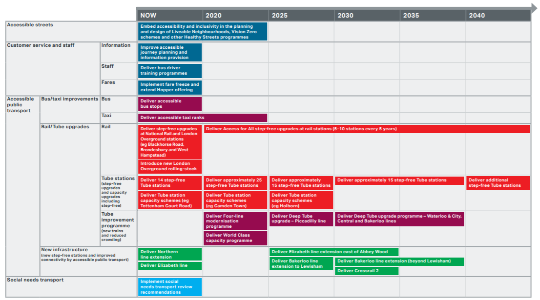
Simple solution: call them Northern City Line and Northern West End Line.