Wyvern Way is the northern perimeter of the Derby Triangle site.
At its west end (just west of Boots and Toys 'R us) is a roundabout, then a Burger King, then Costco; the eastern end of Chaddesden Sidings is at Costco's west end, and Network Rail's depot and the recently built Mercia House is the on the sidings' north side (immediately west of Costco). I think this may be the new depot being discussed.
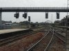
Most of the area which is now between the A52 Brian Clough Way (north side) and the current railway line west of Raynesway (the A5111 Derby ring-road) until it intersects the A52 (Eastgate) just to the east of the city centre was railway owned in the past. Apart from part of Chaddesden Sidings, the only other bit of historic railway infrastructure still standing (just!) is part of the Chaddesden wagon repair shops which was last used as the Fireplace Workshop; this will soon be demolished, and when road works presently being undertaken close to it are finished, it will be replaced by a new building which will include (according to local press report) a Nando's and a M&S Food.
The past rail uses for the site are reflected in names; the area occupied by the shops and offices immediately south of the A52 and west of Raynesway is called the Wyvern (which was, of course, part of the Midland Railway's coat-of-arms), and street names include Stephenson Way, Stanier Way, Pullman Road, and The Sidings.