From 1924 to March 1957 there was a large ammunition storage facility just off Sinderland Road, known as RAF Broadheath. During WW2 this made Altrincham and Sale a prime target - notwithstanding the industrial complexes locally.
Today there is very little left, a few concrete foundations and a bump in the road.
Many will remember the railway line which linked Timperley to Warrington which closed in the early 1980's - its main purpose was to carry coal from the South Yorkshire coalfields to Fiddler's Ferry Power Station via the old Woodhead Line. It's now a well used cycle path, part of the Trans Pennine Trail.
Just before Blackmoss Lane though, there used to be a small spur leading to RAF Broadheath which brought ammunition trains in and a series of sidings with underground bunkers. I have referenced the old 1955 OS map with the current maps and the sidings and buildings are clearly marked on the left hand map. The right hand satellite view shows a possible trace of the track in the yellow field.
Does anyone remember RAF Broadheath?
Today there is very little left, a few concrete foundations and a bump in the road.
Many will remember the railway line which linked Timperley to Warrington which closed in the early 1980's - its main purpose was to carry coal from the South Yorkshire coalfields to Fiddler's Ferry Power Station via the old Woodhead Line. It's now a well used cycle path, part of the Trans Pennine Trail.
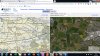
Just before Blackmoss Lane though, there used to be a small spur leading to RAF Broadheath which brought ammunition trains in and a series of sidings with underground bunkers. I have referenced the old 1955 OS map with the current maps and the sidings and buildings are clearly marked on the left hand map. The right hand satellite view shows a possible trace of the track in the yellow field.
Does anyone remember RAF Broadheath?