Pretty amazing that such a reduction in frequency for non event days was seen as politically acceptable.
Seems nobody noticed...
Pretty amazing that such a reduction in frequency for non event days was seen as politically acceptable.
Pretty amazing that such a reduction in frequency for non event days was seen as politically acceptable.
It had a pretty thorough consultation at the time. It might still be online somewhere?Seems nobody noticed...
Wimbledon, as the MP for that constituency had been pushing LU for an increase, which lead to the 20min 1 train peak step-back at High Street service.It had a pretty thorough consultation at the time. It might still be online somewhere?
But one of the stated benefits was more trains to Wimbledon and Richmond IIRC...
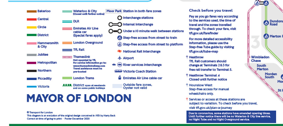
Tube map update
From January 2021, we’re temporarily adding the Thameslink rail network to our iconic Tube map. It’s hoped that this temporary addition will help our customers better plan their journeys and assist us managing demand across our network - facilitating safe social distancing. It will also support a series of forthcoming closures on the Northern line in 2021-22 as we continue our works to upgrade Bank station, which include weekend closures and a reduced service during the week.
Thameslink will provide more travel options for our customers, as it’s a high frequency service that operates through London.
The Thameslink service will be shown up to Zone 6 and indicate the final destination of the route. It will be distinguishable by a different line pattern design from TfL services, and the key will inform customers they need to check with Thameslink for additional customer service and accessibility information, as it’s not operated by us.
The updated map will be rolled out early next year, so keep an eye out for it.
Now the under-10-minute walking route dotted line between City Thameslink and St Paul’s is officially reflected on the tube map, that desperately needs to be added as an OSI. People are going to get surprise charges otherwise.
Not in Zone 1 there aren’t!There are other examples where a line is shown without an OSI being available (And vice-versa).
One extreme to the otherA copy of the map accompanied a press release that was put out this morning. It can be accessed at the following link https://cdn.prgloo.com/media/download/6d719b983b324761a393281605e1ffa8
One extreme to the other
The central core of Thameslink (West Hampstead/Finsbury Park to Elephant/London Bridge) should permanently be on the tube map, but it seems unnecessary to include the whole line out to Zone 8, especially when you end up with silly omissions like Woolwich Dockyard as Thameslink trains don't stop there!
it seems unnecessary to include the whole line out to Zone 8, especially when you end up with silly omissions like Woolwich Dockyard as Thameslink trains don't stop there!
I wouldn't be surprised if other TOCs begin to cry foul over preferential treatment given to TL. Someone looking at the Tube Map would think the way to get to Gatwick is via London Bridge, when there are Southern and GEX services from Victoria.
C2C accepted TfL fares on their service but they don't get a mention.
But, the reason why this has been done is because of the Northern Line works over the next year. It wouldn't surprise me if journeys that begin or finish on this section have their fares changed to match this as a true replacement service.there is an NR1-T fare surcharge on a mixed mode Z1 journey that includes TL south/east of London Bridge / Elephant & Castle, and north of Finsbury Park / West Hampstead Thameslink. I see no mention of that on the map
It’s too early yet.May I ask is the printed copy in stations yet?
thanks in advance
One extreme to the other
The central core of Thameslink (West Hampstead/Finsbury Park to Elephant/London Bridge) should permanently be on the tube map, but it seems unnecessary to include the whole line out to Zone 8, especially when you end up with silly omissions like Woolwich Dockyard as Thameslink trains don't stop there!
Why are New Southgate, Oakleigh Park and New Barnet on Thameslink? Surely they're GN only?
Has anyone been talking about how absolutely god awful it looks?
I agree. Surely the stations which have a regular service through the core should appear, not the ones that are Thameslink in name only.The (pre-Covid) half hourly peak only Kings Cross-Welwyn stoppers are "Thameslink" (as they - in theory - will eventually go through the core).
But that isn't congruent with the non-inclusion of any of the East Grinstead branch, which *does* have a peak core service today!
In my view, inclusion of any station north of Finsbury Park is odd - the next station with an regular core service is Stevenage!
That's not all, Herne Hill, Tulse Hill and Streatham are all horrifically bunched together, generally the way in which the line has to wind through existing lines and text makes it far less legible than before, not to mention South Croydon randomly being shown when the East Grinstead line isn't.The bend to fit in Purley / Coulsdon South looks odd...
Has anyone been talking about how absolutely god awful it looks?
I agree. Surely the stations which have a regular service through the core should appear, not the ones that are Thameslink in name only.
West Hampstead/Finsbury Park down to E&C/London Bridge should be shown but the rest of it shouldn’t be
No it shouldn't be. Thameslink has been added as a Northern Line alternative during closures. So, only the section that matches should be allowed.And the 8-10tph service to East Croydon isn't worth showing? Especially when East Croydon is on the map anyway for Tramlink.
No it shouldn't be. Thameslink has been added as a Northern Line alternative during closures. So, only the section that matches should be allowed.
I expected it on there tbh. Especially with the promotion of Croydon as a third/fourth economic hub for London.