• Our booking engine at tickets.railforums.co.uk (powered by TrainSplit) helps support the running of the forum with every ticket purchase! Find out more and ask any questions/give us feedback in this thread!

Edinburgh Tram developments

edwin_m

Veteran Member
Joined
21 Apr 2013
Messages
24,884
Location
Nottingham
So on the basis that there's a particular density of line on a map, you reward people far from town for their custom on the buses by taking them stand in the cold and change onto a tram halfway through the journey, make everybody closer to town walk further to a tram stop, and basically redesign the working transport system for the convenience of drivers going to a park and ride? Seems off to me
The better Continental networks have bus interchanges at the outer end of the tram routes where the buses pull right up to the tram platform, and timetables that ensure the bus is waiting as the tram arrives and returns to the ineterchange just before the next tram. This is possible because the areas still served by buses are outer suburbs where traffic congestion isn't a problem, partly because public transport is good enough that many people choose to leave the car on the drive!
 
Sponsor Post - registered members do not see these adverts; click here to register, or click here to log in
R

RailUK Forums

davetheguard

Established Member
Joined
10 Apr 2013
Messages
1,811
The better Continental networks have bus interchanges at the outer end of the tram routes where the buses pull right up to the tram platform, and timetables that ensure the bus is waiting as the tram arrives and returns to the ineterchange just before the next tram. This is possible because the areas still served by buses are outer suburbs where traffic congestion isn't a problem, partly because public transport is good enough that many people choose to leave the car on the drive!

Continental networks probably don't have deregulated buses like the UK (except London). If you have a transport authority with overall control, these sort of connections are straightforward to organise. If the transport authority has no control over commercial bus routes at all (as happens in the UK apart from London) they are difficult or even impossible to organise.

The Conservatives under Thatcher deregulated the buses and caused the problem, but Labour under Blair & Brown failed to reverse the policy.
 

edwin_m

Veteran Member
Joined
21 Apr 2013
Messages
24,884
Location
Nottingham
Continental networks probably don't have deregulated buses like the UK (except London). If you have a transport authority with overall control, these sort of connections are straightforward to organise. If the transport authority has no control over commercial bus routes at all (as happens in the UK apart from London) they are difficult or even impossible to organise.

The Conservatives under Thatcher deregulated the buses and caused the problem, but Labour under Blair & Brown failed to reverse the policy.
Absolutely agree. I probably should have been clearer that I was pointing out that it didn't have to be so if we had a sensible approach to buses. However, in Edinburgh they're all the same company under council control so perhaps it's possible in any case?
 

NotATrainspott

Established Member
Joined
2 Feb 2013
Messages
3,223
It isn't an either/or situation with trams and buses on a route corridor. Trams provide a better way to handle inner urban passengers on core routes. That means bus services can be recast to either provide new links, or allow them to run express and better serve the outer regions of the network. The main reason this works is that trams can handle a much larger throughput of passengers. You can't just replicate the combined bus+tram service pattern with buses alone. A huge factor is that trams have their own stops and have step-free access doors all along their length, so they don't suffer the capacity limit that busy bus stops create today.

The original Line 3 plan was to head eastwards towards Newcraighall along the route of the new developments in Craigmillar. It's possible that a different corridor will be picked instead. What you're looking for is a place to send trams so that some routes can be replaced entirely by tram without creating a need for people to interchange unnecessarily.
 

och aye

Member
Joined
21 Jan 2012
Messages
802
The original 3 line plan could see fruition this decade!


Edinburgh City Council is considering another huge extension to the capital's tram network.
The plans show a north/south line, running from Granton Harbour and down to either Roseburn or Shandwick Place, on the existing central tram line.
The line would then follow the existing city centre track, before turning south-east to the ERI and Bio Quarter.
There are also plans for a mass transit network, including trams, extending west from the airport to West Lothian.
The council plans to have a complete business case for the next tram extension by 2023, with a final business case set to be completed in 2025.
Subject to approval, the council is aiming to have the north/south tram line, and a westward expansion, completed by 2030.
The plans are included in The City Mobility Plan, which is due to be presented at a meeting of the transport committee on Friday 19 February.
 

geoffk

Established Member
Joined
4 Aug 2010
Messages
3,243
Haven't read all 43 pages, but is there a possible role for the long-disused Scotland Street tunnel as a tram route? I don't know much about it except that it's on a steep gradient.
 

takno

Established Member
Joined
9 Jul 2016
Messages
5,066
Haven't read all 43 pages, but is there a possible role for the long-disused Scotland Street tunnel as a tram route? I don't know much about it except that it's on a steep gradient.
I think it's tough to do because of the way it emerges at basement level in Princes Mall. That's a long way below where any of the tram routes are planning on running in the centre. It probably manages to skip a couple of pretty important stops in the centre as well. Better to just run it up and over George Street if you wanted to head in that direction.
 

devon_metro

Established Member
Joined
11 Oct 2005
Messages
7,715
Location
London
Haven't read all 43 pages, but is there a possible role for the long-disused Scotland Street tunnel as a tram route? I don't know much about it except that it's on a steep gradient.

I believe the plan is the use the Roseburn cycle/walking path to reach Granton. I imagine it would be pretty unpopular with users of said path and will never get built. Scotland Street tunnel would also destroy a popular walking/cycling route and there isn't much clearance outside Tesco at Canonmills
 

takno

Established Member
Joined
9 Jul 2016
Messages
5,066
I believe the plan is the use the Roseburn cycle/walking path to reach Granton. I imagine it would be pretty unpopular with users of said path and will never get built. Scotland Street tunnel would also destroy a popular walking/cycling route and there isn't much clearance outside Tesco at Canonmills
That might depend on whether the plan is to run it as a segregated route, or as (pedestrian-only) street running. If the formation is wide enough to only require sharing at some pinch points then it might work reasonably well.
 

NotATrainspott

Established Member
Joined
2 Feb 2013
Messages
3,223
The recent reports cover the problem that the original plans for the Granton line are no longer acceptable. The plan before had been to squeeze both tram lines in under and over minimally changed structures, with a relatively narrow path left over that wouldn't be much good for a busy mixed cycling and walking route. Now, they'll need to rebuild quite a few structures to provide a full width route, or they'll need to pick a different routing for the tram altogether. An unmentioned option would be to use gauntlet track through certain structures, but that would mean putting a fairly firm limit on maximum frequency.
 

och aye

Member
Joined
21 Jan 2012
Messages
802
Haven't read all 43 pages, but is there a possible role for the long-disused Scotland Street tunnel as a tram route? I don't know much about it except that it's on a steep gradient.
No chance.

The tunnel isn't big enough to accommodate one tram, let alone two.
 

FlybeDash8Q400

Established Member
Joined
26 Jun 2018
Messages
1,714
Location
Edinburgh
It appears to me there’s two major flaws with both proposed routes for the Western half of the Northern Loop.

The former railway (now obviously the cycle path) is not wide enough for two tram tracks and retaining the path in some places, and then in other places it’s incredibly expensive. More expensive overall but less likely to cause or be stuck in congestion.

Then you have this newer proposed route via Dean Bridge, Orchard Brae, Crewe Road South and Crewe Road North. This requires the removal of two roundabouts - Comely Bank, which probably isn’t much of an issue (could be signalised) and then Crewe Toll which would be nothing short of a mess of trams were to go that way. Queues are bad enough as it is on all approaches, adding trams would only make it worse. This is cheaper but is far more likely to cause congestion.

I think the original route is still the better option, however I’m reluctantly thinking that the council see it differently. The cheaper option via Crewe Road South is more likely I think.
 

OmniCity999

Established Member
Joined
30 Jan 2018
Messages
1,283
Location
Scotland
It appears to me there’s two major flaws with both proposed routes for the Western half of the Northern Loop.

The former railway (now obviously the cycle path) is not wide enough for two tram tracks and retaining the path in some places, and then in other places it’s incredibly expensive. More expensive overall but less likely to cause or be stuck in congestion.

Then you have this newer proposed route via Dean Bridge, Orchard Brae, Crewe Road South and Crewe Road North. This requires the removal of two roundabouts - Comely Bank, which probably isn’t much of an issue (could be signalised) and then Crewe Toll which would be nothing short of a mess of trams were to go that way. Queues are bad enough as it is on all approaches, adding trams would only make it worse. This is cheaper but is far more likely to cause congestion.

I think the original route is still the better option, however I’m reluctantly thinking that the council see it differently. The cheaper option via Crewe Road South is more likely I think.
My cousin works in Tram Control, im lead to believe the route down the cycle path has already been agreed to some extent.

The plan is to turn the entire route into what has been called an "urban road". It might not look like it to some, but this is the route it will take, double tracked. The path will be replaced with tram tracks, but i believe it wont be fenced off. Remember, the tram will have to run slowly anyway along this entire route, due to the proximity of housing.

The bridge will be replaced at Crewe Toll, there are a couple of instances where bridges and underpasses will need to be replaced or widened.

It will then run parallel to West Granton Access, under West Granton Road (with a new bridge installed to facilitate this. After this, it is to run along the path parallel to Waterfront Avenue, through the urban clearing (behind William Waugh), down the top of Granton Square and along the grass. A pinch point will be at the Old Chain Pier, but after that it will join up at ASDA.

It is going to be pricey but its fine, the council have a money printing machine.
 

FlybeDash8Q400

Established Member
Joined
26 Jun 2018
Messages
1,714
Location
Edinburgh
My cousin works in Tram Control, im lead to believe the route down the cycle path has already been agreed to some extent.

The plan is to turn the entire route into what has been called an "urban road". It might not look like it to some, but this is the route it will take, double tracked. The path will be replaced with tram tracks, but i believe it wont be fenced off. Remember, the tram will have to run slowly anyway along this entire route, due to the proximity of housing.

The bridge will be replaced at Crewe Toll, there are a couple of instances where bridges and underpasses will need to be replaced or widened.

It will then run parallel to West Granton Access, under West Granton Road (with a new bridge installed to facilitate this. After this, it is to run along the path parallel to Waterfront Avenue, through the urban clearing (behind William Waugh), down the top of Granton Square and along the grass. A pinch point will be at the Old Chain Pier, but after that it will join up at ASDA.

It is going to be pricey but its fine, the council have a money printing machine.
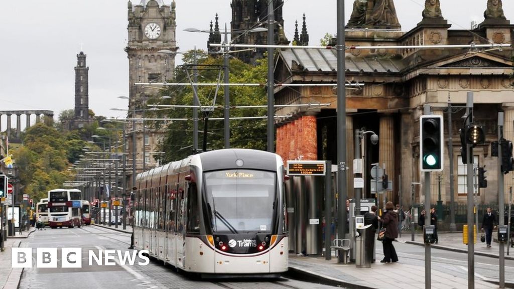
Yea I was walking the planned route last week as I live close to the proposed route, is certainly tight at points but I’d far rather it went that way.

Going along Lower Granton Road might result in land needing to be reclaimed as the road is narrow enough as it is and I can’t see the paths that were recently added being ripped up - mind you this is Edinburgh Council though so that’s probably a case of wait and see the blueprints. In any case I’m lead to believe the Granton to Newhaven connection is not being planned any time soon. Starbank Road and the Old Chain Pier (which is a lovely pub) are certainly obstacles to say the least.

I remember somebody telling me years ago (whether it was true or not) about the possibility of Newhaven Main Street being used but I’m glad that was ruled out rather quickly.

The bridge at Crewe Toll obviously has to go due to it being a footbridge, I imagine that will be sold off and moved elsewhere as it’s pretty rust free. The old railway bridge that was there and demolished was probably too small for tram use. Also there’s an old bridge next to Easter Drylaw Park that looks on the low side but I guess you could route it around it.

The path around West Granton Road area currently goes under the road at an angle (around to the back of the Morrisons petrol station), that may need an angled tunnel which is slightly more expensive to do too. And as you say some of the industrial units may go around Granton Square, although there’s a gap in the recently built housing at the Waterfront (at Saltire Square) for it to be able to go directly from that aforementioned petrol station to West Shore Road, just a case of the car dealer needing to move slightly (no demolition required).
 

OmniCity999

Established Member
Joined
30 Jan 2018
Messages
1,283
Location
Scotland
Yea I was walking the planned route last week as I live close to the proposed route, is certainly tight at points but I’d far rather it went that way.

Going along Lower Granton Road might result in land needing to be reclaimed as the road is narrow enough as it is and I can’t see the paths that were recently added being ripped up - mind you this is Edinburgh Council though so that’s probably a case of wait and see the blueprints. In any case I’m lead to believe the Granton to Newhaven connection is not being planned any time soon. Starbank Road and the Old Chain Pier (which is a lovely pub) are certainly obstacles to say the least.
No land is earmarked to be reclaimed, the trams are to run along the grass from Granton Square* to the water works at the junction of Trinity Road. It would then join the junction creating a pinch point between there and ASDA. No land is being reclaimed and nothing in that area is being demolished. The Roundabout at the junction of Craighall Road and Starbank road will be removed. Starbank Road will be subject to traffic enforcement. The parking on Pier Place and Lindsay road will be removed or single sided.

*there maybe a small pinch point between Granton Squre, the apartments and the start of the grass, this would lead to road alterations to accommodate trams

Ideally the only place that would see land reclaimed is between the junction of Lower Granton Road and Trinity Road to Newhaven Harbour. However, reclaiming land is where costs get astronomica. Its also not required. It means trams running amid traffic, which isnt ideal - however it is doable.
I remember somebody telling me years ago (whether it was true or not) about the possibility of Newhaven Main Street being used but I’m glad that was ruled out rather quickly.
Negative
The bridge at Crewe Toll obviously has to go due to it being a footbridge, I imagine that will be sold off and moved elsewhere as it’s pretty rust free. The old railway bridge that was there and demolished was probably too small for tram use. Also there’s an old bridge next to Easter Drylaw Park that looks on the low side but I guess you could route it around it.
Thats the route it is to take so it'll likely see the bridge replaced.
The path around West Granton Road area currently goes under the road at an angle (around to the back of the Morrisons petrol station), that may need an angled tunnel which is slightly more expensive to do too. And as you say some of the industrial units may go around Granton Square, although there’s a gap in the recently built housing at the Waterfront (at Saltire Square) for it to be able to go directly from that aforementioned petrol station to West Shore Road, just a case of the car dealer needing to move slightly (no demolition required).
The tram route is to follow the path and the cost of adding a third lane (to accommodate the curve) in the underpass is negligible on this type of project.

I never said anything would need to "go".

After this, it is to run along the path parallel to Waterfront Avenue, through the urban clearing (behind William Waugh), down the top of Granton Square and along the grass.
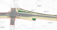
The area between Waterfront Avenue and Granton Square has been left clear for tram expansion. Although, consideration would need to be taken regarding overhead power and the William Waugh facility. Its currently an urban clearing containing excess earth and vegetation. (attached is an image of the area)
 

Attachments

  • Screenshot 2021-03-02 at 21.34.20.png
    Screenshot 2021-03-02 at 21.34.20.png
    662.5 KB · Views: 61
Last edited:

A330Alex

Member
Joined
13 Feb 2019
Messages
223
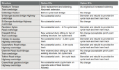
The full list of structures work that would be needed for the Roseburn Path option (from the rather mouthy Edinburgh Strategic Sustainable Transport Study Phase 2 Summary Report):
Screenshot_989.png
(Option B1a was discarded due to the impact on the active travel route.)

If anyone is ever bored, you can actually look through the initial plans for the Granton line from way back in 2007/8 on the CEC planning portal:
Screenshot_990.png
 

Clip

Established Member
Joined
28 Jun 2010
Messages
10,822
Wow this is interesting - me and her loved our trip the other year in Edinburgh on the trams and probably saw more than if we were restricted to the buses/trains. Cant wait to see this happen
 

Aictos

Established Member
Joined
28 Apr 2009
Messages
10,403
With the map above, is it intended for the trams to run all the way from Edinburgh Airport to Newhaven or will they operate as two routes eg Edinburgh Airport to York Place and York Place to Newhaven?

Also with the above extension, are they going to need more trams or will they be able to operate the new timetable with their existing fleet?
 

Elwyn

Member
Joined
5 May 2014
Messages
439
Location
Co. Antrim, Ireland
I am fairly sure the intention is run through from the Airport to Newhaven. Lots of visitors stay in Leith and there'd be plenty of demand. I think they bought enough trams to cover the extended route. (The truncated route meant they had too many).
 

FlybeDash8Q400

Established Member
Joined
26 Jun 2018
Messages
1,714
Location
Edinburgh
With the map above, is it intended for the trams to run all the way from Edinburgh Airport to Newhaven or will they operate as two routes eg Edinburgh Airport to York Place and York Place to Newhaven?

Also with the above extension, are they going to need more trams or will they be able to operate the new timetable with their existing fleet?
I am fairly sure the intention is run through from the Airport to Newhaven. Lots of visitors stay in Leith and there'd be plenty of demand. I think they bought enough trams to cover the extended route. (The truncated route meant they had too many).
I believe the plan is to run most trams the full route and then some extra ones running from Haymarket to Newhaven, the latter ones are planned to run beyond Haymarket and or Newhaven if it’s extended (eventually a loop service).
 

92002

Member
Joined
27 Mar 2014
Messages
1,133
Location
Clydebank
I believe the plan is to run most trams the full route and then some extra ones running from Haymarket to Newhaven, the latter ones are planned to run beyond Haymarket and or Newhaven if it’s extended (eventually a loop service).
When trams were ordered there was enough for the original planned lines.
 

FlybeDash8Q400

Established Member
Joined
26 Jun 2018
Messages
1,714
Location
Edinburgh
When trams were ordered there was enough for the original planned lines.
Yes the current fleet of 27 were ordered for the 2007 proposal, but I believe it is still the plan to run trams part route from Haymarket to Newhaven and not the full route, that may change over time though. The short working services will eventually run Granton to Newhaven via Haymarket (if planned route happens), ultimately these are trams not planned to go to the Airport in the long run hence why they’re only running part route.

It’s not a lot that would terminate at Haymarket, probably every 3rd or 4th at most. It’s one of the reasons that the siding outside the Tesco offices was put in.
 
Last edited:

FlybeDash8Q400

Established Member
Joined
26 Jun 2018
Messages
1,714
Location
Edinburgh
Suprising amount that's stated as 'not started'; does this really mean, totally not started?
It looks as if the bits that aren’t started at all are junctions that are still in use, for example Pilrig Street. Not sure when they’ll get round to these possibly when they can open up a few of the other bits as diversions maybe?
 

NotATrainspott

Established Member
Joined
2 Feb 2013
Messages
3,223
The business case for the Newhaven completion is for 12tph. That's from the current 8tph service to the Airport running all the way to Newhaven, plus another 4tph terminating short at Haymarket. 16tph (8tph Airport, 8tph Haymarket) would happen later once passenger numbers increase.

The Granton line is now being talked about as part of a complete north-west to south-east line, so it isn't necessarily the plan to run the Newhaven trams up to Granton. 16tph out to Edinburgh Park is also a future plan, although the extra 8tph is able to be earmarked for other western extensions like Newbridge.
 

och aye

Member
Joined
21 Jan 2012
Messages
802
With the map above, is it intended for the trams to run all the way from Edinburgh Airport to Newhaven or will they operate as two routes eg Edinburgh Airport to York Place and York Place to Newhaven?

Also with the above extension, are they going to need more trams or will they be able to operate the new timetable with their existing fleet?
@Elwyn @NotATrainspott and @FlybeDash8Q400 have answered your question. :) Just to say that the York Place tram stop is to close and be replaced with Picardy Place as was originally intended.
 
Last edited:

devon_metro

Established Member
Joined
11 Oct 2005
Messages
7,715
Location
London
How much closer is Picardy Place to Edinburgh Waverley?

St Andrews Square would be the closest tram stop to Waverley. Picardy Place tram stop is going to be located in the middle of a roundabout, so it's quite hostile for pedestrian access, unless you enjoy waiting at traffic lights.
 

Top