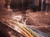
This one of the old tunnels from Kings Cross to Moorgate,you can access these tunnels off York way, when were they closed?.
And they would come in useful now, as they would be doing to same thing as the new Canal Tunnels at St Pancras International
This one of the old tunnels from Kings Cross to Moorgate,you can access these tunnels off York way, when were they closed?.You are right, there is a tunnel that splits half way down,that was the first one the other is just off the platform edge at kx thameslink.That looks to me like the entrance to the York Road curve just beyond the platforms of what used to be Kings Cross Thameslink. This and Hotel Curve were closed in 1977.
Sincerely doubt either tunnel could be used now with all the reconstruction in the area. I read somewhere - possibly Clive Feather's site - that Hotel Curve now contains a gas main.
That looks to me like the entrance to the York Road curve just beyond the platforms of what used to be Kings Cross Thameslink. This and Hotel Curve were closed in 1977.
Sincerely doubt either tunnel could be used now with all the reconstruction in the area. I read somewhere - possibly Clive Feather's site - that Hotel Curve now contains a gas main.
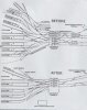
In that case i have never seen the northbound tunnel,where did it come out? KX Thameslink like the southbound?The lines between Finsbury Park and Farringdon ran either side of Kings Cross. The southbound line went through Kings cross York Road on the eastern side of Kings Cross. The northbound line ran down the western side of Kings Cross.
In that case i have never seen the northbound tunnel,where did it come out? KX Thameslink like the southbound?
I'm down there next weekend i will have a proper look
In that case i have never seen the northbound tunnel,where did it come out? KX Thameslink like the southbound?
I'm down there next weekend i will have a proper look
And a video:
[youtube]rcpb9oZ6f3g[/youtube]
")
Okay so, is the op's picture taken further into the tunnel than I first thought. I reckoned it was at KX T/link but if not then that is the Northbound tunnel in the picture.
You can drive down the tunnels,they haven't been touched,the cabling routes are still there,i go down there every week.
The picture is a said above,drive down towards KX Thameslink the tunnel splits off to the right that is what the picture is of, but form the other side.
The tunnel carries on to KX Thameslink station which is the one westcoaster seen the BCM van who are putting up the new signals for phase 1.
Let me get this straight then the one that you can see from KX Thamelink is the southern tunnel? and the one the picture is of is the northern tunnel?.
Somebody said above that the northern tunnel was on the opposite side of Kings Cross station
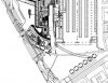
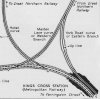
Your map makes sense to me looking at it, but it is missing the split, i going to agree with you that the split must be the maiden lane curve.I've attached a scanned picture from 1962, might help with the overall layout:
i never knew about the hotel curve despite using kings cross for years. i always hoped the kings cross redevelopment would move platforms 9-11 further south so it wasn't such a walk. where did the hotel curve emerge?
If it is maiden lane curve, where is the northbound tunnel, i'm assuming it would be further north towards St Pancras.
I've never heard of the Maiden Lane curve though. From the map, it looks as though it diverged from the York Road curve just inside the tunnel ie just after leaving York Road station, but where did it end up. on what is now the Thameslink line, or did it connect up to the Circle/Metropolitan line? And if so, how did it cross the Thameslink line?
Can you send me all the maps, diagrams you have on this section?