There's several smaller curiosities along the way to add!
Just north of Carlton (church to the west, Great Northern pub east) is an occupied windmill to the east, with rooms on 5 floors. From here, you can see Lincoln Cathedral on its ridge in the far distance.
The remaining blue mass of the abandoned Harwoth Colliery stands high in the west, just before . . .
The line round the village of Bawtry is on a viaduct. A very low viaduct, but quite unusual.
4 miles before Doncaster, there is Potteric Carr nature reserve and lake on the east, but oddly, the bird-watcher's hide is on the west. (Seems odd that big noisy trains thunder through between the hiding twitchers and the birds).
On the approach to Doncaster station (from the s.) the line passes under a road bridge (Balby Bridge aka Tunnel) where the brickwork on the east side has an opening through which a ragged piece of red sandstone pokes through (looks very odd)!
Look for the white belltower on top of the former railway works on the west side of the station (southern end).
At Temple Hirst Junction, as well as watching 5 power stations (Drax & Rawcliffe to the east, Eggbourgh to the west, and Castleford and Ferrybridge far west) there's also the Temple which gives the junction its name, on the site of a former Knights Templar outpost (now a rest home!).
There's a hill to the east, Brayton Barff, it has a reservoir at the top!
Leaving York with the Ouse to the east, you can see the rotating Hogate windmill to the west.
There's 3 old metal signs (on both sides) within 8 miles, 'Edinburgh 200 miles', 'Edinburgh - London halfway' & 'London - 200 miles'.
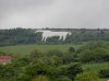
There's one of those large white horses on a hillside somewhere between Darlington and York.
Yes, its on the side of the North Yorkshire moors, visible south of Thirsk, but when there's been snow, the horse becomes lost in the white background.
There's a similar big old white metal sign, north of Northallerton where you cross the River Tees, there's a fine metal sign announcing 'Yorkshire', but on the other side, its more like a road traffic sign with brown background and small print 'Durham'.
Immediately before crossing the Wear, Croxdale Hall is on the east.
On the approach to Durham City, on the west, there's the grand National Union of Mineworkers building, more like a methodist chapel in style inside, with green copper domes. Arthur Scargill met here often during those difficult years for the mines and miners. Just visible over the trees is the tall pinnacle of an astronomical needle high on a hill overlooking the station. Its slits can be used to line up stellar objects.
Lumley Castle is a mile or so away but very visible on the approach to Chester-le-Street, but on a distant hiltop beyond is the Penshaw Monument, a mini-Acropolis with no roof, is visible maybe only in sillouette on the skyline.
Passing out of Newcastle, a magnificent deco factory once making Wills cigarettes is next to the line on the west, now appartments but retaining its character.
The Morpeth curve sees the slowest speeds other than at stations. Too many trains had come off the line there at speed.
Approaching Alnmouth (and beyond it) you'll see the large white 'golfball' long-distance radar dome at Boulmer, but further away and to the west, there's another, way beyond Alnwick. The combined received data from the two allows distance and angle to be measured more accurately.
Just 2 miles north of Alnmouth, on a hill-top to the west, is a folly, mainly consisting of an elevated observatory with glass on all four sides rasied on an arch. Its owned by the Duke of Northumberland.
The sand dunes nearby to the east are 'protected' and are (or were) the highest dunes in Europe.
North of Berwick, after looking over the precipitous red cliffs to the sea below, is the 90 degree curve west wards and I'll assure you that Ayton Castle (just n. of the Eng-Scot Border) is far from being distant and hard to see! Its red-sandstone and turrets make it radiate a deep red colour in the setting sun!
Mention has been made of the sad loss of life in the Penmanshiel Tunnel. But we can add that this is the highest point in the journey between Edin & London, and the descent from here to the sea at Cockburnspath is the steepet sustained gradient, reaching 1 in 96 for 3 miles!
After Dunbar, there's an old windmill to the west, at the site of the 1650 Battle of Broxburn.
In addition to the Bass Rock (out to sea), there are 2 almost perfect peaks, former mini-volcanos, one inland at Trapain, one seaward at north Berwick.
A few ruins, castles, and standing stones later, you see the last volcano in Edinburgh itself, Arthur's Seat, with the new Scottish parliament complex below.
")