Wyvern
Established Member
- Joined
- 27 Oct 2009
- Messages
- 1,573
") So where is it then?
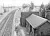
So where is it then?And here is the view from the bridge today (the line curves in the opposite direction): http://maps.google.co.uk/maps?q=birtley&hl=en&ll=54.895322,-1.585325&spn=0.019818,0.052357&sll=53.800651,-4.064941&sspn=20.929552,53.613281&t=h&hnear=Birtley,+Tyne+and+Wear,+United+Kingdom&z=15&layer=c&cbll=54.895322,-1.585325&panoid=kqKPMP3GXsxt5ZNZ8u-XZg&cbp=12,152.85,,1,4.13
Well, you've done well to transform the evidence to fit the circumstances!Does this help?
I'm sure Wyvern's question is a genuine request for knowledge, and (s)he would be delighted to have the question answered.Thanks to the wonders of Google, I have found where it is. However I'm not sure if thats cheating.
I'm sorry to say that all you have done is repeat the incorrect response which bolli posted from the same unreliable source in post #4 (the reasons for rejecting that are in the follow-up replies and is even refered to in that Wikipedia entry as questionable).
Someone's not paying attention to the lesson
And the poster of the photo even states in a subsequent photo he posted of Birtley Station that it isn't Birtley.I'm sorry to say that all you have done is repeat the incorrect response which bolli posted from the same unreliable source in post #4 (the reasons for rejecting that are in the follow-up replies and is even refered to in that Wikipedia entry as questionable).
Someone else identified the letters on the notice board as "LMS" so that fits, as Berrington and Eye was a joint LNWR/GWR station on the Shrewsbury and Hereford line.