jamesontheroad
Established Member
- Joined
- 24 Jan 2009
- Messages
- 2,045
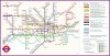
Just discovered this via the ever entertaining transitmaps.tumblr.com - it's a London Underground map with track diagrams, junctions and platforms included:
Aeracode: a series of twin tubes
Work in progress, so some details may not be accurate.
Aeracode: a series of twin tubes
Work in progress, so some details may not be accurate.