• Our booking engine at tickets.railforums.co.uk (powered by TrainSplit) helps support the running of the forum with every ticket purchase! Find out more and ask any questions/give us feedback in this thread!

How should schematic rail maps of the UK look in a post-GBR scenario?

Status
Not open for further replies.

PTR 444

Established Member
Joined
22 Aug 2019
Messages
2,282
Location
Wimborne
I was going to post this in the existing GBR branding thread, but I think this deserves a topic in its own right. Basically, if Great British Railways adopts a single unified brand (by that I mean like the old BR - a single livery for the entire UK rail network), what could the implications be for schematic railway mapping?

For example, the London & South East railway map is displayed at almost every station in the region and is a very useful tool for identifying who operates which services. If however there is no longer any distinction between operators and indeed brands, then what is the point of showing services in separate colours? Well, for a schematic map to work, you need to have some sort of colour distinction between routes so it works as a piece of information design. In the event that there is only one operator, why not take this opportunity to group the colours by another means of data, like which London Terminal the service runs to?

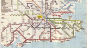
The attached NSE map from 1990s did just that with more distinction between routes then there is now, such as using using separate colours for the Chatham and South Eastern mainlines, and having a separate identity altogether for the North Downs Line. Such distinction didn’t matter then as all NSE trains were operated and branded the same, so this approach could potentially be used again if GBR becomes a unified brand for the entire British rail network.

The other option is to colour code routes on the map based on speed, so basically one colour for fast, one for semi-fast and one for all stations. This could work from a passenger perspective since customers would know exactly which services stopped where, but you would also lose the regional distinction between lines. You could use alternatively use groups of colour for each region, so for example, SWR shown in various shades of red with darker shades denoting faster services, but adding too many distinctions would make the map way to cluttered and lose clarity as a piece of information design.

With so many possibilities, I think it would be a good idea to discuss what the future holds in store for the LSE and other schematic rail maps in a post-GBR scenario. Do you see these staying in their current form, becoming more diverse in response to a unified brand, or simply being scrapped altogether in favour of more personalised, digital alternatives?
 

Attachments

  • 72FE9356-1FFD-479D-91AF-E334AE865F75.png
    72FE9356-1FFD-479D-91AF-E334AE865F75.png
    2 MB · Views: 159
Last edited:
Sponsor Post - registered members do not see these adverts; click here to register, or click here to log in
R

RailUK Forums

biko

Member
Joined
8 Mar 2020
Messages
491
Location
Overijssel, the Netherlands
I don't think a map will be really important as most people just plan a journey online or in an app. But if making a map, I think a nice way would be using colours for service groups or services from specific terminals and line types to show the speed of the service. So thicker lines or dotted lines for example for fast services. Another idea is to use the line thickness to show frequency.
 

HSTEd

Veteran Member
Joined
14 Jul 2011
Messages
16,706
The obvious model is the New York Subway, where line colours are selected based on what line is used by the subway in Manhattan (unless you are the G train, which doesn't go to Manhattan).

So you could have a colour for Thameslink, a colour for Crossrail, a colour for KGX, a colour for Euston etc etc etc
 

JonathanH

Veteran Member
Joined
29 May 2011
Messages
18,756
Such distinction didn’t matter then as all NSE trains were operated and branded the same, so this approach could potentially be used again if GBR becomes a unified brand for the entire British rail network.
Not quite - the NSE trains each had route branding in a suitable location on their body sides.
 

JaJaWa

Established Member
Joined
14 Feb 2013
Messages
1,705
Location
Up until 2011, ATOC (now RDG) and TfL each published their own version of "London's Rail & Tube services" map before they were merged into one.

The TfL map (called "Oyster Rail services in London" map) coloured lines by London terminus.

The ATOC map (called "London Connections") coloured lines by TOC.

You can see the various maps over time here: http://projectmapping.co.uk/Reviews/londontubeandrai.html

TfL's last non-TOC map can be seen here: http://projectmapping.co.uk/Reviews/Resources/oyster-rail-services-map 28211.pdf
 

BayPaul

Established Member
Joined
11 Jul 2019
Messages
1,224
This is one reason why I think branding certain trains as Intercity or similar would be useful, it would make it easier to highlight the faster long distance trains on maps, timetables, journey planners, departure boards and platforms. Not just limited to former BR IC routes, I would include basically anything identifiable as long distance that runs as limited stop on a significant part of its route, so things like Northern Connect, Portsmouth-Cardiff, Southeastern high-speed etc would be included.

I would also look to keep routes like Thameslink with their own distinctive (sub) branding, to emphasise that they have a different service pattern to the other trains on the route.
 

Western Lord

Member
Joined
17 Mar 2014
Messages
782
Why do people think that a unified brand is coming back. Even under nationalised British Rail there were different brands for different services. I do not expect any change to the branding of passenger services, which were increasingly being mandated by the DfT anyway.
 

Bletchleyite

Veteran Member
Joined
20 Oct 2014
Messages
97,783
Location
"Marston Vale mafia"
Why do people think that a unified brand is coming back. Even under nationalised British Rail there were different brands for different services. I do not expect any change to the branding of passenger services, which were increasingly being mandated by the DfT anyway.

Because several of the newspaper articles say it will. Though some also speak of "regional railway brands" which suggests the current TOC brands (other than maybe Avanti?) might stay.
 

Western Lord

Member
Joined
17 Mar 2014
Messages
782
Because several of the newspaper articles say it will. Though some also speak of "regional railway brands" which suggests the current TOC brands (other than maybe Avanti?) might stay.
The newspaper articles have got the wrong end of the stick. People are reading way too much into this. The last thing a Conservative government wants is to be seen to be recreating anything resembling British Railways.
 

Bletchleyite

Veteran Member
Joined
20 Oct 2014
Messages
97,783
Location
"Marston Vale mafia"
The newspaper articles have got the wrong end of the stick. People are reading way too much into this. The last thing a Conservative government wants is to be seen to be recreating anything resembling British Railways.

Just about the most popular political policy that could be imagined is renationalisation, so even though that's not what they are doing I wouldn't put populist Boris apart from that idea, to be honest.
 

swt_passenger

Veteran Member
Joined
7 Apr 2010
Messages
31,382
NSE was really just a marketing grouping. I see the first post suggests it was “operated the same”…
The Southern Region part of BR was never amalagamated to the extent it was operated as one, the Southwestern division, Central division and Southeastern division existed internally, then continued during the NSE period, then became the three shadow train operating units, then they became the three TOCs.
 

Western Lord

Member
Joined
17 Mar 2014
Messages
782
Just about the most popular political policy that could be imagined is renationalisation, so even though that's not what they are doing I wouldn't put populist Boris apart from that idea, to be honest.
I think that you overstate the popularity of renationalisation. It might be a popular policy among regular rail travellers (many of whom have no personal experience of what rail travel was like under BR), but the vast majority of the population don't get on a train from one years end to the next and only think about it when asked by a pollster. They then give the answer that the question is framed to get, whilst carrying on polishing their new car.
 

JaJaWa

Established Member
Joined
14 Feb 2013
Messages
1,705
Location

Doctor Fegg

Established Member
Joined
9 Nov 2010
Messages
1,837
And the review itself says:
Variants to the national brand will be developed to refect the English regions, Scotland and Wales, while emphasising that the railway is one network serving the whole of Great Britain.
So I wouldn't be surprised to see GWR retained as the brand for the West of England, for example. Just with extra double arrows and nationally-influenced typography/design.
 

Western Lord

Member
Joined
17 Mar 2014
Messages
782
And the review itself says:

So I wouldn't be surprised to see GWR retained as the brand for the West of England, for example. Just with extra double arrows and nationally-influenced typography/design.
So this means that the double arrow goes back up outside London Overground stations!
 

YorksLad12

Established Member
Joined
5 Feb 2020
Messages
1,888
Location
Leeds
I think "national branding" means exactly that, it doesn't mean the bit of content between the branding has to be uniform. The bloated Underground Map will still show the cable car, for example. Named routes will still appear. People round my way will still refer to the Huddersfield Line, etc (indeed, today's published document has a class 331 on the Wharfedale Line which no longer exists according to WYCA).

So this means that the double arrow goes back up outside London Overground stations!
I didn't realise it wasn't. Sacriledge!
 

Wolfie

Established Member
Joined
17 Aug 2010
Messages
6,149
So this means that the double arrow goes back up outside London Overground stations!
An interesting question, at least when it comes to parts of the former East London line which, as far as l am aware, have never been part of National Rail.
 

BrianW

Established Member
Joined
22 Mar 2017
Messages
1,448
Up until 2011, ATOC (now RDG) and TfL each published their own version of "London's Rail & Tube services" map before they were merged into one.

The TfL map (called "Oyster Rail services in London" map) coloured lines by London terminus.

The ATOC map (called "London Connections") coloured lines by TOC.

You can see the various maps over time here: http://projectmapping.co.uk/Reviews/londontubeandrai.html

TfL's last non-TOC map can be seen here: http://projectmapping.co.uk/Reviews/Resources/oyster-rail-services-map 28211.pdf
I see the attraction of a London tube-like look which seems to 'work' in terms of people (esp tourists and infrequent travellers) being able to plan and check as they go with clear interchanges, signage etc which can be followed easily with their own interpretation of colour etc. But even the tube map requires differentiation between red and red (is that maroon, crimson, orange?).
A national map like that 'one hell of a job'. Even the tube needs some understanding eg Northern Line at Camden Town or Euston and does it link to Euston Square, etc etc.
Maybe someting like a bus map, IF one had consistent routings and not more like nearly everywhere to everywhere? Table 51> Train 51? 51/A/B/...
It's rather cart before horse?
Maybe the more important thought is around 'Great' and the 'imposition' of 'the flag' onto the devolved authorities. I'm sure the double-arrow can be melded into something very union-jackish red-white-and-blue centred somewhre around a red/blue wall (Darlington?)
 
Status
Not open for further replies.

Top