• Our booking engine at tickets.railforums.co.uk (powered by TrainSplit) helps support the running of the forum with every ticket purchase! Find out more and ask any questions/give us feedback in this thread!

Leeds - bit of railway archeaology

Status
Not open for further replies.

BC

Guest
Joined
4 Feb 2019
Messages
104
Hello all,

Wondering if you might be able to help me with a little old railway research...

Armley in Leeds has an estate with a curious "slot" cut through the housing estate - as seen on this overhead here..


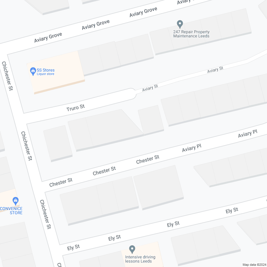
The cut through in question is the one halfway down Truro Street, Chester Street etc that moves at an angle though the houses. The terraces to the west of the cut through are considerably older (late 1880s) that the ones on the east (1905-ish) however they two terraces were never joined up so somthing was here...

If you follow the line it starts to take a curve where it gets to Aviary Mount and then the curve is lost - however if you follow the curve it arrives about here...


This used to be an old 1870's brickworks. The line that this follows is roughly level (not perfectly) but a lot more level than other routes would be.

I'm guessing it's an old narrow gauge line for getting bricks out the works to the mainline - or perhaps not even that could even be a basketway of some kind. Just wondered if anyone on here could shed more insight?

Thanks.
 
Sponsor Post - registered members do not see these adverts; click here to register, or click here to log in
R

RailUK Forums

30907

Veteran Member
Joined
30 Sep 2012
Messages
17,989
Location
Airedale
https://maps.nls.uk/view/125642401

I've had a play around with this site - the 1906 map shows a clear demarcation with the area to the NE not yet built, and an earlier one shows a field boundary or similar, but I can't find any sign of a railway or even a path, and it's not clear where such would have gone to and from. Curious.
The brickworks on Stanningley Road is some way from the feature you describe.
 
Last edited:

BC

Guest
Joined
4 Feb 2019
Messages
104
Ooh thats nice I'd not seen that one I was looking at the earlier 25 inch maps on there.

It is very tenous but if you project what little is left of the curve from what can be inferred on the ground - assuming it was in fact a railway - then you do end up pointing at the brickworks. It also would be the flattest possible route through the estate if you did that and perfectly possible to run rail operations on it. Thats what got me thinking.
 

John Webb

Established Member
Joined
5 Jun 2010
Messages
3,063
Location
St Albans
I suspect this feature is due more to local land ownership at the time - one of the landowners may have insisted the newer housing was built a short distance away from the existing buildings, perhaps? And if it followed old land boundaries...
 

30907

Veteran Member
Joined
30 Sep 2012
Messages
17,989
Location
Airedale
Ooh thats nice I'd not seen that one I was looking at the earlier 25 inch maps on there.

It is very tenous but if you project what little is left of the curve from what can be inferred on the ground - assuming it was in fact a railway - then you do end up pointing at the brickworks. It also would be the flattest possible route through the estate if you did that and perfectly possible to run rail operations on it. Thats what got me thinking.
Looking at the next OS sheet west, the houses west of Armley Lodge Road were also built by 1906 and would have cut right across the "railway" formation. I'll go with John Webb's suggestion. It wouldn't be at all unusual to have housing ending abruptly at a property boundary.
 

BC

Guest
Joined
4 Feb 2019
Messages
104
I agree its the end of a property boundary sure - it's just that the shape of that boundary appears to be shaped to that of a railway line thats all! This is what got me thinking there was once a line there....
 
Joined
21 Oct 2012
Messages
937
Location
Wilmslow
https://maps.nls.uk/view/125642398

The 1893 25in OS map shows the 'slot' as a field boundary - the 'spec' builders of the period often built right up to then resulting in some odd shaped houses. Of interest is the notorious Roberts asbestos factory nearby, which made lagging for steam boilers. This was expanded in the 1920s when Turner and Newall took over - the housing infill in the 'Aviary' streets looks to me be from this period rather than pre-WW1. The whole area was grossly contaminated with many cases of mesothelioma.

Edit. 'Britain from Above' has a good aerial shot from 1926 (bottom left) - if you register and login you can zoom in.

https://www.britainfromabove.org.uk/en/image/EPW017303
 
Last edited:

DelW

Established Member
Joined
15 Jan 2015
Messages
3,861
Just a suggestion - years ago I saw something similar in west London (I first saw it from a plane approaching Heathrow). It turned out to be the route of major water mains linking one of the Thames-side treatment works to a service reservoir in north London. On satellite view it was possible to trace it on and off for several miles, as the then Metropolitan Water Board, or possibly a predecessor, had ensured the wayleave was kept clear of any buildings.
 

BC

Guest
Joined
4 Feb 2019
Messages
104
I live right in the middle of that yes - we know all about T&N and their Federal successors sadly :(
Just a suggestion - years ago I saw something similar in west London (I first saw it from a plane approaching Heathrow). It turned out to be the route of major water mains linking one of the Thames-side treatment works to a service reservoir in north London. On satellite view it was possible to trace it on and off for several miles, as the then Metropolitan Water Board, or possibly a predecessor, had ensured the wayleave was kept clear of any buildings.

Ummm - thats not a bad suggestion either - there used to be a town gas works nearby and it could well be a gas pipe I suppose.
 
Status
Not open for further replies.

Top