• Our booking engine at tickets.railforums.co.uk (powered by TrainSplit) helps support the running of the forum with every ticket purchase! Find out more and ask any questions/give us feedback in this thread!

Mottram Yard query

Status
Not open for further replies.

Electro-Pie

Member
Joined
9 Jul 2005
Messages
13
Location
Derbyshire
Hello all. This is my first time posting since 2005, I knew this 16 year old account would come in handy one day...!

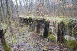
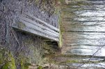
I've been exploring a bit round my local area recently, round Tameside/Hyde/Glossop. Went to the old Godley turntable last week and then yesterday came across this old wooden platform buried in the woods near the old Mottram yard, towards the Broadbottom end.

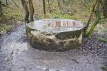
From the approximate location and looking at old maps of the line, I assumed it would have been part of the yard — but looking at old photos from back in the day I can't make out any platforms in the yard itself. It's not the staff halt as that is clearly visible further up line toward Glossop Road bridge. There's also this circular structure nearby, which looks like some sort of capped shaft? Again I couldn't find anything about it but maybe I'm looking in the wrong place.

Anyone who knows the area able to shed any light? Thanks!

(PS if a mod could please tell me how to remove the signature image I made as a teenager ... that would be lovely )

DSC01538.JPG
 

Attachments

  • DSC01539.JPG
    DSC01539.JPG
    1.4 MB · Views: 26
  • DSC01544.JPG
    DSC01544.JPG
    1.2 MB · Views: 30
  • DSC01546.JPG
    DSC01546.JPG
    1.2 MB · Views: 31
Sponsor Post - registered members do not see these adverts; click here to register, or click here to log in
R

RailUK Forums

Gloster

Established Member
Joined
4 Sep 2020
Messages
8,423
Location
Up the creek
A diagram in Trains Annual 1966 shows a Cattle Loading Dock at the west end of the yard on the south side of the throat: the line serving it was the furthest from the running lines. It might have been for local traffic, but was more likely for removing animals for feeding or for veterinary checks during their journey, or for swapping from one cattle truck to another if the first had to be stopped. The circular structure might just be a cap over a well.
 
Joined
21 Oct 2012
Messages
938
Location
Wilmslow
The yard layout is shown on the 1954 6in OS Map (unfortunately the 25in maps available predate the yard's construction).

Mottram Yard

The dock is visible at the SW end, and looks to have road access. Local goods were handled at the Dinting Goods Station the other side of the Glossop Road bridge however - perhaps it was just for engineering access?
 

Gloster

Established Member
Joined
4 Sep 2020
Messages
8,423
Location
Up the creek
The Cattle Dock marked on the Trains Annual diagram was on the south side of the dead end sidings out to the left-hand end of the map. The diagram shows two cripple sidings and one shorter cattle dock siding with the dock on the south side. As there were twenty yard roads and an engine road, the map is a bit of a simplification.
 

Electro-Pie

Member
Joined
9 Jul 2005
Messages
13
Location
Derbyshire
Thanks all for the replies!

A diagram in Trains Annual 1966 shows a Cattle Loading Dock at the west end of the yard on the south side of the throat: the line serving it was the furthest from the running lines. It might have been for local traffic, but was more likely for removing animals for feeding or for veterinary checks during their journey, or for swapping from one cattle truck to another if the first had to be stopped. The circular structure might just be a cap over a well.

Interesting if it was for cattle, I'd never have pieced that together. As you say the old maps show two small sidings which are roughly around the area I was in. I thought as much re the capped structure - I imagine there's not much documentation around it but I'd love to know more, even if it is just a well!

Interesting! What's the approximate OS map reference?

As far as I can tell its in SK002937

The other "old-Maps Site" has a later 1:2500 map https://www.old-maps.co.uk/#/Map/400742/393843/12/100954 You can also use the NLS "side by side" feature to compare the old maps with the current Bing Ariel https://maps.nls.uk/geo/explore/sid...3.44395&lon=-1.99115&layers=193&right=BingHyb

Thanks so much for the NLS link. I couldn't for the life of me remember what the "two maps side by side" website was... doh.

It was absolutely grim on Sunday so hoping to go back soon and get some better photos. Sure there's plenty more to uncover...!
 
Status
Not open for further replies.

Top