Legolash2o
Member
- Joined
- 27 Sep 2018
- Messages
- 601
I'm re-starting a website. I'm hoping it will be a place for rail data and sharing maps/analytics. For example, I follow the electrification threads and my way of contributing to the forum is by keeping track of it, mapping it and then share maps and pie charts showing breakdown, and eventually break-down by region (more below).
https://railmap.azurewebsites.net
I'm hoping to make more publicly available maps and charts. What analytics would people generally like to see?
So far:
Is there any maps or analytics that you think I can create/share?
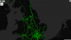
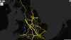
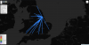
Attached are some old images I had of previous analytics showing movements of passenger and freight trains within a timetable. The other two show where freight comes/goes at Felixstowe and Immingham.
The movements shows that there's decent enough traffic on the following lines:
https://railmap.azurewebsites.net
I'm hoping to make more publicly available maps and charts. What analytics would people generally like to see?
So far:
- Loading Gauge Map
- Breakdown % of gauges + total track kilometres
- Electrification Map
- Breakdown % of type (OHLE, DC3, DC4, etc)
- Historical changes and progress (thanks to Gralistair for providing the data)
- More maps:
- Route Availability, Length/Weight restrictions, include gauge certificates on gauge map.
- Electrification:
- Adding schedule overlay onto the map to aid in analysing what routes should be next and how much CO2 it could save.
- Historical Delays Map
- A line chart with total per day and when a point is clicked on, it shows a breakdown by reason (pie chart)
- Today's delay
- Show delays so far today and potential knock-on delays.
- Schedules
- Pick a schedule current or historical schedule and map it.
- Total distance travelled and CO2 used/saved?
Is there any maps or analytics that you think I can create/share?
Attached are some old images I had of previous analytics showing movements of passenger and freight trains within a timetable. The other two show where freight comes/goes at Felixstowe and Immingham.
The movements shows that there's decent enough traffic on the following lines:
- Transpennine (Passenger)
- Bristol to Birmingham via Worcester (Passenger)
- Cardiff to Swansea (Passenger)
- Immingham to Doncaster (Freight)
- Felixstowe to Crewe (Freight)
Attachments

Last edited: