Hi all,
Are there any (public) maps of railway line gradients anywhere?
I'm thinking of something along the lines of the attached image, with distance down the line on the x-axis, height above sea level on the y-axis, and the positions of stations (and perhaps other interesting locations) indicated.
Thanks
Ian
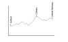