• Our booking engine at tickets.railforums.co.uk (powered by TrainSplit) helps support the running of the forum with every ticket purchase! Find out more and ask any questions/give us feedback in this thread!

Trivia - abandoned railways with intact track

Status
Not open for further replies.

Bedpan

Established Member
Joined
4 Feb 2010
Messages
1,287
Location
Harpenden
Geoff Marshall covered that exact line in his latest video! Worth a watch.
He also commented that the original cutting had been filled in before the short length of track was put in position.

I'll second that the series on London's Lost Railways that he is doing at the moment is very much worth a watch. The episode before West Drayton to Uxbridge was West Drayton to Staines West and showed some overgrown track at the Staines end, possibly where the link to the Windsor branch was constructed to allow continued access to the Staines oil terminal after the M25 was built. (Apologies if this has been mentioned earlier).
 
Sponsor Post - registered members do not see these adverts; click here to register, or click here to log in
R

RailUK Forums

route101

Established Member
Joined
16 May 2010
Messages
10,612
There is a branch out near Glenrothes around Kingslassie that still has track intact, anyone know when this was last used?
 

najaB

Veteran Member
Joined
28 Aug 2011
Messages
30,783
Location
Scotland
There is a branch out near Glenrothes around Kingslassie that still has track intact, anyone know when this was last used?
I believe it was associated with the opencast coal mine in the area. That closed a decade or so ago so I'd assume the line hasn't been used since.

Edit: It was longer ago than that - mid to late 1990s from what I can see.
Further edit: Railscot has the answer. Closed in 1998, reopened again in 2008 and closed shortly thereafter.
 

Jon_jpwh

Member
Joined
14 Jan 2021
Messages
24
Location
St Leonards on Sea
Does platform 7 at Norwood Junction qualify. The track is still there but it isn't used.

Also the Eastbound track from East Putney between the remains of the flyover and Point Pleasant Junction. Part of the track is just visible on Google Satellite.
 

Mitchei

Member
Joined
16 Feb 2021
Messages
5
Location
Ardrossan
Photograph taken 15/04/2021 of the line from Barrmill in North Ayrshire to the MOD Munitions Depot at Beith. This line last run a scheduled train in 1996, although it was used for an emergency exercise in 2000. It was disconnected from the main line in 2008 when the junction at Lugton was lifted during track doubling work. Most of the track is very heavily overgrown, with the photo being taken where most people access the line for walking purposes, therefore there is less growth. The line was once part of the Lanarkshire and Ayrshire Railway with the former Giffen station about half a mile from where I took the photo. The platforms at Giffen are still intact.
 

Attachments

  • Barrmill 1.jpg
    Barrmill 1.jpg
    133.6 KB · Views: 88

james60059

Member
Joined
6 Jul 2006
Messages
839
Location
Hinckley
I seen a cab ride on YouTube taking in the Grimsby Light Railway, and the line into Grimsby Docks is still extant albeit out of use, also there was an annotation of going into a ti-oxide place, again track extant bit out of use.

Full credit to RailMart
 

Doppelganger

Member
Joined
27 Jun 2011
Messages
397
yes the Chatham Dockyard branch, stops just short of the Asda at The Strand, no idea when the last train ran down there or even used it as a siding
Definitely still running into the 1990s. They used the trains to remove a very large quantity of contaminated soil in the redevelopment of St Mary's Island for housing purposes.
 

ejstubbs

Member
Joined
19 May 2016
Messages
206
Location
Scotland
I remember the old tracks still in place nearer Loanhead on the other side of the Bypass. Surely you could walk across the border! I never notice these local authority borders!

Until yesterday it was illegal to leave ones home local authority, with certain exceptions. One of which was to take exercise, so last Wednesday I rode my bike along the cycle path from Lasswade Road to Shawfair (avoiding the border guards as I crossed in to Midlothian ;)) and had a nosy around Millerhill village. The tracks visible in the 2012 Streetview photos are very much still there.

DSC_2939.png

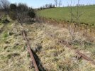
This is the buffer stop where the track stops just short of the old alignment of Millerhill Road. The track here runs through a field and although lined with mature hedgerows on each side it's not really fenced in any effective way.

DSC_2942.png

Signal EM41, which is just about visible in the previous photo, close up here showing it still illuminated. The turnout is a score or so of yards further along.

DSC_2945.png

Looking north from the B6415 overbridge towards Millerhill 'yard'. There's a 5mph speed restriction sign hidden in the trees to the left of the track. I think the road (which is gated on the other side of the overbridge) leads to the DB Schenker part of the yard (if indeed that is still what it is).

DSC_2948.png

Same overbridge, looking south. There is another illuminated signal up there but I couldn't get close enough to see its number.

DSC_2951.png

This photo was taken from an overbridge for an unsurfaced track called "The Kaims", which runs from the roundabout on the A6106 south of Newton Village and emerges on to the Old Dalkeith Road about 250m south-east of the park-and-ride. The remains of the trackbed west of Millerhill Road can be seen; there are no tracks still in situ on this stretch.

DSC_2953.png

Looking west from the same overbridge towards Shawfair. Again, no tracks in situ here.

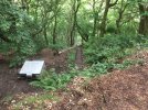
The cycle path from Glencorse/Roslin/Loanhead/Straiton emerges on to the main road through Shawfair (which appears not to have a name, even on the council's own map) at the slightly bizarre little cluster of 'artworks' here. Behind the camera is the other end of the bit of trackbed shown above; for some reason it's obscured in the Streetview image but in any case it's only really identifiable from the road by the hedgerows on each side heading east across the fields.
 
Last edited:

Railperf

Established Member
Joined
30 Oct 2017
Messages
2,941
Folkestone harbour branch..track seemingly all the way including the pedestrian area throuhh the old station along the pier.
 

87007

Member
Joined
22 Jun 2013
Messages
29
Assuming no changes since "Covid", St. Helens Central to near the site of Sutton Oak mpd is still in situ. Last traffic was to the former Hayes Chemicals factory. A fence has been built across the track at the St. Helens end, and there is heavy vegetation growth between the rails. (The continuation to St. Helens Junction & Widnes was removed many years ago.)


Grid56005

Member
Joined
7 Jul 2017
Messages
33
Regarding Quidhampton, I see from this Friday 23/4 that RTT has train paths booked there, although they are only Q ones at present, HS2 related?
 

aar0

Member
Joined
13 Sep 2016
Messages
300
I believe both RN bases in Portsmouth and Plymouth have standard gauge lines set into the roads, unused for quite some time.
 

Dr_Paul

Established Member
Joined
3 Sep 2013
Messages
1,358
I believe both RN bases in Portsmouth and Plymouth have standard gauge lines set into the roads, unused for quite some time.
Most major RN bases had a railway connection; unfortunately, the navy was very shy about having any details of their bases on OS maps (the army didn't seem to mind having details of their bases shown), and so they're not much use for ascertaining track-plans inside the bases.
 

leezer3

Member
Joined
24 Jan 2006
Messages
95
Location
Cornwall/ Norwich
I believe both RN bases in Portsmouth and Plymouth have standard gauge lines set into the roads, unused for quite some time.

Full details / plans of this are in
Larry Crosier's Mechanical Signalling in Plymouth (SRS).

Pretty extensive system going to all the main basins etc.
 

Marvin

Member
Joined
7 Jul 2011
Messages
120
Similar area: the Kingswinford branch had lots of rail on it as well, although I admit that's before I moved down here almost 9 years ago!!! I seem to recall there was a programme of vegetation clearance in the Moor St/Leys Road area which got some folk excited - perhaps the rail went with that. Not sure anything survived north of the canal bridge, in any case.

The track is still in place (or was a couple of weeks ago!) from the canal bridge to the site of Pensnett Halt - there's even a passing loop just south of Pensnett, hiding away in the trees! Track is also still in place from south of the canal bridge to beyond Brockmoor Halt, I don't know how close it gets to the main line itself but I suspect the answer is "pretty darn close".

The track on the old South Staffordshire line between Dudley and Wednesbury has gone so that it can be replaced by the Metro and/or the VLR centre, but from Wednesbury Town station north to Walsall it's still there.
 

Wilts Wanderer

Established Member
Joined
21 Nov 2016
Messages
2,484
Regarding Quidhampton, I see from this Friday 23/4 that RTT has train paths booked there, although they are only Q ones at present, HS2 related?

Not sure what they’re for, but there is definitely a resumption of interest in Quidhampton sidings as a freight terminal. Discussions have been had within NR about the methods of working for shunting trains in/out of the terminal, as it can restrict movements on the adjacent main running lines depending on the number of operational staff provided.
 

Dan17H

Member
Joined
14 Nov 2020
Messages
55
Location
Essex
The old Folkestone Harbour Branch still has track in most places, the Viaduct is still inspected and I believe the bridge through the marina.

The station has been converted now.
 

Steve Harris

Member
Joined
11 Dec 2016
Messages
895
Location
ECML
The old Folkestone Harbour Branch still has track in most places, the Viaduct is still inspected and I believe the bridge through the marina.

The station has been converted now.
And the Folkstone Harbour branch has been mentioned 3 times already in this thread. Your post being the fourth ! This post being the 5th !! (And I somehow suspect it won't be the last post about this particular line).
 

yorksrob

Veteran Member
Joined
6 Aug 2009
Messages
38,942
Location
Yorks
Hopefully we’re going there for a weekend in May.
Is there still some remaining track then..?

There is - you can wander up and down on it (not a patch on traversing it on a slammer though !)

But I grew up near Folkestone and visit every so often and still love the place !

Think I was on the penultimate passenger train to the harbour in 2008.
 

Old Yard Dog

Established Member
Joined
21 Aug 2011
Messages
1,480
In 1937 the Staffordshire Potteries Water Board gained authority for the erection of pumping stations at Peckforton and Tower Wood in Cheshire, with a reservoir on Bulkeley Hill, from where the water would gravitate to a large storage reservoir at Cooper’s Green, near Audley, for distribution to Tunstall and the Potteries.


Most of these enterprises were held up by the Second World War and it wasn't until 1953 that the Peckforton scheme and its linking aqueduct to Audley were completed. There are two boreholes where water is pumped from the Sherwood Sandstone aquifer which is near to the surface: close to the Copper Mine Inn (since renamed the Sandstone) with three pumping stations, and at Peckforton Gap. There is a holding reservoir at the Gap, from where water is pumped up 360 ft to a covered reservoir on Bulkeley Hill at 690 ft above sea level. From there a 27 inch steel pipe feeds the water under gravity to the reservoir at Cooper’s Green, Audley, 460 ft above sea level.


The Bulkeley Hill railway was the hauled tramway used in the construction of the Bulkeley Hill reservoir and water main, including a massive anti-surge valve at the top of the tramway.

This steep narrow-gauge track, about 5.2 ch in length, was built solely to carry heavy components to the summit during the construction of the surge regulator in 1949. There are foundations for a haulage engine at the top of the line. This view is looking downhill from the top of the line.


The top of the tramway is on the Sandstone Trail long distance footpath (OS 526553).
 

Attachments

  • IMG_1631.JPG
    IMG_1631.JPG
    4.9 MB · Views: 48

Jamesrob637

Established Member
Joined
12 Aug 2016
Messages
5,232
The Oldham Loop line before it was converted to Metrolink. Bits of old track on the A62.
 

Rail Ranger

Member
Joined
20 Feb 2014
Messages
590
The flat crossing at Mumps was actually Metrolink track. The railway was on a viaduct at that point.
 
Status
Not open for further replies.

Top