• Our booking engine at tickets.railforums.co.uk (powered by TrainSplit) helps support the running of the forum with every ticket purchase! Find out more and ask any questions/give us feedback in this thread!

[Trivia] Worst Bus Map

Status
Not open for further replies.

tbtc

Veteran Member
Joined
16 Dec 2008
Messages
17,882
Location
Reston City Centre
What is the worst bus map (at the moment, historically)?

It's all subjective, of course, but I'd consider things like:

  • Too many colours
  • Not enough colours, so it's confusing which "red" line is which
  • Too many lines
  • Too schematic, so no relation to reality
  • Insufficient information to work out where services terminate or names of intermediate roads
  • Too much information, crowding out the flow of services, making it hard to read (e.g. text superimposed upon roads)
  • No distinction between "frequent" services and "one a day" journeys

I'm asking after finding Diamond's map of their Greater Bolton operations - https://www.diamondbuses.com/media/3085/map.pdf - personally I don't mind geographic or schematic maps, but if you're going schematic then I'd want a bit more detail

  • lots of routes go between multiple "nodes" but the number often only shows once, so you struggle to see whether the one that continues is the brown or the bronze or the orange line (since there are several colours which means some similarities, it's hard to follow, because the lines don't have numbers on them so you can't be sure which of the darkish-blues follows on beyond a junction) - for example there are four routes from Bolton to Farnworth but I need to trace them much further to find out what numbers they have
  • there must be a few services terminating at places like Trafford Centre but not the traditional "number in a box" to indicate that a service terminates there
  • none of the lines are bolder/thinner to indicate frequent/irregular services other than a couple of "eve" services in the top left corner
  • there's lots of straight lines to make things look very "simple" but then certain areas have "accurate" looking squiggles (Altricham, Bury), the combination looks like the worst of both worlds

It's probably not the worst out there (and some of the above is obviously entirely subjective, my own personal prejudices etc), but I'll use the Diamond one as a benchmark - can you find a worse one? (2021 map or historic one, each are valid)

As a better example, the Travel South Yorkshire map (https://travelsouthyorkshire.com/ge.../Sheffield-Network-Map-valid-October-2021.pdf) has clearly different colours, regular numbers along the course of a route, areas with very high frequencies have a big "grey" line rather than distorting the map by trying to have ten parallel lines on the one road, irregular services are all light grey, it's pretty accurate geographically)

Obviously any map depends on just how complicated/simple a network is, some areas are easier to replicate, other areas have messy combinations of irregular route variations or several services along one common road which distorts the map.... you can only do a map based on what you have and some networks are tidier than others!
 
Sponsor Post - registered members do not see these adverts; click here to register, or click here to log in
R

RailUK Forums

tbtc

Veteran Member
Joined
16 Dec 2008
Messages
17,882
Location
Reston City Centre

Wow, that looks like a doodle on the back of a beer mat that someone has scrawled out!

Maybe if you're familiar with Barnstaple then all of the loops and twists will mean something but that looks a real mess and nothing to explain the roads etc - a shame, as the "main" bit of the map is perfectly clear, I'd feel confident enough getting round long distances in North Devon but uncertain about how to get around the (smaller) Barnstaple!
 

Flange Squeal

Established Member
Joined
17 Jul 2012
Messages
1,260
I'm not particularly keen on the new Stagecoach Woking map. The use of either very pale colours on a white background (47 on western edge, pale pink/light green 39A/39B across middle) are quite hard to see - you've really got to look for them! The various bolder greens I feel blend in with the green ticket boundary and various parks/green spaces too much. It comes across a bit "busy" to me. Some of these routes cross onto the Guildford map (34/35) so making sure those remain that colour and don't clash with other routes makes sense, but no reason that some of the more bold colours used solely within the Guildford map couldn't also be used on the Woking map, as there is already some duplication on the separate maps (eg Woking 91 and Guildford 71 both being red). It also can't be to avoid duplication and retain 'flow' with the neighbouring Blackwater Valley map either, as the 34/35 and 520 all change colour as they cross between the two maps.


-

White Bus are an operator I generally praise in terms of fleet, timetable material and website (full fare charts etc). Their network map just being lines of green with route numbers could perhaps do with each route being a different colour, or at least seperate/adjacent lines, to be easier to follow though.


Simon75

On Moderation
Joined
25 May 2016
Messages
890
As a better example, the Travel South Yorkshire map (https://travelsouthyorkshire.com/ge.../Sheffield-Network-Map-valid-October-2021.pdf) has clearly different colours, regular numbers along the course of a route, areas with very high frequencies have a big "grey" line rather than distorting the map by trying to have ten parallel lines on the one road, irregular services are all light grey, it's pretty accurate geographically
That type of map has been in use for about 40 years , by various operators, which as you say its easy to understand
 

TheGrandWazoo

Veteran Member
Joined
18 Feb 2013
Messages
20,028
Location
Somerset with international travel (e.g. across th
Wow, that looks like a doodle on the back of a beer mat that someone has scrawled out!

Maybe if you're familiar with Barnstaple then all of the loops and twists will mean something but that looks a real mess and nothing to explain the roads etc - a shame, as the "main" bit of the map is perfectly clear, I'd feel confident enough getting round long distances in North Devon but uncertain about how to get around the (smaller) Barnstaple!
The new Stagecoach maps for Devon are all rubbish.
 

Wolvercoter

Member
Joined
29 Sep 2010
Messages
489
Location
Exeter, Devon

And I thought the Exeter one was bad - the Barnstaple one looks incomplete - would be much better with some labelling!

That said, Exeter City's map is very poor, even with labelling. Lots of inconsistencies, omissions and errors (e.g. T in Topsham shows it going over the railway crossing which it doesn't, 2/2B/B routeings are wrong and also misleading in Exminster, the St Davids area doesn't show anything useful.)

It's a shame as they used to produce a good, detailed map for Exeter and other areas in Devon.


ExeterNetwork.pdf (tiscon-maps-stagecoachbus.s3.amazonaws.com)
 

Megafuss

Member
Joined
5 May 2018
Messages
644
It is impressive how they've got Chepstow and Beachley to appear closer to Bristol than Avonmouth and Severn Beach which would put them the wrong side of the river. Plus ignoring their Wotton to Yate services!
I thought it was a map of the stars when I first looked at it
 

Welly

Member
Joined
15 Nov 2013
Messages
499
There is no point in having a bus route map that completely omit the roads/streets they run through! The Sheffield bus map is a very nice one and I wish more cities have bus route maps like that!
 

jammy36

Member
Joined
28 Aug 2013
Messages
299
The new Stagecoach maps for Devon are all rubbish.

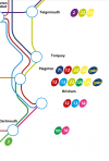
Yes, the Devon maps are truly awful, including the overall network map. Extracts below to illustrate - there seems to be something very wrong with the position of the route numbers in relation to the placenames - so the 7A, 12, 22, 122 & gold listed next to Paignton should be Torquay, whilst the random 120 & 18 floating in the sea should be at Dartmouth. Also, why is there no yellow line for the 122 and does gold run to Torquay? If so, why does the gold line stop at Paignton?
Screenshot_20211231-193853-237.png

Similarly does the top blue circle represent Ottery St Mary or Honiton & is the one to the south Sidmouth or Budleigh Salterton (and if the latter do the 58 and 357 go there...). Good luck working that out if you don't know Devon's bus routes and geography!
Screenshot_20211231-193821-244.png
 

Llandudno

Established Member
Joined
25 Dec 2014
Messages
2,197
It’s good to see that there are still some operators producing a printed route map.

Needless to say Arriva Buses Wales produces neither a map nor printed timetables and this in area with lots of tourists not familiar with the bus routes on offer.

I guess you could refer to the user friendly Arriva website!!
 

geoffk

Established Member
Joined
4 Aug 2010
Messages
3,243
Yes, the Devon maps are truly awful, including the overall network map. Extracts below to illustrate - there seems to be something very wrong with the position of the route numbers in relation to the placenames - so the 7A, 12, 22, 122 & gold listed next to Paignton should be Torquay, whilst the random 120 & 18 floating in the sea should be at Dartmouth. Also, why is there no yellow line for the 122 and does gold run to Torquay? If so, why does the gold line stop at Paignton?
View attachment 108059

Similarly does the top blue circle represent Ottery St Mary or Honiton & is the one to the south Sidmouth or Budleigh Salterton (and if the latter do the 58 and 357 go there...). Good luck working that out if you don't know Devon's bus routes and geography!
View attachment 108060
Yes. I'm in the Exeter Bus User Group and we've made the point to Stagecoach in a friendly way that this style of map is not what's needed in a city which attracts tourists and large numbers of students, not to mention local residents. We hope for an improvement.
 

GatwickDepress

Established Member
Joined
14 Jan 2013
Messages
2,288
Location
Leeds
East Sussex County Council have an online map which isn't too bad to use, although it's very slow, text doesn't always scale properly, and it can be difficult to discern route numbers. I do like how clicking on a route will bring up the option of a simple PDF timetable though.
 

Wolvercoter

Member
Joined
29 Sep 2010
Messages
489
Location
Exeter, Devon
Yes. I'm in the Exeter Bus User Group and we've made the point to Stagecoach in a friendly way that this style of map is not what's needed in a city which attracts tourists and large numbers of students, not to mention local residents. We hope for an improvement.

Just an update, Stagecoach South West have published new maps on their website for Exeter, North Devon, Plymouth, Torbay and the wider network. Much improved quality!
 

Darklord8899

Member
Joined
6 Jul 2018
Messages
679
Yes, the Devon maps are truly awful, including the overall network map. Extracts below to illustrate - there seems to be something very wrong with the position of the route numbers in relation to the placenames - so the 7A, 12, 22, 122 & gold listed next to Paignton should be Torquay, whilst the random 120 & 18 floating in the sea should be at Dartmouth. Also, why is there no yellow line for the 122 and does gold run to Torquay? If so, why does the gold line stop at Paignton?
View attachment 108059

Similarly does the top blue circle represent Ottery St Mary or Honiton & is the one to the south Sidmouth or Budleigh Salterton (and if the latter do the 58 and 357 go there...). Good luck working that out if you don't know Devon's bus routes and geography!
View attachment 108060
I am not familiar with Devon at all (I live in Scotland) and I can confirm that those maps leave me even more confused and with more questions than they should!
 

pdeaves

Established Member
Joined
14 Sep 2014
Messages
5,631
Location
Gateway to the South West
To me as a mere user, I think this one has both good and bad bits. The good: it is possible to see which of potentially many routes a bus takes to get from main place to main place. The bad: what happens actually in the main place? I want to know where I will end up and/or where to go to catch any given bus.
 

S&CLER

Member
Joined
11 Jan 2020
Messages
785
Location
southport
East Sussex County Council have an online map which isn't too bad to use, although it's very slow, text doesn't always scale properly, and it can be difficult to discern route numbers. I do like how clicking on a route will bring up the option of a simple PDF timetable though.
Many thanks for this tip; I shall be in Eastbourne next week and have found the site very useful, especially for printing out the relevant PDF timetables.
 

railwaytrack

Member
Joined
7 Mar 2022
Messages
254
Location
Pluckley
East Sussex County Council have an online map which isn't too bad to use, although it's very slow, text doesn't always scale properly, and it can be difficult to discern route numbers. I do like how clicking on a route will bring up the option of a simple PDF timetable though.
Many thanks for this tip; I shall be in Eastbourne next week and have found the site very useful, especially for printing out the relevant PDF timetables.
Also note that East Sussex County Council still produce current up to date PDF maps of all 13 maps (the 1 county wide map and the 12 town maps) which are available here:


So these PDF are very useful if you prefer them to the interactive map or if you want to print out the PDF maps to take with you on a journey.
 
Last edited by a moderator:

duncanp

Established Member
Joined
16 Aug 2012
Messages
4,856
I recently visited Dubrovnik and the bus map doesn't even compare to any of the examples in this thread: https://www.libertasdubrovnik.hr/lines-map/

I think this one for Lille in France is quite good.

All the bus, tram and metro routes are clearly shown.


For cities where the network is too large to show everything on one map, you can produce maps for local areas, such as New York, where there is a separate bus map for each of the five boroughs.

Whilst online journey planners are useful, a map can show the network in a way that a journey planner can't. (ie. which bus routes go to a particular area, or how the bus routes intersect with each other.
 

mike57

Established Member
Joined
13 Mar 2015
Messages
1,658
Location
East coast of Yorkshire
Whilst online journey planners are useful, a map can show the network in a way that a journey planner can't. (ie. which bus routes go to a particular area, or how the bus routes intersect with each other.
An online planner is poor at answering the question 'These are these places I want to visit, what is the best order to do it?' This is where maps score, and you can often add 'Oh and we pass place X, may be stop there as well' A planner tends to assume you are doing a point to point journey.

I mourn the passing of the old London bus maps, you could very quickly plan an intersting route taking in the places you want to visit, much more difficult with the latest TFL offerings.
 

Hophead

Established Member
Joined
5 Apr 2013
Messages
1,193
It's the difference between saying "I know where I want to go and when - help me out" and "what's out there and how does it all relate?".
 

Statto

Established Member
Joined
8 Feb 2011
Messages
3,213
Location
At home or at the pub
When operators publish a map, but leave out the Town or City Centre, Arriva & Stagecoach are bad for this.

Take a look at Arriva Shrewsbury, which is decent map, is a geographical map, with routes in the outer suburbs printed, but they don't have routes in the Town Centre, considering the bus station is a bit of a hike from the Town Centre

Arriva Shrewsbury Map


Another thing, probably just me, i hate schematic bus maps full stop, i find it lazy way of publishing bus maps, they're ok for rail, but i'd rather a geographical map published for bus routes, i like to find out where in relation to the place the bus route goes
 

PTR 444

Established Member
Joined
22 Aug 2019
Messages
2,282
Location
Wimborne
When operators publish a map, but leave out the Town or City Centre, Arriva & Stagecoach are bad for this.

Take a look at Arriva Shrewsbury, which is decent map, is a geographical map, with routes in the outer suburbs printed, but they don't have routes in the Town Centre, considering the bus station is a bit of a hike from the Town Centre

Arriva Shrewsbury Map


Another thing, probably just me, i hate schematic bus maps full stop, i find it lazy way of publishing bus maps, they're ok for rail, but i'd rather a geographical map published for bus routes, i like to find out where in relation to the place the bus route goes
Wilts & Dorset (predecessor to More and Salisbury Reds) used to publish separate schematic maps for their services in Bournemouth/Poole, Salisbury and the New Forest until about 2007 or so when they moved to geographical mapping.

I much prefer a geographical approach myself because you can see all routes and the location of bus stops in relation to where you are, whereas with a schematic map you only know the rough location of where the bus goes. In several cases the only way of knowing exactly which route the bus takes would be if you live locally and/or are a user of the route. Listing key stops in the timetable helps with that regard but unless every single one is listed, you still have to guess which route it might take if you don’t know the area.

And as for leaving out the town or city centre on maps, I don’t mind if it’s a rural map if there’s too much detail to be shown, but for an urban map it should definitely be included. I think a lot of publishers do this to avoid roads on the map from becoming overloaded with multiple lines where numerous bus routes meet in a town/city centre, but I think a better way of solving this issue is to simply use a black line depicting all routes and use bus stop code locators to inform the public where they need to get on/off.
 

Statto

Established Member
Joined
8 Feb 2011
Messages
3,213
Location
At home or at the pub
For me, it's when they have an outer suburb map, but no Town or City Centre map, even as a separate publication, which makes things worse, some Town or City Centres can be a bit of a hike between stops, or the main bus hub, from the main central area
 
Status
Not open for further replies.

Top