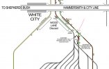
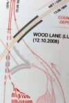
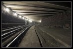
I’m guessing to an extent, but before they buried the entire 1947 westbound line in the new covered way, it must still have been running in a direction taking it gradually away from its original path through towards the old platform 4. That would presumably be the area shown in this photograph from the abandoned stations site:
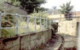
What we probably need is an aerial view of that area just before the Whits City area redevelopment. Now the inner support wall for the new covered way roof (and everything above it) would need to have much better foundations, and the obvious working method would be to build the new walls far enough away from the existing cutting to allow trains to keep running, probably within some sort of temporary safety structure. So building it outside that apparent concrete slab would be the low risk option, even if it meant it was slightly wider than needed.
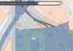
Theres an online map showing London Underground property assets and zones of influence here:

www.arcgis.com
I’ve taken a screen shot of what is clearly a widening of the present covered way here, see how after the covered way area branches southwards, (that must be the old depot westbound exit position), the east part is widening out?
This opens up another mystery, there's a junction just inside the tunnel, as the white balance alters to the dark, you can see a line going off to the left of the train (9'32"). This isn't on any maps, nor is it there any more. There doesn't appear anywhere for it to go when you see the train approaching from outside the tunnel.
Unless the train in the video is going down to point GA and G8 on the pdf diagram 1947-49. In which case it would be the westbound line coming across from the left. Which would make the tunnel the train is coming down the one that is now blocked off.
I think Inspector Clouseau would be proud of me!
I think what you‘re thinking of as a branch is just catch points and a sand drag to trap a train running away downhill from the depot exit line. Two side by side permanent red lights stood within the track bed. It’s a common safety feature - just unusual to see one underground. You can see the points are both numbered 30 in the final 1949 diagram, so act together. Distances aren’t that easy to assess in the darkness of the video, but I think the points will be much closer together than the diagram implies, given it isn’t to scale. I suspect the concrete wall they lead to behind the stop lights is possibly in line with the older Platform 4 route, but I expect it’s all buried now.
PS I had a search through the online planning applications, on Hammersmith and Fulham’s website, but unfortunately although the big projects from the time the depot was rebuilt are identifiable in the index, they don’t have any plan drawings accessible...


