• Our booking engine at tickets.railforums.co.uk (powered by TrainSplit) helps support the running of the forum with every ticket purchase! Find out more and ask any questions/give us feedback in this thread!

Walking and Rambling discussion

S&CLER

Member
Joined
11 Jan 2020
Messages
785
Location
southport
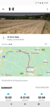
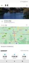
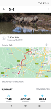
Last week on that blazing hot Sunday, I led a no. 2 walk from the site of the former Hartside Top café on the A686, between Penrith and Alston, down to Melmerby. The walk was planned to be nearly all downhill, and we set off down a bridleway, surprisingly wet in places, to Selah Bridge and on to Haresceugh, across fields and down to Raven beck, briefly along it to a footbridge then across a field to Raven Beck Bridge. From there we walked back to the bridleway we had been on before, on to Busk, through a farm and down to the lane north of the village of Unthank. From there we turned up to Hazel Rigg, then across fields by paths to the pleasant village of Gamblesby, sheltering from the heat in the bus shelter. We then continued along narrow but shaded tracks to Melmerby and the very agreeable Shepherds Inn, where even Somersby cider on ice was acceptable on such a hot day. The no 1 walkers had also got off at Hartside and made the error of attempting Cross Fell, but had to give up because of exhaustion. By 5 pm they still had not arrived at Melmerby, and the coach was due to leave Alston with the no. 3 and 4 groups at 5.15. As it was, the coach reached Melmerby around 5.40 and had to wait 20 minutes for the no. 1 group to turn up, with no time for them to have a drink. Oddly, this was the second time this had happened in the same place, and two of the people who had been on that previous walk were also in this one; they feel that they are doomed never to see the inside of the Melmerby pub. The real problem on that hot day was the flies. Maybe the Eden valley is just unlucky for me, but the last walk I had which was so fly-ridden was in the same general area, from Wetheral station to Armathwaite station.
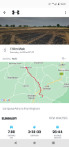
I can also recommend a walk from Langwathby to Daleraven bridge on the Eden via Long Meg stone circle, returning to Langwathby by the river bank, passing the former Long Meg sidings, which in the 1960s sent out 9F-hauled trains of anhydrite to Widnes, and Little Salkeld; or possibly continuing to Lazonby and coming back to Langwathby by train.

I'm down with Covid at the moment, so can't go out today, but hope to recover in time to lead a 9-mile walk from Wardlow Mire to Eyam via Silly Dale, Grindlow, Hucklow Edge, the Barrel pub, Bretton Clough, Stoke Ford, Hazelford, Eyam Moor and Sir William Hill Road, next Sunday.
 
Sponsor Post - registered members do not see these adverts; click here to register, or click here to log in
R

RailUK Forums

32475

Member
Joined
2 Nov 2019
Messages
740
Location
Sandwich
I hadn’t come across the Walking and Rambling section before so that’s a good topic to find. I’ll be walking the West Highland Way later next month so expect a few reports from there!
Meanwhile, my local regular walk takes me past Richborough Castle near Sandwich. The route goes over two occupation crossings where these signs have been erected. I can’t help thinking that during industrial action, if nobody is going to pick the phone up then the chance of any trains running is just as unlikely. Any thoughts anyone?2050E90D-C475-461D-993F-8AF381BBE33A.jpeg
 

THC

Member
Joined
21 Sep 2009
Messages
471
Location
Stuck on the GEML
I had planned to walk along the Staffs & Worcs Canal and the Severn Way from Stafford to Worcester over the weekend finishing today but the heatwave put paid to that. So I walked 22 miles from Stafford to Wolverhampton on Friday and 18 miles from Wolves to Kinver on Saturday, where a selection of cracking pubs made any further progress nigh on impossible. :E

THC
 

Attachments

  • Screenshot_20220715-192431.png
    Screenshot_20220715-192431.png
    1.2 MB · Views: 9
  • Screenshot_20220716-184826.png
    Screenshot_20220716-184826.png
    1.5 MB · Views: 9

Kite159

Veteran Member
Joined
27 Jan 2014
Messages
19,257
Location
West of Andover
Nice with those distances:)

I did a few more shorter walks over the weekend, Friday was from Abergele & Pensarn towards Prestatyn along the coastal path (which was very nice in places, other times you couldn't see much due to a large rock embankment or hedges). (9.3)

Followed by a little loop around Chester (went south from station via Grosvenor Park to the River Dee for the "Riverside path" towards the canal before the towpath back towards the station area. Some nice river views at the start but most of the time the river was hidden from view behind trees. (4 miles)

Saturday was a random walk from Frodsham towards Helsby, featuring various footpaths, including one which followed the River Weaver which was very overgrown, then some footpaths which exists on the map but not in real life (the stile might have been there but no evidence where the path went) (9.1)

4th was another section of the Weaver, this time from Winsford towards Northwich, a nice path along the river, quiet in places with some industry. Although the WCML bridge was a bit of a let down due to no decent views due to trees. (8.5 miles)

On the Sunday I was toying with walking from Aston towards Snow Hill in Birmingham, but a mix of the warmth & cancellations put a stop to that.
 

THC

Member
Joined
21 Sep 2009
Messages
471
Location
Stuck on the GEML
Chelmsford to Great Dunmow. 19 miles of the Saffron Trail footpath on a hot summer's day. Dunmow is a very charming town indeed even if the railway no longer serves it.

THC
 

Attachments

  • Screenshot_20220724-153835.png
    Screenshot_20220724-153835.png
    1.3 MB · Views: 9

Kite159

Veteran Member
Joined
27 Jan 2014
Messages
19,257
Location
West of Andover
Good going there THC :)

I ended up doing a near 19 mile walk from Ash Vale to Hook along the Basingstoke Canal, then attempting to reach Hook on some footpaths to avoid the main roads. I do like the Basingstoke Canal as it is very pretty in places, mainly when the trees form a canopy
 
Last edited:

philjo

Established Member
Joined
9 Jun 2009
Messages
2,892
some members of our local walking group walked Lady Anne’s Way earlier this month, 100 miles from Skipton to Penrith. We did it over 8 days. Staying in Skipton, Grassington, Hawes, Ravenstonedale and Appleby en route with luggage transfer and booked taxi shuttles as we were staying 2 nights in some places. Good views of the Settle &Carlisle line along Mallerstang, including seeing a triple header freight. The last day into Penrith was the least interesting- the route of the last day included a couple of very long straight road sections.
 

THC

Member
Joined
21 Sep 2009
Messages
471
Location
Stuck on the GEML
Good going there THC :)

I ended up doing a near 19 mile walk from Ash Vale to Hook along the Basingstoke Canal, then attempting to reach Hook on some footpaths to avoid the main roads. I do like the Basingstoke Canal as it is very pretty in places, mainly when the trees form a canopy
The Basy is a lovely walk indeed, especially on the very western stretch to Greywell tunnel. It's worth pushing on to Old Basing to see where the canal finished - the line can be traced for at least a couple of miles on the far side of the tunnel.

--

Wickham Market (station) to Framlingham. Eight miles along the East Suffolk Line waymarked walk to Fram, with all three original stations visited en route. And a return to the start on the excellent Katch bus-taxi, which would have provided seamless integration with the train had it not been a rail strike day. :E

THC
 

Attachments

  • Screenshot_20220730-160139.png
    Screenshot_20220730-160139.png
    1.1 MB · Views: 5
Last edited:

Kite159

Veteran Member
Joined
27 Jan 2014
Messages
19,257
Location
West of Andover
The Basy is a lovely walk indeed, especially on the very western stretch to Greywell tunnel. It's worth pushing on to Old Basing to see where the canal finished - the line can be traced for at least a couple of miles on the far side of the tunnel.

--

Wickham Market (station) to Framlingham. Eight miles along the East Suffolk Line waymarked walk to Fram, with all three original stations visited en route. And a return to the start on the excellent Katch bus-taxi, which would have provided excellent integration with the train had it not been a rail strike day. :E

THC

Hook to Basingstoke is on my list to do at some point before the year ends.
 

Kite159

Veteran Member
Joined
27 Jan 2014
Messages
19,257
Location
West of Andover
I noticed when using my Strava app yesterday to record my walk along the Bristol - Bath Railway Path that a recent update seems to have made the map appear more 3D and also seems to ignore the setting to lock the map so North is at the top (basically tries to guess which way the phone is pointing and spins it so it is straight on the phone). Something I find is rather annoying as I like my maps locked.

Also I've noticed whenever I pause the walk, whereas before where I was on the map would be centre of the screen, it seems to be at the bottom part of the screen (and covered by the summary).

Anybody got any other recording app recommendations that I can try assuming Strava doesn't improve?
 

THC

Member
Joined
21 Sep 2009
Messages
471
Location
Stuck on the GEML
Anybody got any other recording app recommendations that I can try assuming Strava doesn't improve?
I use Map My Walk, which is not without occasional glitches but usually quite stable.

--

Mistley to Harwich. Fifteen miles to finish the Essex Way footpath for the third time. No sampling the many taverns of old Harwich on this occasion but straight to Town station instead for a Dusty Bin back to Manningtree. :E

THC
 

Attachments

  • Screenshot_20220807-174913.png
    Screenshot_20220807-174913.png
    825.5 KB · Views: 4
Last edited:

S&CLER

Member
Joined
11 Jan 2020
Messages
785
Location
southport
I enjoyed most (6.5 miles) of a good walk with the Ramblers from Betws y Coed to Dolwyddelan last Sunday in temperatures of 31 C. Fortunately the early part of the walk, where most of the climbing was concentrated, was in tree-lined shade. We left Betws and walked along the river Llugwy as far as the Miners' Bridge, crossed over, crossed the road and went up the track known as Sarn Helen, a steady grind up a stony surface. We then came down to the A470 at the bridge over the river Lledr and turned right past Pont y Pant station, a remarkably busy narrow lane. There are good tracks paralleling the railway as far as Dolwyddelan station and on to Roman Bridge. At Dolwyddelan, I decided that I didn't have enough water left to do the remaining 3.5 mile loop round to Roman Bridge and Dolwyddelan castle in comfort. Indeed the leader didn't do his full plan, but just did a shorter loop to avoid a final climb to the castle.
The real disappointment of the day was finding that the Gwydyr pub in Dolwyddelan was closed because they had no draught beer. They had bottled beer, soft drinks, wines, spirits, tea and coffee,but still refused to open for our party of 44. The Elen's Castle Hotel didn't open until 5.30, when we were supposed to leave. Fortunately the Spar shop in the village had plenty of cold drinks in the fridge and ice cream.
 

Acey

Member
Joined
16 Nov 2018
Messages
254
Last walk I did was from Southease to Eastbourne along the South Downs Way, finishing with the Seven Sisters. Living where I do it is fairly easy to walk linear sections of the SDW between railway stations.
Done the SDW twice in this way,travelling down from London,some sections quite long ( Lewes-Eastbourne) ,some not so,very enjoyable though ! -ps little known fact that the deadliest avalanche in the UK occurred at Lewes ,8 lives sadly lost
 

Mcr Warrior

Veteran Member
Joined
8 Jan 2009
Messages
11,801
Done the SDW twice in this way,travelling down from London,some sections quite long ( Lewes-Eastbourne) ,some not so,very enjoyable though ! -ps little known fact that the deadliest avalanche in the UK occurred at Lewes ,8 lives sadly lost
The course of the South Downs Way doesn't pass through Lewes / the site of the 1836 avalanche, does it?
 

Acey

Member
Joined
16 Nov 2018
Messages
254
The course of the South Downs Way doesn't pass through Lewes / the site of the 1836 avalanche, does it?
Well not quite.we walked from Lewes to Mt Caburn then over to Beddingham Towers to join the SDW ,the stations were not always close to the course of the route !
 

Mcr Warrior

Veteran Member
Joined
8 Jan 2009
Messages
11,801
...the stations were not always close to the course of the route !
Indeed, but on the section of the South Downs Way to/from Eastbourne, the route does pass by immediately adjacent to Southease station on the line to Seaford.
 

Acey

Member
Joined
16 Nov 2018
Messages
254
Indeed, but on the section of the South Downs Way to/from Eastbourne, the route does pass by immediately adjacent to Southease station on the line to Seaford.
True but if I recall correctly ( it was 30 odd years ago) we left the car at Lewes and took a train back from Eastbourne !
Please tell us all about this Everest of Sussex!
Well,there's a golf course on top and you don,t need crampons for the ascent !
 
Last edited:
Joined
24 Jul 2011
Messages
443
Location
Wigan
I enjoyed most (6.5 miles) of a good walk with the Ramblers from Betws y Coed to Dolwyddelan last Sunday in temperatures of 31 C. Fortunately the early part of the walk, where most of the climbing was concentrated, was in tree-lined shade.
Have done that section of the walk myself. It's a lovely part of the world. Part the appeal (to me at least) is how leafy it is, although, I imagine train drivers on the Dyffryn Conwy line in October may disagree. :D
 

S&CLER

Member
Joined
11 Jan 2020
Messages
785
Location
southport
Just got back from Church Stretton, where I led (at short notice standing in for an injured leader) a good 8.75 mile walk with 1370 feet of climb. We left the coach by Church Stretton station, walked into town and up through Ashbrook on the road that leads to the very busy Carding Mill Valley. At the cattle grid we turned left for the much quieter Town Brook valley, and then from the top of the valley made our way by grassy tracks to the road that runs along the crest of the Long Mynd, reaching it near the Boiling Well spring. We had lunch at Pole Bank, the highest point of our walk, having got nearly all the day's climbing done in the first 80 minutes before lunch.
From Pole Bank we followed the road nearly as far as the Gliding Club, then turned downhill down Minton Batch, a very quiet wooded valley. At the foot of the valley, we headed left and slightly uphill round Shooter's Knoll on a bridleway that brought us to a gate on a lane just south of the village of Minton, then followed the lane to the more interesting village of Little Stretton, which has 2 good pubs, the Green Dragon and the Ragleth Inn.
We could have walked uphill again alongside the Owlets to avoid the road, but as everyone had had enough climbing and it was raining, we made straight for Church Stretton along Ludlow Road,and arrived at the King's Arms, a Joules pub with a very pleasant beer garden, at 4 p.m., after a walk of 4 hrs 15 minutes. Highly recommended.
 

Kite159

Veteran Member
Joined
27 Jan 2014
Messages
19,257
Location
West of Andover
Had an enjoyable walk along the old railway line from Christs Hospital towards Shalford on Friday, other than a couple less than enjoyable patches (an unexpected steep climb near the Sussex/Surrey border due to the railway going via a tunnel) and crossing a very busy main-road. Some areas were very rural and peaceful with some nice tree cover. Not much evidence of the stations, platforms at Christ's Hospital & Bramley, with another station in private ownership.

Then today I returned to the Thames Path, this time from Shepperton towards Windsor, signposts in Shepperton were a bit poor for the "Alternative route" [for those who don't want to use the ferry between Weybridge & Shepperton]. Mixed surfaces from dried dirt, loose stones, loose straw to tarmac. Some areas were busier than others and mostly well signposted, although it could be easy to miss the junctions at Datchet where the path goes along the road due to the riverfront path being lost to Windsor Castle.

Also last week, I did a last minute decision for the "Little Ouse Way" between Brandon & Thetford [weather forecast wasn't promising so played it safer with a more "undercover" walk] some nice scenery in the forests but the first section was a bit overgrown with a couple fallen trees in places. River level was down in places exposing the stoney bed, although I did miss a turning and ended up following the Harewood Way for a couple miles as the two paths come together and go off separate ways.

I was going to do a part of the canal near Littleborough last Saturday but it was just too hot.

I might have to add that Essex Way path to my large list of ideas to do at somepoint.
 

S&CLER

Member
Joined
11 Jan 2020
Messages
785
Location
southport
Had an enjoyable walk along the old railway line from Christs Hospital towards Shalford on Friday, other than a couple less than enjoyable patches (an unexpected steep climb near the Sussex/Surrey border due to the railway going via a tunnel) and crossing a very busy main-road. Some areas were very rural and peaceful with some nice tree cover. Not much evidence of the stations, platforms at Christ's Hospital & Bramley, with another station in private ownership.

Then today I returned to the Thames Path, this time from Shepperton towards Windsor, signposts in Shepperton were a bit poor for the "Alternative route" [for those who don't want to use the ferry between Weybridge & Shepperton]. Mixed surfaces from dried dirt, loose stones, loose straw to tarmac. Some areas were busier than others and mostly well signposted, although it could be easy to miss the junctions at Datchet where the path goes along the road due to the riverfront path being lost to Windsor Castle.

Also last week, I did a last minute decision for the "Little Ouse Way" between Brandon & Thetford [weather forecast wasn't promising so played it safer with a more "undercover" walk] some nice scenery in the forests but the first section was a bit overgrown with a couple fallen trees in places. River level was down in places exposing the stoney bed, although I did miss a turning and ended up following the Harewood Way for a couple miles as the two paths come together and go off separate ways.

I was going to do a part of the canal near Littleborough last Saturday but it was just too hot.

I might have to add that Essex Way path to my large list of ideas to do at somepoint.
If you are in the Littleborough area, I strongly recommend Ramsden Clough near Walsden.
 

THC

Member
Joined
21 Sep 2009
Messages
471
Location
Stuck on the GEML
Stourbridge to Gloucester - 70 miles across three days, first finishing the Staffs and Worcs Canal towpath to Stourport before joining the Severn Way via an overnighter in Tewkesbury to reach Gloucester yesterday afternoon.

THC
 

Attachments

  • Screenshot_20220821-161935.png
    Screenshot_20220821-161935.png
    1.3 MB · Views: 7
  • Screenshot_20220820-201317.png
    Screenshot_20220820-201317.png
    1.4 MB · Views: 7
  • Screenshot_20220819-191643.png
    Screenshot_20220819-191643.png
    1.5 MB · Views: 7

Iskra

Established Member
Joined
11 Jun 2014
Messages
7,932
Location
West Riding
Excellent pics,it's a good work -out isn't it?

Yes it’s very intense as it’s a fairly consistent climb all the way. We are both happy just to be able to do such a thing in the first place as we were both hospitalised this time last year in a car crash.

Some interesting things today- there was a bloke at the top playing the bagpipes in a kilt :D and another lady was walking up and down in bare feet to prove a point to her husband :D
 

AnyFile

Member
Joined
8 Mar 2016
Messages
42
Location
Milano, Italy
Meanwhile, my local regular walk takes me past Richborough Castle near Sandwich. The route goes over two occupation crossings where these signs have been erected. I can’t help thinking that during industrial action, if nobody is going to pick the phone up then the chance of any trains running is just as unlikely. Any thoughts anyone?
Probably this merit to be discussed in a more appropriate section of the forum and by some one more expert than me. However my humble opinion is that if there is a rule that a such level crossing a pedestrian/veichle must get authority by phone before crossin, they can not just put a sign saying that is you ring and get no answer thatn you can cross
 

ChrisC

Established Member
Joined
7 Oct 2018
Messages
1,608
Location
Nottinghamshire
A few weeks ago I had to take my car for its annual service to a garage on the southern outskirts of Sheffield. I left it with them for a few hours and found a really good walk which was part of a longer 15 mile circular walk called ‘The Sheffield Round’ I did the section from Graves Park past Beuachief Abbey and Abbeydale. A very pleasant and interesting walk which seemed very rural for a walk within the boundary of a major city. Quite hilly but then that’s Sheffield. It’s somewhere I must go back to and complete the whole walk including a visit to the Abbeydale Industrial Museum which wasn’t open on the day I was there.
 

Acey

Member
Joined
16 Nov 2018
Messages
254
"Yes it’s very intense as it’s a fairly consistent climb all the way. We are both happy just to be able to do such a thing in the first place as we were both hospitalised this time last year in a car crash."
Blimey ! you did well then,hope you are both fully recovered :smile:
 

johnnychips

Established Member
Joined
19 Nov 2011
Messages
3,679
Location
Sheffield
I stayed in Buxton last Saturday night and got the 65 Stagecoach East Midlands bus to Topley Pike on Sunday morning to walk down Chee Dale. This really is one of my favourite walks. I avoided the Monsal Trail as I knew it would be full of bikes and just continued down the Wye Valley on normal footpaths to Ashford. I was going to walk on to Bakewell, but a High Peak TransPeak arrived, and it was too tempting to resist.

After a couple of beers in the Rutland Arms, I got the High Peak 58 service back to Buxton, which runs via Monyash - this is the bus enthusiast equivalent of rare track - it runs twice a day on summer Sundays only.

I am 61, so I haven’t got a free pass yet, but do qualify for the Derbyshire Wayfarer concession rate of £6.70, which was excellent value for three buses.
 

Top