I did a second recce for a walk around Hathersage I have to lead on 1 May; mainly to compare the 2 routes from near Grindleford station up Padley Gorge, and also to find a drier route from near Burbage Bridge to Mitchell Field farm across Hathersage Moor. I had done the path via Carl Wark but found it very wet in parts, so this time I turned left at a bench on the path from Toad's Mouth, and followed a narrow gully-like path, then turned right on to a wider path, both much drier than my previous route. A very sunny day, but light sleet/hail fell for a few minutes on the way back between Mitchell Field and Scraperlow around 300 metres a.s.l. There was a white dusting on the hills west of Mam Tor.
-
Our booking engine at tickets.railforums.co.uk (powered by TrainSplit) helps support the running of the forum with every ticket purchase! Find out more and ask any questions/give us feedback in this thread!
You are using an out of date browser. It may not display this or other websites correctly.
You should upgrade or use an alternative browser.
You should upgrade or use an alternative browser.
Walking and Rambling discussion
- Thread starter johnnychips
- Start date
Sponsor Post - registered members do not see these adverts; click here to register, or click here to log in
R
RailUK Forums
THC
Member
Kite159
Veteran Member
Ongar to Sawbridgeworth, nearly 24 miles walked along the Three Forests Way footpath on a lovely spring day. A view of the Class 205 DEMU started my day at Ongar and a ride back towards London on a Class 317 finished it off.
THC
Very good going that

Howardh
Established Member
- Joined
- 17 May 2011
- Messages
- 8,155
For no good reason than I watched the train between Stafford and Crewe run alongside it, I want to ramble up to the source of the Trent, preferably when the weather's settled! It's in/on/around Biddulph Moor, Trant head Well appears to be one such location. Bit of a walk from Congleton rail though!
That's an interesting idea. I did go to the south of Burnley to go to the source of the Irwell/Mersey. I might just check out the Trent's source too.For no good reason than I watched the train between Stafford and Crewe run alongside it, I want to ramble up to the source of the Trent, preferably when the weather's settled! It's in/on/around Biddulph Moor, Trant head Well appears to be one such location. Bit of a walk from Congleton rail though!
Mcr Warrior
Veteran Member
- Joined
- 8 Jan 2009
- Messages
- 11,757
South of Burnley at Cliviger (on the hills above Bacup) is usually acknowledged as being the source of the River Irwell, but the start of the River Mersey is normally considered to be where two of its three main tributaries meet in central Stockport, namely the Rivers Tame and Goyt, and frankly, it's not all that exciting!That's an interesting idea. I did go to the south of Burnley to go to the source of the Irwell/Mersey. I might just check out the Trent's source too.
If, however, you want to visit the source/location of the Mersey's longest tributary, the River Etherow, (the third of the Mersey's three main tributaries) that's up at Red Hole Spring at the top end of the Longdendale valley, and more or less directly above the course of the former Woodhead railway tunnel. It's a bit wild up there, but there can be good views to the West on a good day.
There's a 2012 book "Headwaters: Walking to British River Sources" by a Phil Clayton, which, if you've not already seen, you should still be able to easily obtain and may well find of interest.
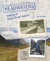
(Photo of front cover of "Headwaters: Walking to British River Sources" (2012 book).)
Howardh
Established Member
- Joined
- 17 May 2011
- Messages
- 8,155
Thanks! It would be useful if OS 1;25000 maps somehow identified the source of the major rivers, although identifying them is about as easy as working out how long a coastline is! But it would be nice to have a genuine agreed source for, say, the top 10 or 15 longest rivers, and I'm sure there are plenty of geo-nerds...sorry, enthusiasts, that would visit boosting the local tourism a little.South of Burnley at Cliviger (on the hills above Bacup) is usually acknowledged as being the source of the River Irwell, but the start of the River Mersey is normally considered to be where two of its three main tributaries meet in central Stockport, namely the Rivers Tame and Goyt, and frankly, it's not all that exciting!
If, however, you want to visit the source/location of the Mersey's longest tributary, the River Etherow, (the third of the Mersey's three main tributaries) that's up at Red Hole Spring at the top end of the Longdendale valley, and more or less directly above the course of the former Woodhead railway tunnel. It's a bit wild up there, but there can be good views to the West on a good day.
There's a 2012 book "Headwaters: Walking to British River Sources" by a Phil Clayton, which, if you've not already seen, you should still be able to easily obtain and may well find of interest.
View attachment 112921
(Photo of front cover of "Headwaters: Walking to British River Sources" (2012 book).)
THC
Member
eastwestdivide
Established Member
We did that - bit of a long walk but at least it’s downhill coming back. Canal NE from Congleton stn for a little bit, then disused railway path SE and choose a route up to Biddulph Moor. Trent Head Well was a little bit tricky to locate, and pretty overgrown in the high summer when we did it.For no good reason than I watched the train between Stafford and Crewe run alongside it, I want to ramble up to the source of the Trent, preferably when the weather's settled! It's in/on/around Biddulph Moor, Trant head Well appears to be one such location. Bit of a walk from Congleton rail though!
Iskra
Established Member
Does anyone have any good recommendations for walking boots please? My current pair that I’ve had for 18 years are slowly expiring. I don’t mind paying a decent amount for a pair if they are going to last as long as their predecessors, but don’t want to pay top whack for something that isn’t going to last.
eastwestdivide
Established Member
Take a trip to Foothills shop off Abbeydale Road in Sheffield. Good with advice and fitting. Not bargain basement, but they know what they’re doingDoes anyone have any good recommendations for walking boots please? My current pair that I’ve had for 18 years are slowly expiring. I don’t mind paying a decent amount for a pair if they are going to last as long as their predecessors, but don’t want to pay top whack for something that isn’t going to last.
I've found Altberg the most satisfactory; despite the Germanic name they are made in Yorkshire. They are available in several width fittings. Whalley Warm and Dry is a good stockist in the northwest. I think there may be a stockist in Hathersage as well, to serve S. Yorks and Derbyshire.Does anyone have any good recommendations for walking boots please? My current pair that I’ve had for 18 years are slowly expiring. I don’t mind paying a decent amount for a pair if they are going to last as long as their predecessors, but don’t want to pay top whack for something that isn’t going to last.
Iskra
Established Member
Thanks for the assistance 

Kite159
Veteran Member
Only a short walk for me today, from birchington on Sea towards Margate along the sea front path, quite busy in places with people enjoying the sunshine. Next time I will head towards Whitstable. I've heard the sea path from Margate towards Ramsgate is also meant to be nice
Although it seems I've developed a blister on the base of my foot so my planned walk of the old railway line route from Canterbury towards Whitstable tomorrow will have to be pushed back to give the blister time to heal. Might do an easy potter round Folkestone seeing as I'm in the town (the old harbour branch)
Although it seems I've developed a blister on the base of my foot so my planned walk of the old railway line route from Canterbury towards Whitstable tomorrow will have to be pushed back to give the blister time to heal. Might do an easy potter round Folkestone seeing as I'm in the town (the old harbour branch)
Have you considered using Compeed ?Although it seems I've developed a blister on the base of my foot so my planned walk of the old railway line route from Canterbury towards Whitstable tomorrow will have to be pushed back to give the blister time to heal.
ChrisC
Established Member
I walked from Birchington on Sea to Herne Bay a few years ago. That was a really enjoyable walk especially the stretch of coast around Reculver.Only a short walk for me today, from birchington on Sea towards Margate along the sea front path, quite busy in places with people enjoying the sunshine. Next time I will head towards Whitstable. I've heard the sea path from Margate towards Ramsgate is also meant to be nice
Although it seems I've developed a blister on the base of my foot so my planned walk of the old railway line route from Canterbury towards Whitstable tomorrow will have to be pushed back to give the blister time to heal. Might do an easy potter round Folkestone seeing as I'm in the town (the old harbour branch)
Kite159
Veteran Member
Have you considered using Compeed ?
That's what I've had on my foot today when I did a little loop to the Folkestone Harbour & seafront (before the crowds came).
Kite159
Veteran Member
I had a nice explore of the River Lee Country Park today, just over 14 miles starting from Enfield Lock along the canal towards Waltham before doing a "this path looks interesting" sort of walk around the various lakes & other waterways. Ended up at Cheshunt. A very relaxing place, quite beautiful in places (especially on some of the paths west of the canal).
The little fishing jetties made for good places to stand for photos, when not in use.
Yesterday, (Sunday) was a disused railway walk from Clydebank area towards Partick (Lanarkshire and Dumbartonshire Railway route) then towards Glasgow city centre via the River. Only station with platform(s) still in existence was Scotstoun East with an old signal box at one end.
I was hoping to do Balloch towards Dalmuir on Saturday (riverside walk before disused railway line then canal) but the rain put that to one side. I did manage to walk Airdrie towards Coatbridge Central along an old railway route (crossed Sheepford Viaduct) then along a disused canal in a gap in the rain.
Peter Mugridge
Veteran Member
Bedwyn railway station to Kintbury railway station along the Kennet and Avon canal; 8½ miles in 6 hours. Saturday 23rd April 2022.
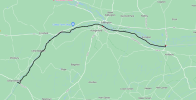
Kintbury railway station to Thatcham railway station along the Kennet and Avon canal; 10 miles in 8 hours, including a one hour stop for lunch at a canal side pub in Newbury. Saturday 30th April 2022.
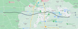

Kintbury railway station to Thatcham railway station along the Kennet and Avon canal; 10 miles in 8 hours, including a one hour stop for lunch at a canal side pub in Newbury. Saturday 30th April 2022.

Kite159
Veteran Member
I see you are slowly closing in on Reading, guess the next time will be Thatcham to the end of the canal/river at Reading?
Peter Mugridge
Veteran Member
No, two more stages: Thatcham to Theale then Theale to Reading.I see you are slowly closing in on Reading, guess the next time will be Thatcham to the end of the canal/river at Reading?
Our daily limit is around ten miles; my wife is a bit of a slow walker - I suspect I could personally probably exceed ten miles in one go; I think it's as much about the speed as it is the number of steps taken. In September 2019 we did do a 14 mile walk ( the entire Paddington Arm of the Grand Union from Hayes and Harlington to Paddington ) and that proved too much; could hardly walk for the last couple of miles and we very nearly ran out of daylight on the towpath which is a far from ideal situation...
I did an excellent walk from Settle to Clapham with the Southport Ramblers today, 9 miles in glorious weather and superb scenery (via Stainforth Force, Smearsett Scar, Feizor, Austwick and the Norber erratics). A new member also joined the club,and by coincidence he turned out to be Steve Bray of this forum.
Iskra
Established Member
That sounds excellent, it is a beautiful area, and yes, a great day for it.I did an excellent walk from Settle to Clapham with the Southport Ramblers today, 9 miles in glorious weather and superb scenery (via Stainforth Force, Smearsett Scar, Feizor, Austwick and the Norber erratics). A new member also joined the club,and by coincidence he turned out to be Steve Bray of this forum.
THC
Member
Mcr Warrior
Veteran Member
- Joined
- 8 Jan 2009
- Messages
- 11,757
Decent that. Did the slightly shorter section between West Bergholt / Great Horkesley and then Eastwards to Lawford / Manningtree Stn a few years ago and thought that was quite far enough.Chappel to Mistley, 23 miles and all but the first on the Essex Way on a glorious May day.
I did two good walks this week. On Wednesday I took a train to Hathersage and did a circular from there to Leam Farm, across Eyam Moor to Sir William Hill Road, west to the Barrel pub at Bretton, then down to Grindlow (the restricted byway that runs at a lower level than the road is closed because of subsidence in old mine workings, but the views from the road are better anyway). Then round to Great Hucklow, near the gliding club, back to the Barrel, down into Bretton Clough, through woods to Stoke Ford, then the fine footpath signed for Hazelford, emerging at a hairpin bend on the lane down to Leadmill Bridge and Hathersage. 5 hours all told, and the 1603 from Hathersage has a good connection to the 1719 for Southport at Piccadilly..
Today I was met by friends at Staveley, where the Walking Club coach dropped me, and we drove to Longsleddale parish church, parked there and then walked up the valley on the lane, then crossed over by the bridge to Wads Howe and walked down the valley to Garnett Bridge by the bridleway. At Garnett Bridge we walked up a short steep path to join a footpath from the A6, which descends to the lane. We then returned to the church car park by the lane on the other side of the valley from the bridleway, seeing only 3 cars all day. On a future walk we will park at the church again and do the upper half of Longsleddale as far as Sadgill, where the lane ends. One of the interesting features of this walk is to try to see where the railway would have gone if it had been built up Longsleddale, gone under Gatescarth Pass in a tunnel and emerged at the east side of Haweswater, as was once planned. I cannot regret that this route was never built; it would have ruined the narrow valley.
Today I was met by friends at Staveley, where the Walking Club coach dropped me, and we drove to Longsleddale parish church, parked there and then walked up the valley on the lane, then crossed over by the bridge to Wads Howe and walked down the valley to Garnett Bridge by the bridleway. At Garnett Bridge we walked up a short steep path to join a footpath from the A6, which descends to the lane. We then returned to the church car park by the lane on the other side of the valley from the bridleway, seeing only 3 cars all day. On a future walk we will park at the church again and do the upper half of Longsleddale as far as Sadgill, where the lane ends. One of the interesting features of this walk is to try to see where the railway would have gone if it had been built up Longsleddale, gone under Gatescarth Pass in a tunnel and emerged at the east side of Haweswater, as was once planned. I cannot regret that this route was never built; it would have ruined the narrow valley.
Iskra
Established Member
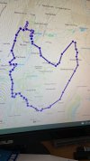
Today we did a circular walk from and around Diggle, enjoying a fine ice cream at the end at Grandpa Greens. The weather was changeable and pleasant and I had a new experience of walking along a fairly sheltered footpath just below a clay pigeon shooting area and being dashed with shotgun pellets (but we're okay). Some pleasant views were had and it was enjoyable and not too strenuous. Just a little local hike to keep me fit enough for a bigger challenge later in the year. It was around 8 miles in total with a total ascent of 450m.
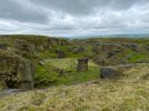
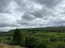
The Skyscraper of Manchester can just be seen in the distance from the top of this old quarry
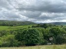
The Pots & Pans monument which we walked by can just be seen on this photo, which was taken in a nice quiet field where we had our lunch
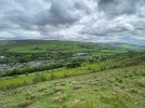
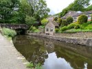
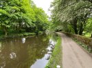
Diggle down below from the opposite side of the valley


The Skyscraper of Manchester can just be seen in the distance from the top of this old quarry


The Pots & Pans monument which we walked by can just be seen on this photo, which was taken in a nice quiet field where we had our lunch


Diggle down below from the opposite side of the valley
D6130
Established Member
Nice photos....looks like a good walk. Unfortunately, my ability to walk very far in Tuscany is currently inhibited by a bad foot and the fabulous food is playing havoc with my waistline.
Iskra
Established Member
Sorry to hear about the poorly foot! Two weeks today I will hopefully be arriving in Locri courtesy of a couple of Trenitalia loco-hauled trainsNice photos....looks like a good walk. Unfortunately, my ability to walk very far in Tuscany is currently inhibited by a bad foot and the fabulous food is playing havoc with my waistline.

High Dyke
Established Member
I completed Sections 12 & 13 of the Capital Ring last Tuesday. I actually commenced the walk at East Finchley station (in Section 11) to re-walk through Highgate Wood and Queens Wood - most idyllic. Though I'm only able to walk when work permits, and with the hour or so travel down to London this just leaves me to complete the final two sections, from Hackney Wick - Beckton District Park - Woolwich; thus completing the whole 78-mile circuit.

