-
Our booking engine at tickets.railforums.co.uk (powered by TrainSplit) helps support the running of the forum with every ticket purchase! Find out more and ask any questions/give us feedback in this thread!
You are using an out of date browser. It may not display this or other websites correctly.
You should upgrade or use an alternative browser.
You should upgrade or use an alternative browser.
What was this old railway line in Stockport, and where did it go?
- Thread starter AMR
- Start date
- Status
- Not open for further replies.
Sponsor Post - registered members do not see these adverts; click here to register, or click here to log in
R
RailUK Forums
Bletchleyite
Veteran Member
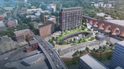
What on *earth* is that ugly monstrosity? Is that genuinely proposed?
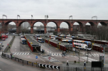
The bus station could do with a bit of a tarting-up, but that looks like it will create something a bit like the nasty underground bus stations of the 80s and not a modern steel-and-glass structure, say.
The bus station could do with a bit of a tarting-up, but that looks like it will create something a bit like the nasty underground bus stations of the 80s and not a modern steel-and-glass structure, say.
It was the Manchester South District railway. It closed in the 1960’s as part of the beeching axe.
What on *earth* is that ugly monstrosity? Is that genuinely proposed?
The bus station could do with a bit of a tarting-up, but that looks like it will create something a bit like the nasty underground bus stations of the 80s and not a modern steel-and-glass structure, say.

Bletchleyite
Veteran Member
I agree the existing one isn't pretty, but it's just a classic 1980s design. It should become something much nicer, not an underground car park with Piccadilly Gardens on top. (Stockport being Stockport, I can't see it being any more salubrious).
Yeah I agree, its not worth the investment. but the bus station is needed as that is the main transport within the area.I agree the existing one isn't pretty, but it's just a classic 1980s design. It should become something much nicer, not an underground car park with Piccadilly Gardens on top. (Stockport being Stockport, I can't see it being any more salubrious).
Sir Felix Pole
Member
The latest scheme envisages Metrolink reaching Stockport from East Didsbury via Cheadle Heath to new platforms at Edgeley station, and not along the Mersey Valley to the bus-station. This is part of wider proposals for 'tram-train' operation on the Stockport-Altrincham line via Northenden and to Hazel Grove. There is to be a pedestrian link between Edgeley station and the 'Interchange' - very unsatisfactory in my view.
Bletchleyite
Veteran Member
The latest scheme envisages Metrolink reaching Stockport from East Didsbury via Cheadle Heath to new platforms at Edgeley station, and not along the Mersey Valley to the bus-station. This is part of wider proposals for 'tram-train' operation on the Stockport-Altrincham line via Northenden and to Hazel Grove. There is to be a pedestrian link between Edgeley station and the 'Interchange' - very unsatisfactory in my view.
That's really not ideal. The main destination is the shopping centre, so Metrolink really needs to serve that (and, ideally, run up the hill to the railway station and terminate there). If it doesn't it'll just be an expensive white elephant while people continue to use the buses.
I agree there is a path between the bus station and the rail station but its really dark and gloomy and you need to climb a hill. If they paved it and made a large bridge for only pedestrians, it would make somewhat sense in which it would make the walk to the centre a lot nicer.The latest scheme envisages Metrolink reaching Stockport from East Didsbury via Cheadle Heath to new platforms at Edgeley station, and not along the Mersey Valley to the bus-station. This is part of wider proposals for 'tram-train' operation on the Stockport-Altrincham line via Northenden and to Hazel Grove. There is to be a pedestrian link between Edgeley station and the 'Interchange' - very unsatisfactory in my view.
And they should move the metrolink into the centre. and make the last stop by Redrock as there is lots of room.
I agree there is a path between the bus station and the rail station but its really dark and gloomy and you need to climb a hill. If they paved it and made a large bridge for only pedestrians, it would make somewhat sense in which it would make the walk to the centre a lot nicer.
And they should move the metrolink into the centre. and make the last stop by Redrock as there is lots of room.
Doesn't the latest design include a sloped footbridge from top level of the bus station to part of the way up the hill to allow easy disabled access between the railway and bus stations?
There was once a station called Tiviot Dale at the bottom of Lancashire Hill.It was the Manchester South District railway. It closed in the 1960’s as part of the beeching axe.
When the M63 (now M60) was built through Stockport from the west to Portwood in 1979-83, it was designed so as not to preclude the reopening of the adjacent railway tunnel, but I believe the tunnel was inadvertently damaged. The later extension of the motorway further east cuts across the former railway route to the Bredbury area.
There was once a station called Tiviot Dale at the bottom of Lancashire Hill.
When the M63 (now M60) was built through Stockport from the west to Portwood in 1979-83, it was designed so as not to preclude the reopening of the adjacent railway tunnel, but I believe the tunnel was inadvertently damaged. The later extension of the motorway further east cuts across the former railway route to the Bredbury area.
 Railway Clearing House Junction Diagrams by Mwmbwls, on Flickr
This is the RCH diagram of the former rail lines in Stockport
 central stockport tiviot dale route. by Mwmbwls, on Flickr
Street Map of Stockport
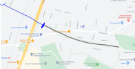
The old alignment through a cut and cover tunnel under the A6 is now irrevocably lost to the M60 - A6 link road
 The M60 to A6 link just north of Mersey Square has been completed. by Mwmbwls, on Flickr
Railway Clearing House Junction Diagrams by Mwmbwls, on Flickr
This is the RCH diagram of the former rail lines in Stockport
central stockport tiviot dale route. by Mwmbwls, on Flickr
Street Map of Stockport
The old alignment through a cut and cover tunnel under the A6 is now irrevocably lost to the M60 - A6 link road
The M60 to A6 link just north of Mersey Square has been completed. by Mwmbwls, on Flickr
The first map indicates that had the short line linking the Mid Cheshire line with Davenport not been closed in the 60s, or if it had been reopened when the Hazel Grove chord was built, then the freight line between Sharston and Hazel Grove could have been closed. It looks like houses were built on the alignment 20 or 30 years ago.
ac6000cw
Established Member
Although the passenger services on the line through Tiviot Dale station finished in the 1960s, the line was used for freight into the late 1970s at least - it was used by coal trains off the Woodhead route to reach Fiddlers Ferry power station (they changed between electric and diesel traction near Godley Junction, where the line in question joined the Woodhead route).
Damage to the tunnel in 1980 and then the closure of the Woodhead route led to it being closed and abandoned.
Damage to the tunnel in 1980 and then the closure of the Woodhead route led to it being closed and abandoned.
Last edited:
Indeed - As can be seen in this map - when Morrisons was still SafewayOne of the old railway bridges is where the exit to Morrison’s petrol station is
 A555 M60 Junction Bredbury Option 1 by Mwmbwls, on Flickr
Remains of the old track bed can be found in the nature reserve behind the Travellers Rest. Other elements of the CLC lines are now part of the Reddish Vale Country Park
 The old CLC route through Crookiley Woods by Mwmbwls, on Flickr
The spur from Woodford station serving the batching plant and waste collection centre finishes behind the DIY centre next to Morrisons
 Metrolink Tram Train - Woodley to Hyde by Mwmbwls, on Flickr
Some elements of these routes could perhaps be reclaimed for Metrolink - if urban planners wake up to the possibilities
Fantastic photos. I think originally the line went upto 4 tracks after romiley junction and the left 2 went off to tiviot dale, joining the spur from Woodley.
It’s a shame the rail link was lost to Stockport as I imagine there would’ve been potential for a lot of commuter traffic.
It’s a shame the rail link was lost to Stockport as I imagine there would’ve been potential for a lot of commuter traffic.
bramling
Veteran Member
The eastern end of the tunnel running parallel to the motorway in Stockport is visible, a road bridges the portal near where Tiviot dale station was, the eastern end seems to be filled in.
There were originally three tunnels. The easternmost of the three (Tiviot Dale) still exists, and would seem to be the one which was damaged.
The westernmost tunnel (Wellington Road) was largely obliterated a couple of years ago as part of construction of a relief road, only the east portal survives.
The middle tunnel (Brownsword) was more of a bridge than a tunnel, and seems to have vanished many years ago, possibly even before the line closed.
Indeed - As can be seen in this map - when Morrisons was still Safeway
A555 M60 Junction Bredbury Option 1 by Mwmbwls, on Flickr
Remains of the old track bed can be found in the nature reserve behind the Travellers Rest. Other elements of the CLC lines are now part of the Reddish Vale Country Park
The old CLC route through Crookiley Woods by Mwmbwls, on Flickr
The spur from Woodford station serving the batching plant and waste collection centre finishes behind the DIY centre next to Morrisons
Metrolink Tram Train - Woodley to Hyde by Mwmbwls, on Flickr
Some elements of these routes could perhaps be reclaimed for Metrolink - if urban planners wake up to the possibilities
There have been investigations into reusing bits of the route but it is unlikely to be chosen over using the freight line through Reddish South. If Piccadilly to Rose Hill becomes a tram train route then a chord could easily link the two lines and get services to near the A6 without sharing track with heavy rail passenger services. It would be tricky from there to Stockport bus station and or railway station but the same is true of a line from the east.
martin2345uk
Established Member
There's still a platform remaining at Tiviot Dale, at least there was a couple of years ago when I was last there.
- Status
- Not open for further replies.


