• Our booking engine at tickets.railforums.co.uk (powered by TrainSplit) helps support the running of the forum with every ticket purchase! Find out more and ask any questions/give us feedback in this thread!

Storm Ciarán: Weather related disruption 1/2 November

Status
Not open for further replies.

bramling

Veteran Member
Joined
5 Mar 2012
Messages
17,882
Location
Hertfordshire / Teesdale
Surprised this hasn’t cropped up here yet, however there looks to be a rather vicious storm arriving Wednesday night into Thursday morning.

The exact track isn’t certain, but it looks to have the potential to bring some serious disruption to southern counties especially along the coast as a result of strong wind gusts, especially with ground being saturated and trees in full leaf still.

If it swings northwards then it could bring London into play, though this isn’t clear at the moment.
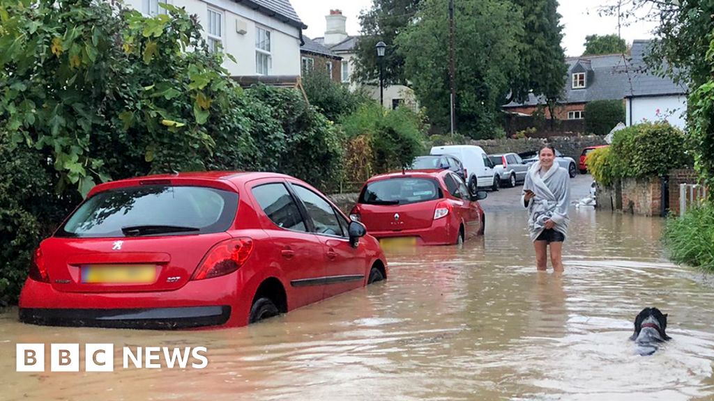
Ciarán is set to bring strong winds and heavy rain to southern England and Wales when it arrives on Thursday.

"Stormy conditions are initially likely across southern England and the Channel Isles early on Thursday with damaging gusts of wind up to 80mph, perhaps even 90mph in the most exposed areas. Heavy rain will then spread north and east through the day."
 
Last edited by a moderator:
Sponsor Post - registered members do not see these adverts; click here to register, or click here to log in
R

RailUK Forums

dk1

Veteran Member
Joined
2 Oct 2009
Messages
16,254
Location
East Anglia
Surprised this hasn’t cropped up here yet, however there looks to be a rather vicious storm arriving Wednesday night into Thursday morning. The exact track isn’t certain, but it looks to have the potential to bring some serious disruption to southern counties especially along the coast as a result of strong wind gusts, especially with ground being saturated and trees in full leaf still. If it swings northwards then it could bring London into play, though this isn’t clear at the moment.

Glad I’m on a day shift Thursday. Fed up with getting stuck/delayed lately with flooding etc.
 

Wivenswold

Established Member
Joined
24 Jul 2012
Messages
1,478
Location
Essex
After some shifts south in the model output last night there was hope that this wouldn't be more than a very wet, windy autumnal day. However, today it looks like it will be very bad for the SW, South and South East, possibly also quite bad across East Anglia for a time too. In fact the similarities between this system and Oct 87 are striking and like that famous storm, we've had weeks of rain and trees are still in nearly full leaf.

I think we can expect announcements about a reduced service from all of the TOCs with services that go within 30 miles of the coast from Transport for Wales in the West to Greater Anglia in the East.
 

bramling

Veteran Member
Joined
5 Mar 2012
Messages
17,882
Location
Hertfordshire / Teesdale
After some shifts south in the model output last night there was hope that this wouldn't be more than a very wet, windy autumnal day. However, today it looks like it will be very bad for the SW, South and South East, possibly also quite bad across East Anglia for a time too. In fact the similarities between this system and Oct 87 are striking and like that famous storm, we've had weeks of rain and trees are still in nearly full leaf.

I think we can expect announcements about a reduced service from all of the TOCs with services that go within 30 miles of the coast from Transport for Wales in the West to Greater Anglia in the East.

I guess the big question is … how far north is this going to affect? It seems that isn’t fully clear yet.
 

dk1

Veteran Member
Joined
2 Oct 2009
Messages
16,254
Location
East Anglia
After some shifts south in the model output last night there was hope that this wouldn't be more than a very wet, windy autumnal day. However, today it looks like it will be very bad for the SW, South and South East, possibly also quite bad across East Anglia for a time too. In fact the similarities between this system and Oct 87 are striking and like that famous storm, we've had weeks of rain and trees are still in nearly full leaf.

I think we can expect announcements about a reduced service from all of the TOCs with services that go within 30 miles of the coast from Transport for Wales in the West to Greater Anglia in the East.

Crikey. Remember the 87 storm well. Hadn’t been working on the railway long then.
 

TrainGeekUK

Member
Joined
15 Jun 2019
Messages
124
It’s certainly not looking good weather wise…. its still teaming it down now in Eastbourne, heaven knows what it’ll be like on Thursday!
 

MikeWM

Established Member
Joined
26 Mar 2010
Messages
4,445
Location
Ely
Yeah, this looks pretty bad, and (currently) worse the further south you go, though the precise track is still moving around a bit. The charts are currently showing a very clear hurricane-style 'eye' in the middle of the storm too, with unusual clarity for this part of the world.

I wouldn't plan on doing much on Thursday in the south of England unless totally unavoidable. I don't think much on the railways will be getting started, and what does will fall over pretty swiftly.
 

Techniquest

Veteran Member
Joined
19 Jun 2005
Messages
21,674
Location
Nowhere Heath
Is this a named storm then? I haven't been keeping an eye on the weather forecast since Friday, as I've been indoors for almost 3 solid days, so the news of potential major disruption has caught me off-guard.

Luckily for me I'm not due to go anywhere this week, but I'm certainly intrigued by yet more severe weather. Especially if it's due to land anywhere near here, it's been pretty dry the last couple of days here overall but that means nothing!
 

bramling

Veteran Member
Joined
5 Mar 2012
Messages
17,882
Location
Hertfordshire / Teesdale
Thanks :) With every week that passes, that seems to bring more intense weather, it seems to be a sign that re-evaluating one's love of the outdoors needs to happen!

Don’t go there on that one! As someone who does predominantly outdoor stuff, this whole year has been absolutely dire, especially the so-called summer. This storm could be a different ball-game though for people in the affected areas.
 

rg177

Established Member
Associate Staff
International Transport
Joined
22 Dec 2013
Messages
3,751
Location
Newcastle-upon-Tyne
I'm doing Sheffield - London - Heathrow on Thursday (long-haul international flight on Friday) so hoping I can get down there relatively unscathed. Looks like the worst will be towards the coasts.
 

Techniquest

Veteran Member
Joined
19 Jun 2005
Messages
21,674
Location
Nowhere Heath
Don’t go there on that one! As someone who does predominantly outdoor stuff, this whole year has been absolutely dire, especially the so-called summer. This storm could be a different ball-game though for people in the affected areas.

Yes I noted on a completely different thread your mentioning of being a fitness enthusiast. I was pleased to read another forum member is heavily into their fitness, and it pleases me to hear of someone else who is not pleased with this year's weather! I'll leave that discussion where it is in this thread, but I may drop a PM your way in a bit :)

As for the weather disruption, here's hoping it won't be anything too severe for any of us on the forum :) Unsurprisingly, even if I'm back to being well again by then, I'm not planning any major adventures this week!
 

philosopher

Established Member
Joined
23 Sep 2015
Messages
1,360
Yeah, this looks pretty bad, and (currently) worse the further south you go, though the precise track is still moving around a bit. The charts are currently showing a very clear hurricane-style 'eye' in the middle of the storm too, with unusual clarity for this part of the world.

I wouldn't plan on doing much on Thursday in the south of England unless totally unavoidable. I don't think much on the railways will be getting started, and what does will fall over pretty swiftly.
My guess is that there will be no services south of London before either 9am or midday on Thursday.
 

bramling

Veteran Member
Joined
5 Mar 2012
Messages
17,882
Location
Hertfordshire / Teesdale
Yes I noted on a completely different thread your mentioning of being a fitness enthusiast. I was pleased to read another forum member is heavily into their fitness, and it pleases me to hear of someone else who is not pleased with this year's weather! I'll leave that discussion where it is in this thread, but I may drop a PM your way in a bit :)

Yes please feel free.

As for the weather disruption, here's hoping it won't be anything too severe for any of us on the forum :) Unsurprisingly, even if I'm back to being well again by then, I'm not planning any major adventures this week!

At this stage it’s a case of keeping everything crossed that this storm stays as far south as possible and therefore affects as few people as possible. I wrote off doing anything outdoors long ago with the way this year has been! :)
 

Nicholas Lewis

Established Member
Joined
9 Aug 2019
Messages
6,238
Location
Surrey
My guess is that there will be no services south of London before either 9am or midday on Thursday.
GTR have us on notice that speeds restrictions will be in force and some routes may have to be closed but unlike ScotRail keeping the door open until things become clearer.
 

SCDR_WMR

Established Member
Joined
17 Dec 2017
Messages
1,605
Rather a large amount of rain falling across the North Midlands this afternoon, hopefully and more severe weather misses here!
 

londonmidland

Established Member
Joined
22 Dec 2009
Messages
1,866
Location
Leicester
Over the last 24 hours the models have been shifting the low pressure system slowly northwards, which long story short means more disruption for more of the country.

Still a long way to go in terms of forecasting between now and then, however should there be any further shifts towards the north, the nastier things will get for many.
 

trainophile

Established Member
Joined
28 Oct 2010
Messages
6,300
Location
Wherever I lay my hat
I wonder will it last into next week, and affect the North East? Got my final trip of the year to glorious Whitley Bay (waves @Willie Bee) of the year. Just when it's safe not to cancel re. train strikes, the weather goes and throws its oar in :rolleyes: .
 

rg177

Established Member
Associate Staff
International Transport
Joined
22 Dec 2013
Messages
3,751
Location
Newcastle-upon-Tyne
I wonder will it last into next week, and affect the North East? Got my final trip of the year to glorious Whitley Bay (waves @Willie Bee) of the year. Just when it's safe not to cancel re. train strikes, the weather goes and throws its oar in :rolleyes: .
Just down the road from Whitley Bay here and we haven't had anything like severe flooding but we've still had some truly miserable weather.

I think just about every day in the past week it's rained. We had a brief respite on Saturday but other than that...
 

Mcr Warrior

Veteran Member
Joined
8 Jan 2009
Messages
12,345
Over the last 24 hours the models have been shifting the low pressure system slowly northwards, which long story short means more disruption for more of the country.

Still a long way to go in terms of forecasting between now and then, however should there be any further shifts towards the north, the nastier things will get for many.
Latest BBC weather forecast seems to be indicating rather high (70 mph + winds) all the way along the South Coast on late Wednesday/early Thursday, from Wales over to the Thames Estuary. That's a lot of coastline!
 

Busaholic

Veteran Member
Joined
7 Jun 2014
Messages
14,229
Latest BBC weather forecast seems to be indicating rather high (70 mph + winds) all the way along the South Coast on late Wednesday/early Thursday, from Wales over to the Thames Estuary. That's a lot of coastline!
If Wales becomes the South Coast, then I'm a gonner in Penzance. :smile: Know what you mean though. Not too worried my car's clutch has just gone, wouldn't be driving anywhere antway.
 

Sun Chariot

Established Member
Joined
16 Mar 2009
Messages
1,557
Location
2 miles and 50 years away from the Longmoor Milita
The Sunny South Coast - Hampshire / West Sussex border - has been anything but, for the 7 years I've lived here.
Our local roads are only just drying out from the pummelling last week and the weekend.
 

Attachments

  • Bedhampton_Stockheath_flood.jpg
    Bedhampton_Stockheath_flood.jpg
    5.3 MB · Views: 57

Russel

Established Member
Joined
30 Jun 2022
Messages
1,277
Location
Lichfield
Looks like North Wales now also has a yellow warning for wind and rain on Thursday...

Great, I'd booked some rather cheap advances to take my son to Llandudno for an hour or so on the pier then have a run down the Conwy Valley Line to Betws-Y-Coed, but I'm guessing that'll be washed away by lunch time!
 

Blindtraveler

Established Member
Joined
28 Feb 2011
Messages
9,780
Location
Nowhere near enough to a Pacer :(
I'm obviously out of practice, used to be far more organized and far less anxious about these named storms but despite only being eight months since I moved that's eight months without being on some kind of mad weather alert and now feeling slightly concerned about it all, hoping that it doesn't pick up until bedtime tonight so I can get to London and do what's needed and get back without being blown away, unlikely if anyone has seen how much I weigh these days or swamped
 

Horizon22

Established Member
Associate Staff
Jobs & Careers
Joined
8 Sep 2019
Messages
7,737
Location
London
Southern are now suggesting people work from home. Suggestions are the air pressure will be some of the lowest in decades.

Storm Ciarán: England and Channel Islands prepare for disruption https://www.bbc.co.uk/news/uk-england-67271027

Gusts of up to 80mph could cause travel disruption, damage to buildings and flying debris.
There are also flood warnings in place.

Storm Ciarán conditions on the Channel Islands are predicted to be the worst in more than 36 years. Main coastal roads on Jersey will be closed later and schools and the airport shut down on Thursday

People in Jersey and Guernsey have also been asked not to stockpile goods after supermarket shelves were stripped

Two hundred one-tonne bags of sand have been put at the top of slipways along the south coast of Jersey

Alerts for the Essex coast have been upgraded to amber from 06:00 GMT to 20:00 on Thursday

Southern Railway has urged commuters to work from home, warning it would be unlikely to provide rail replacement transport
 

DelW

Established Member
Joined
15 Jan 2015
Messages
3,979
Southern are now suggesting people work from home. Suggestions are the air pressure will be some of the lowest in decades.

Storm Ciarán: England and Channel Islands prepare for disruption https://www.bbc.co.uk/news/uk-england-67271027
The low atmospheric pressure has implications for coastal locations and routes, as lower pressure = higher sea level. Dawlish's defences could be tested again, among others.
 

AndrewE

Established Member
Joined
9 Nov 2015
Messages
5,176
The low atmospheric pressure has implications for coastal locations and routes, as lower pressure = higher sea level. Dawlish's defences could be tested again, among others.
It should be fun there this evening: Screenshot 2023-11-01 at 12-05-14 Dawlish - BBC Weather.png(High tide at 2043, plus heavy rain and 57 mph wind S.Easterly...)
 

PTR 444

Established Member
Joined
22 Aug 2019
Messages
2,289
Location
Wimborne
I have plans to travel from Poole to Sutton (London) this Friday evening, returning on Sunday. I already have train tickets booked but is it worth booking coach travel as a backup option?
 

Horizon22

Established Member
Associate Staff
Jobs & Careers
Joined
8 Sep 2019
Messages
7,737
Location
London
I have plans to travel from Poole to Sutton (London) this Friday evening, returning on Sunday. Do you think it is worth abandoning my plans or booking coach travel as a backup option?

Should be clearer by Friday evening. Current advice is just to check your travel / route regularly.
 
Status
Not open for further replies.

Top