• Our new ticketing site is now live! Using either this or the original site (both powered by TrainSplit) helps support the running of the forum with every ticket purchase! Find out more and ask any questions/give us feedback in this thread!

Cities: Skylines - Designing a transit-friendly city without congestion

Status
Not open for further replies.

PTR 444

Established Member
Joined
22 Aug 2019
Messages
2,411
Location
Wimborne
One of my favourite games of all time is Cities: Skylines, which is no surprise considering my love for designing fictional civilisations. I have created at least a dozen different cities but one of the biggest issues plaguing all of these is they have all become gridlocked as the game has progressed. While the program does remove traffic if there has been a bottleneck for a while, this scenario obviously cannot happen in real life. I'd be interested to hear from some industry experts on how you would go about designing a congestion free transit-friendly city using this game, either from scratch or editing an already existing map.

Considering the need to have roads for emergency service and city service vehicles (waste collection etc), a 100% traffic free scenario is unlikely to be realistic, however my aim would be to get to as little car ownership as possible by enhancing the transit options available at the most efficient cost. I have the Mass Transit expansion pack which gives me access to Buses, Metro, Train, Ferry and Cable Car, so have plenty of options available. The point is that I would try and avoid using modes which are in excess of what is required for demand, so for example using Metro (above ground) for local lines rather than Train. Using buses for these flows would be inefficient as they would only create even more congestion for the demand that is required.

I would also try and design demand around the major hubs, so for example only zoning high density outside major transportation hubs, and industrial near to freight rail terminals and seaports. It always gobsmacks me at the start of the game when you zone industrial since the local roads always get clogged up with trucks. Maybe I just zone buildings too close together, but then if you place them further apart you end up spending far more on power lines.

Another question is what sort of map I should use for my "transport utopia" metropolis. Many of the default in-game maps are pretty generic with not many mountains or water features, but choosing such a map would give me more of a challenge to work towards and make the game more interesting (a city with boats or cable cars as its fastest mode of travel hey). Alternatively, I could build my city based on a Runcorn style model with busways and low density dwellings, or a Milton Keynes style one starting with a series of small settlements before joining them together with high density development later on in the game.

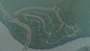
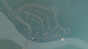
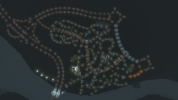
If I can find them, I will attach some screenshots of a previous transit-friendly development I attempted to create. I focused everything on one central railway station with a connecting bus network converging on it, but the amount of buses has led to the densely-packed central area becoming very congested. I always seem to have this problem with buses converging in the same place within a city centre, hence my idea to solely use Metro or Train for these flows and leave buses for the lower density flows.
 
Sponsor Post - registered members do not see these adverts; click here to register, or click here to log in
R

RailUK Forums

zwk500

Veteran Member
Joined
20 Jan 2020
Messages
15,033
Location
Bristol
With buses I find the game's default logic for lane allocation to be very poor, and even poorer on Bus Lanes, so I count Traffic Manager as an essential mod (Paradox have a history of letting modders create the features they really should have included).
Other than that, the key is to cluster high density around transit stations and then lower density out, also mix up residential and commercial - don't go for the overly-american zoning practices, this helps reduce the amount of people looking to cross from one side of the city to the other. Also don't underestimate Walking and Cycling - you can really get a grip on congestion problems with a really good cycleway network - which mirrors the 'New Towns' movement in real life.
It's also useful to check where flows are actually going in-game often, as the game logic does interesting things that aren't always intuitive pathing from a real-world perspective. I have a bad habit of overlooking bus networks, although my metro networks tend to be reasonably well used, although I have a playstyle that perhaps best expressed as 'definitely a game, but could have a real-world counterpart', whereas most youtubers tend to be either hyper-detailed realism or min/max optimisation of mechanics.
 

PTR 444

Established Member
Joined
22 Aug 2019
Messages
2,411
Location
Wimborne
With buses I find the game's default logic for lane allocation to be very poor, and even poorer on Bus Lanes, so I count Traffic Manager as an essential mod (Paradox have a history of letting modders create the features they really should have included).
Other than that, the key is to cluster high density around transit stations and then lower density out, also mix up residential and commercial -
While the actual variety of roads available is superb (the most recent update includes bus-only highways and 4-lane roads the same width as a 2-lane one), I agree that traffic doesn't always use the space efficiently, particularly with 6-lane roads. This is why I am tempted to build future cities in a Runcorn-style model with one main arterial road and each residential/commercial area connected with its own GSJ. The addition of bus-only highways is a blessing as these can be used to shorten the distance between suburbs for public transport, without the risk of private vehicles using them too.
don't go for the overly-american zoning practices, this helps reduce the amount of people looking to cross from one side of the city to the other. Also don't underestimate Walking and Cycling - you can really get a grip on congestion problems with a really good cycleway network - which mirrors the 'New Towns' movement in real life.
One thing I have a really bad habit of overlooking. I always seem to paint each block (usually 8x16 squares) either green (residential) or blue (commercial) as that saves time, but having more mixed European-style zoning could be a game changer in making my city very walkable. If only there were a policy that encourages residents to prefer working within the same district as where they live!
It's also useful to check where flows are actually going in-game often, as the game logic does interesting things that aren't always intuitive pathing from a real-world perspective. I have a bad habit of overlooking bus networks, although my metro networks tend to be reasonably well used, although I have a playstyle that perhaps best expressed as 'definitely a game, but could have a real-world counterpart', whereas most youtubers tend to be either hyper-detailed realism or min/max optimisation of mechanics.
Again, something I tend to overlook quite a bit. It is more difficult to judge exact traffic demand with a grid-like system as one could use multiple roads to get between the same places. At least the Runcorn model should favour public transport use over driving, simplifying the number of transportation corridors people use.
 

zwk500

Veteran Member
Joined
20 Jan 2020
Messages
15,033
Location
Bristol
One thing I have a really bad habit of overlooking. I always seem to paint each block (usually 8x16 squares) either green (residential) or blue (commercial) as that saves time, but having more mixed European-style zoning could be a game changer in making my city very walkable. If only there were a policy that encourages residents to prefer working within the same district as where they live!
On this point, one of the best visual tips I got from a youtuber is to play around with controlling plot sizes - you can still have an 8x16 block, but if you zone it first in a zigzag pattern with a mix of 2x4, 3x4, and 4x4 buildings you get a much nicer feel to your residential areas. You can also go to the other extreme, and zone only 1 size of plot, e.g. 2x4, and then watching to ensure you only get a specific growable, demolishing anything that spawns you don't want.
RTGamer recommended above is an excellent channel, I also look at Biffa, Imperatur and Yumble every so often. Biffa does a 'fix my city traffic series' where he takes viewer's cities and tries to get the traffic up.
 

PTR 444

Established Member
Joined
22 Aug 2019
Messages
2,411
Location
Wimborne
So I have finally decided to have a crack at building a transit-oriented megalopolis. I have named it New Runcorn as a homage to the UK new town of the same name, and similarly will also be built with an orbital expressway encircling the suburbs.

This first district of mine, which I will be naming Murdishaw Hill, is a low density residential and commercial neighbourhood built around the bank of the river. A single access road connects it with the expressway, which itself has multiple access points to the in-game highway network. The district itself is served by a looping S2 arterial road, complete with cycle lanes and residential roads leading off it. The first stage of the city’s busway/cycleway has been built inside the loop, which will eventually connect with other outlying suburbs. For travel into the city centre (which will eventually be built in the middle of the map), a metro station with passive provision for a new line has been sited near the top of the district.

I have also built the city’s first industrial district, solely farmland, some distance north with its own dedicated highway connection. This is to separate car and truck flows, although I intend to extend the busway network to this district at some point later in the game.

Any feedback and suggestions for planning future districts on this map would be greatly appreciated.
 

Attachments

  • 725CC099-2F7D-434B-BE1E-8CDB806628AE.png
    725CC099-2F7D-434B-BE1E-8CDB806628AE.png
    2.6 MB · Views: 35
  • 6841EFDB-46C8-4C72-8529-2068B09FC85A.png
    6841EFDB-46C8-4C72-8529-2068B09FC85A.png
    2.9 MB · Views: 34
  • 5134FFF8-1ED2-4F10-B173-553A7553B7EB.png
    5134FFF8-1ED2-4F10-B173-553A7553B7EB.png
    2.5 MB · Views: 31
  • C80E5488-511B-412C-B080-571F9FBA8024.png
    C80E5488-511B-412C-B080-571F9FBA8024.png
    2.6 MB · Views: 30
  • A9F803DB-7672-4F76-9A1D-39B291B5B402.png
    A9F803DB-7672-4F76-9A1D-39B291B5B402.png
    2.1 MB · Views: 32
  • 1C378727-AAFA-4541-AE5B-5EBFEA616FEB.png
    1C378727-AAFA-4541-AE5B-5EBFEA616FEB.png
    3.2 MB · Views: 36
Status
Not open for further replies.

Top