Buzby
Member
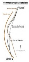
For the first time in ages, I’m hurtling down to London KX from Waverley during daylight hours - at the section at Grantshouse the railway takes a (short) realgnment due to the collapse of a tunnel during structural maintenance many years ago. Looking at the topography, and how well the later diversion fitted in to the landscape, I couldn’t fathom why the promoters felt the need to construct an expensive tunnel at this location in the first place when it was so easily avoided subsequently.
Has anyone got an insight into this as it seems odd at first glance!
Has anyone got an insight into this as it seems odd at first glance!