• Our new ticketing site is now live! Using either this or the original site (both powered by TrainSplit) helps support the running of the forum with every ticket purchase! Find out more and ask any questions/give us feedback in this thread!

HS1: is there a published gradient profile?

Status
Not open for further replies.

S&CLER

Member
Joined
11 Jan 2020
Messages
787
Location
southport
Yesterday I picked up a copy of Ken Cordner's 2008 book Tunnel Vision, about the construction of HS1. It is an interesting read with excellent photographs, but surprisingly no gradient profile. I haven't seen one in any other publication on the Tunnel/CTRL either. Can anyone point me to a published gradient profile? Cordner says tantallsingly that only 2.8 miles of the whole route from St Pancras to the tunnel are level.

It may also interest those in the area that I bought the book from the very cheap Samaritans bookshop in Colne market and noticed that they are having a railway books and mags event on 21-22 January.
 
Sponsor Post - registered members do not see these adverts; click here to register, or click here to log in
R

RailUK Forums

civ-eng-jim

Member
Joined
16 Jul 2011
Messages
399
Location
UK
Here you go:

I had a quick skim through and could only see 2.46miles of level track.
 

Attachments

  • HS1 Schematic Layout Alignment_78862026.pdf
    1.1 MB · Views: 230
Last edited:

S&CLER

Member
Joined
11 Jan 2020
Messages
787
Location
southport
Here you go:

I had a quick skim through and could only see 2.46miles of level track.
Many thanks. I thought the Chatham line was quite a saw-tooth, and one of the most difficult of the main lines from London, but HS1 beats it; of course its curvature is incomparably better than the LC&D.
 

notadriver

Established Member
Joined
1 Oct 2010
Messages
3,704
You can see some lengthy 1 in 40 gradients going into the Thames Tunnel only slightly less than the 1 in 37 of the Lickey.
 

Legolash2o

Member
Joined
27 Sep 2018
Messages
673
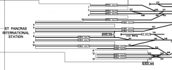
Where exactly does 0km start? The end of the platform at St Pancras or at the tunnels near York Way Jn?
 

civ-eng-jim

Member
Joined
16 Jul 2011
Messages
399
Location
UK
Judging by the 0.442km marker on the end of the international platforms, I'd imagine it was the buffers on Platforms 5-10

1642346365210.png
 

Legolash2o

Member
Joined
27 Sep 2018
Messages
673
Judging by the 0.442km marker on the end of the international platforms, I'd imagine it was the buffers on Platforms 5-10

View attachment 108864
Thanks

== Doublepost prevention - post automatically merged: ==

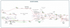
Is there a similar diagram for beyond Dollands Moor Yard please? Hopefully it'll show the channel tunnel itself.
 
Last edited:

rob365

Member
Joined
12 Feb 2019
Messages
13
Judging by the 0.442km marker on the end of the international platforms, I'd imagine it was the buffers on Platforms 5-10

View attachment 108864
Correct, 0.000km is the buffer stops for P5-10. P11-13 start at 0.228km

== Doublepost prevention - post automatically merged: ==

Thanks

== Doublepost prevention - post automatically merged: ==

Is there a similar diagram for beyond Dollands Moor Yard please? Hopefully it'll show the channel tunnel itself.
1642776815535.png
Layout diagram here, but can't find topography.
 
Last edited:

LNW-GW Joint

Veteran Member
Joined
22 Feb 2011
Messages
21,151
Location
Mold, Clwyd
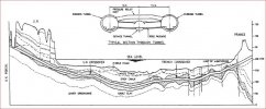
This diagram gives an idea of the vertical alignment of the tunnel: from Channel Tunnel: Construction of the World's Longest Underwater Tunnel - The Constructor

1642779748769.jpeg

I thought a 2% gradient (1 in 50) was part of the design for the land tunnels to reach the main undersea section, and this therefore determined the specification for the traction used on tunnel services, with the need for one loco to haul a complete train (shuttle/freight) out of the tunnel.
 
Status
Not open for further replies.

Top