• Our new ticketing site is now live! Using either this or the original site (both powered by TrainSplit) helps support the running of the forum with every ticket purchase! Find out more and ask any questions/give us feedback in this thread!

Kirkdale station - did it ever have four platforms?

Status
Not open for further replies.

Springs Branch

Established Member
Joined
7 Nov 2013
Messages
1,582
Location
Where my keyboard has no £ key
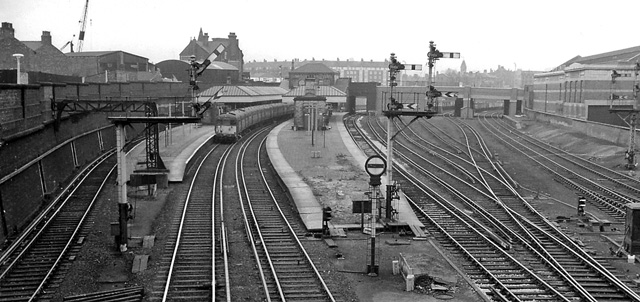
Did Kirkdale ever have four platforms?

Until the 1960s, there were four main running lines between Liverpool Exchange and Walton Junction, and passing through Kirkdale station. The fast lines were the eastern pair (continuing towards Wigan), while slow lines were on the western side (continuing towards Ormskirk and still in use by Merseyrail).

Disused tunnels for the former fast lines can still be seen between Kirkdale and Walton (the right-hand tunnels in modern images below).

A Google image search throws up a few historic photos of Kirkdale station in DMU days, but there were only two platforms by the time these were taken. It's unclear whether any platforms on the fast line side had been demolished, or they had never been built.

Kirkdale_railway_station_-_geograph.org.uk_-_1162361.jpg

Copyright Raymond Knapman at geograph.org.uk. Licensed for reuse under Creative Commons Attribution-ShareAlike 2.0

640px-Kirkdale_to_Rice_Lane_Railway_Tunnel_%28geograph_2995961%29.jpg

Copyright El Pollock at geograph.org.uk. Licensed for reuse under Creative Commons Attribution-ShareAlike 2.0
 
Sponsor Post - registered members do not see these adverts; click here to register, or click here to log in
R

RailUK Forums

Bletchleyite

Veteran Member
Joined
20 Oct 2014
Messages
104,132
Location
"Marston Vale mafia"
Yes, it did - there is an image, no text so I can't quote, from 1936 in "Britain from above" which clearly shows four platform faces:

https://britainfromabove.org.uk/en/image/EPW051321

That's changed significantly - I guess the present EMU depot must have been built on the site of cleared housing?

While it is 4 platforms, it appears to me that what you actually have there is the present two platforms as islands, i.e. there would still have been no platform on the Liverpool bound fast line, the extra ones would have been on the Preston bound slow line and the present depot line?

Interesting that the bridge appears to have had arches added later, presumably for strengthening, you can sort of see where that was done.
 

Peter Mugridge

Veteran Member
Joined
8 Apr 2010
Messages
16,150
Location
Epsom
I presume so about the depot. Unfortunately there's not a lot of other pictures of the area on that site and most appear to have been taken on the same mission. Just go to their home page an search "Kirkdale" and you'll find them.
 

Springs Branch

Established Member
Joined
7 Nov 2013
Messages
1,582
Location
Where my keyboard has no £ key
The aerial picture in the link in Post #2 is Bank Hall station on the Southport line, not Kirkdale on the Ormskirk/Wigan lines.
Bank Hall definitely did have four platforms in the past, here's a photo of Bank Hall from the 1960s - taken presumably from that bridge in the upper left of the aerial picture.

1752551_bae1269b.jpg

Bank Hall station. Copyright Ben Brooksbank at geograph.org.uk. Licensed for reuse under Creative Commons Attribution-ShareAlike 2.0

Unfortunately, historic photos of Kirkdale station seem to be few and far between.
 

Bletchleyite

Veteran Member
Joined
20 Oct 2014
Messages
104,132
Location
"Marston Vale mafia"
The aerial picture in the link in Post #2 is Bank Hall station on the Southport line, not Kirkdale on the Ormskirk/Wigan lines.

Ah...I was jumping to conclusions about the bridge then! It does however look like the deck of the Kirkdale bridges is not of the same vintage as the arches!

If it was 3 faces then the third one was probably the current depot line, not the fasts? That does look like, at the north end, it used to have another face.
 

L+Y

Member
Joined
4 Jul 2011
Messages
472
As per the previous poster, the aerial shot is Bank Hall station, not Kirkdale.

I don't think Kirkdale ever had platforms on the Fast lines, especially given the track layout at Kirkdale East junction easily allowed stopping trains from the Kirkby direction to cross over to the slows just before the station.
 

krus_aragon

Established Member
Joined
10 Jun 2009
Messages
6,100
Location
North Wales
A look at the 1893, 1908, and 1927 OS 25-inch maps suggest that the station didn't have four platforms. It may have had a third platform, on the opposite side of the northern-most island platform, but there's clearly an embankment or incline (rather than a platform face) on the southern side of the other island platform, and on the far side of the tracks.
 

mwmbwls

Member
Joined
14 Dec 2009
Messages
676
As per the previous poster, the aerial shot is Bank Hall station, not Kirkdale.

I don't think Kirkdale ever had platforms on the Fast lines, especially given the track layout at Kirkdale East junction easily allowed stopping trains from the Kirkby direction to cross over to the slows just before the station.

You are correct.
Jim Markland's 2008 book "Footplate Memories Bolton Trinity Street to Liverpool Exchange" Foxline Publicatons Scenes from the Past 54, ISBN 978 1 870119 90 0, page 111 has a 1967/8 picture of Kirkdale. The track sequence from north west to south east was up goods,down goods,(up slow platform) up slow down slow (down slow platform) up fast down fast. The stations buildings on the down slow platform offered a blank rear wall face to the fast lines. The author notes that the station design indicated that fast line platforms may have been considered at one time as an option that was never taken up.
 

S&CLER

Member
Joined
11 Jan 2020
Messages
787
Location
southport
John Marshall's Lancashire and Yorkshire Railway, vol. 2 pp. 98-99, explains how the Kirkdale area was widened in 1901-04. New tunnels were made to the west of the old formation and became the slow lines. The old tunnels became the fast lines and never had platforms at Kirkdale. The spoil from the tunnel widening was tipped alongside the railway between Aintree and Maghull, and the widened embankment, which never carried tracks, can still be seen just north of Switch Island and the M58 from the down side of an Ormskirk train. Don't confuse this with the still visible remnants of the other embankment of the former Southport and Cheshire Lines Extension, which ran parallel with the L&Y from Aintree to Old Roan and then curved northwest. As a child I used to be puzzled why there were no CLC platforms at Old Roan, where the lines were parallel and on the same level only yards apart.
 

Bevan Price

Established Member
Joined
22 Apr 2010
Messages
7,819
I presume so about the depot. Unfortunately there's not a lot of other pictures of the area on that site and most appear to have been taken on the same mission. Just go to their home page an search "Kirkdale" and you'll find them.
Kirkdale depot is built on the site of Bank Hall (27A) steam depot / depot yard.
 

Taunton

Established Member
Joined
1 Aug 2013
Messages
11,128
I don't think Kirkdale ever had platforms on the Fast lines, especially given the track layout at Kirkdale East junction easily allowed stopping trains from the Kirkby direction to cross over to the slows just before the station.
Looking at a 1939 LMS timetable, the northbound stopping trains on the Kirkby line stop at Kirkdale, except in the evening peak when they serve everywhere except there, presumably staying on the fast lines throughout when there were intensive intervals on the Ormskirk electrics.
 

randyrippley

Established Member
Joined
21 Feb 2016
Messages
5,383
Kirkdale_railway_station_-_geograph.org.uk_-_1162361.jpg

Copyright Raymond Knapman at geograph.org.uk. Licensed for reuse under Creative Commons Attribution-ShareAlike 2.0


I don't think I've ever seen a bridge like this, incorporating the gable end of a building.
Was it a house or an early railway building? The original arch on the left lines up with it, but the newer arch on the right cuts into it. Is that when it was taken down?
Interesting that the arch in use is the older one, it looks smaller
 

Bletchleyite

Veteran Member
Joined
20 Oct 2014
Messages
104,132
Location
"Marston Vale mafia"
I don't think I've ever seen a bridge like this, incorporating the gable end of a building.
Was it a house or an early railway building?

If I recall correctly, it was the original ticket office, which was on one side of the bridge, the other side being steps down from the road. These were taken down and bricked up, to be replaced with the modern-day accessible one a bit further along.

Edit: here you go:
https://rcts.zenfolio.com/buildings...and-station-buildings-clc/hA0E9497D#ha0e9497d

It was a curious layout, steps down to a low level bridge on the side where you can see the bricked up hole, then a lower footbridge to get to the ticket office, which was on the upper level - a typical single-window small-station job like the Atherton Line ticket offices are/were. It was replaced in the late 90s/early 2000s so quite recent.
 
Last edited:

randyrippley

Established Member
Joined
21 Feb 2016
Messages
5,383
If I recall correctly, it was the original ticket office, which was on one side of the bridge, the other side being steps down from the road. These were taken down and bricked up, to be replaced with the modern-day accessible one a bit further along.

Edit: here you go:
https://rcts.zenfolio.com/buildings...and-station-buildings-clc/hA0E9497D#ha0e9497d

It was a curious layout, steps down to a low level bridge on the side where you can see the bricked up hole, then a lower footbridge to get to the ticket office, which was on the upper level - a typical single-window small-station job like the Atherton Line ticket offices are/were. It was replaced in the late 90s/early 2000s so quite recent.

So its actually three arches, even more confusing to look at!
 

krus_aragon

Established Member
Joined
10 Jun 2009
Messages
6,100
Location
North Wales
I don't think I've ever seen a bridge like this, incorporating the gable end of a building.
Was it a house or an early railway building? The original arch on the left lines up with it, but the newer arch on the right cuts into it. Is that when it was taken down?
Interesting that the arch in use is the older one, it looks smaller
It made me think of Caerphilly, which resembles it a bit.
 

S&CLER

Member
Joined
11 Jan 2020
Messages
787
Location
southport
The aerial picture in the link in Post #2 is Bank Hall station on the Southport line, not Kirkdale on the Ormskirk/Wigan lines.
Bank Hall definitely did have four platforms in the past, here's a photo of Bank Hall from the 1960s - taken presumably from that bridge in the upper left of the aerial picture.

1752551_bae1269b.jpg

Bank Hall station. Copyright Ben Brooksbank at geograph.org.uk. Licensed for reuse under Creative Commons Attribution-ShareAlike 2.0

Unfortunately, historic photos of Kirkdale station seem to be few and far between.

I vividly remembered seeing one years ago in Modern Railways, and a search through the bound volumes has tracked it down: vol. 26 (issue of Nov. 1970), p. 489, a typically atmospheric Colin Gifford image, taken from the old footbridge looking south, showing an Ormskirk emu in the down slow platform (down then was from Manchester Victoria, nowadays on Merseyrail this direction is up). Unfortunately I can't scan from a bound volume, and the photo seems to have been taken on a gloomy misty day, but the reference may be useful to anyone with access to a file of back numbers.
 

L+Y

Member
Joined
4 Jul 2011
Messages
472
I vividly remembered seeing one years ago in Modern Railways, and a search through the bound volumes has tracked it down: vol. 26 (issue of Nov. 1970), p. 489, a typically atmospheric Colin Gifford image, taken from the old footbridge looking south, showing an Ormskirk emu in the down slow platform (down then was from Manchester Victoria, nowadays on Merseyrail this direction is up). Unfortunately I can't scan from a bound volume, and the photo seems to have been taken on a gloomy misty day, but the reference may be useful to anyone with access to a file of back numbers.

Possible to take a photo from a smartphone of the image in question, perhaps? I'm a keen collector of period images of the Exchange-Preston line.
 

Springs Branch

Established Member
Joined
7 Nov 2013
Messages
1,582
Location
Where my keyboard has no £ key
Thanks to all who responded. It's pretty conclusive Kirkdale only ever had two platforms.
..... The track sequence from north west to south east was up goods,down goods,(up slow platform) up slow down slow (down slow platform) up fast down fast. The stations buildings on the down slow platform offered a blank rear wall face to the fast lines. The author notes that the station design indicated that fast line platforms may have been considered at one time as an option that was never taken up.
The photo below, taken with fast lines still in place, shows the blank back wall of the waiting room on the Liverpool-bound platform and no sign of platforms ever being built on the fasts. But possibly, as mentioned, the L&YR had made what today would be called "passive provision" for future expansion.
b2a649_ff46fa292cce3ba9f4a7e38f467c25a5.jpg

Image credited to this site.

Regarding whether the outbound platform at Kirkdale was ever an island - before the station was modernised there was a substantial brick wall, which might well have been L&Y vintage, between this platform and the old goods lines (today's access to the EMU depot).

According to the 25-inch maps posted by @krus_aragon and @APT618S, the pair of goods lines on the north-western side started at Kirkdale East Junction and continued to become the North Docks Branch to the L&Y's North Docks Goods Station and High Level Coal Branch. Presumably these lines would have been quite busy with goods traffic to/from the docks back in the day.
 
Last edited:

S&CLER

Member
Joined
11 Jan 2020
Messages
787
Location
southport
Possible to take a photo from a smartphone of the image in question, perhaps? I'm a keen collector of period images of the Exchange-Preston line.
Sorry, I'm a technophobe and have never owned a smartphone or a mobile phone of any description!
 
Last edited:

S&CLER

Member
Joined
11 Jan 2020
Messages
787
Location
southport
Thanks to all who responded. It's pretty conclusive Kirkdale only ever had two platforms.

The photo below, taken with fast lines still in place, shows the blank back wall of the waiting room on the Liverpool-bound platform and no sign of platforms ever being built on the fasts. But possibly, as mentioned, the L&YR had made what today would be called "passive provision" for future expansion.
b2a649_ff46fa292cce3ba9f4a7e38f467c25a5.jpg

Image credited to this site.

Regarding whether the outbound platform at Kirkdale was ever an island - before the station was modernised there was a substantial brick wall, which might well have been L&Y vintage, between this platform and the old goods lines (today's access to the EMU depot).

According to the 25-inch maps posted by @krus_aragon and @APT618S, the pair of goods lines on the north-western side started at Kirkdale East Junction and continued to become the North Docks Branch to the L&Y's North Docks Goods Station and High Level Coal Branch. Presumably these lines would have been quite busy with goods traffic to/from the docks back in the day.

The line at the far left is the remnant of the CLC branch from the |North Liverpool line (Hunts Cross-Aintree) via Walton on the Hill to Huskisson Goods.
There was some footage of the High Level Coal Branch on a VHS tape called Steam Around Liverpool. Not sure if it has been re-released on DVD. Kirkdale station itself used to have a scrap metal yard, owned by one J. Puddifer, I think with a siding by the goods lines. I seem to recollect seeing a magnetic crane being used to separate ferrous and non-ferrous scrap metal there.
 

S&CLER

Member
Joined
11 Jan 2020
Messages
787
Location
southport
And the disused bridge on the CLC line to Huskisson crosses the LNWR route from Alexandra docks to Edge Hill which runs diagonally in a cut and cover tunnel under Kirkdale Station.
Disused Stations has some relevant context articles:
http://www.disused-stations.org.uk/h/huskisson/index1.shtml
http://www.disused-stations.org.uk/a/alexandra_dock/
The tunnel portals for the CLC line are still visible from Kirkdale.

There is a very good photo by D. Ibbotson of this, taken from the CLC bridge, in Paul Anderson's book An Illustrated History of Liverpool's Railways, p. 28; on p. 39 of the same book is a picture of Kirkdale station showing how the old booking office and footbridge, described above by Bletchleyite, used to appear.
 

JBuchananGB

Established Member
Joined
30 Jan 2017
Messages
1,200
Location
Southport
I have a book called “The Last Merseyrail Signalboxes, Part 2” which has 3 signal box diagrams for Walton Junction, dated 1908, 1976 and 1991. There is various supporting text and photos. The lines referred to as the fast lines were indeed such in 1908, but by 1976 Walton Junction Had been simplified, and those lines no longer connected to the line to Preston, they were known as the Up/Down Wigan, as that is where they went. In April 1977, those lines were removed, and Walton Junction became a junction again.
 

Taunton

Established Member
Joined
1 Aug 2013
Messages
11,128
The photo below, taken with fast lines still in place, shows the blank back wall of the waiting room on the Liverpool-bound platform and no sign of platforms ever being built on the fasts.
An interesting photo for the number of pre-grouping companies appearing. Main focus is the L&Y lines in the centre, but the leftmost track at lower level (obviously once double track) is the former CLC goods line, which did not have any connection with the L&Y here. Underneath it all at an angle is the LNWR line, you can see the bridge girders where it passes under the CLC, and then tunnels under the L&Y station. That did connect with the L&Y Southport line further west. But all these served a series of large goods depots which occupied much of the distance behind the larger northern docks. The CLC was a joint line for the Midland, Great Central and Great Northern, and in addition to the CLC facilities some of these companies had their own docks goods depots accessed from the line. So five major companies all represented here.
 

Springs Branch

Established Member
Joined
7 Nov 2013
Messages
1,582
Location
Where my keyboard has no £ key
.... by 1976 Walton Junction Had been simplified, and those lines no longer connected to the line to Preston, they were known as the Up/Down Wigan, as that is where they went. In April 1977, those lines were removed, and Walton Junction became a junction again.

This situation at Walton Junction was a bit odd during the 1970s & I remember observing it from Wallgate to Liverpool Exchange DMUs (seat behind the driver, blinds up).

Leaving Preston Road station (as it was back then), the two unelectrified lines from Wigan came alongside the two third-rail tracks from Ormskirk and passed by Walton Junction signalbox. The 'box was located centrally between the two pairs of tracks but, as mentioned, had no connection between them, so not really any kind of a junction!

Four tracks then continued in parallel through the tunnels and cuttings to Kirkdale East box, where the Wigan line used a pair of former crossovers to finally join the electrified Ormskirk lines immediately north-east of Kirkdale station.

The 1970s layout at Kirkdale East Junction can be seen here, photographed from the Westminster Rd bridge and with a trusty Cravens DMU from Wigan just coming into view.
https://rcts.zenfolio.com/buildings...-boxes-and-crossings-lmsr/hA86ECCF7#ha86eccf7

The modification to re-instate the junction at Walton Jn and reduce tracks through the Kirkdale Tunnels from four to two was presumably part of the Kirkby electrification project in 1977.

.... the former CLC goods line, which did not have any connection with the L&Y here ....
Elsewhere, I read that the single line passing to the right of the box in the linked RCTS image above (the former Down Fast) was left in place, although disused, because at the time BR was considering making a new connection at Kirkdale to the adjacent ex-CLC track to Huskisson Goods Depot. This would have allowed closure of the rest of the North Liverpool Extension Line from Hunts Cross & Gateacre, which was still regularly used by goods trains to/from Huskisson until 1975.

..... a typically atmospheric Colin Gifford image, taken from the old footbridge looking south, showing an Ormskirk emu in the down slow platform ...... the photo seems to have been taken on a gloomy misty day .....
What I also remember from those 1970s journeys was the absolute dismal and depressing approach by train into Liverpool all the way from Kirkdale onwards - even on the sunniest of days - through acres of grey, abandoned railway land, a handful of rusting sidings still in place, derelict-looking industrial premises & docks alongside the track and none of the reclamation by nature & regeneration which has subsequently happened.
 
Last edited:
Status
Not open for further replies.

Top