Hi, I too would love to know more about this old line to Lathom as I live local and have a great interest in old railway lines.
I have a book about the history of Westhead which first brought this line to my attention. I had never had an inkling one might have been there beforehand.
I have studied the satellite imagery intensely and also looked at a good number of old OS maps, i.e. from the NLS archives, but there is no trace of a line.
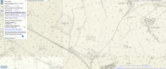
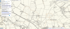
However, in the search process, perhaps unrelated to this line, I discovered an old tramway that used to run parallel to the old railway line, before crossing Firswood Road (I assume a level crossing), formerly known as Coal Pit Lane, before turning north, parallel to the west of Firswood Road, along the edge of Stanley Firs Wood (now the paintball course), before coming to a bizarre abrupt, without reaching Spa Lane.
It doesn't really make any sense, what the purpose of it was. I'm almost more fascinated by this than the line to Lathom, because the route I described above (from 1909) actually changes as we get to the 1953 map.
Here, the route is the same east of Firswood Road, but instead of turning north after crossing the road, stays adjacent to the railway line, before turning north to the WEST of Stanley Firs, as opposed to the east, before again coming to an abrupt end seemingly in the middle of nowhere, with nothing at the end of it.
So all of this begs the question... which route was correct?! And if both maps are correct, then why did the route change between 09 and 53?!
Could it be that part of the tramway (in the 1909) version was a pre-cursor to the Lathom Park line? The direction is certainly appropriate, and there are still land scars on the satellite imagery to half-prove this old tramway did indeed exist. But the 1953 version is less clear, with no signs of the route left-over from satellite imagery, unless of course it has been swallowed up by the farmland.
There is another 1950s OS map that supports the 1909 route, and another from 1955 that supports the 1953 version, so I'm really at a loss as to what really went on here! The only thing that gives the 1953 route a bit more weight is that the 1955 version shows the tramway leading directly to a Sand Pit, west of Stanley Firs. The line completely vanishes from all OS Maps (that I can tell) after this date.
I attach all maps as outlined above for your perusal.
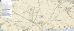
Back to the line in question... the line to Lathom Hall.
Assuming the mysterious tramway has nothing to do with this line, purely going off existing land scars still visible on satellite imagery, I attach a fifth map showing what I believe it's potential route may have been. However, this is just my stab in the dark, and it also takes into account the excerpt from the St Helens Star, although Samples Farm would appear to be an error. I would assume they are referring to Spa Farm?
I'd be interested to know the exact locations of the huts you photographed, and where they are in relation to my suspected route.
One final point: the assumption is that it was a narrow gauge railway. Do you not think it would have just been a tramway?
It seems bizarre for there to be literally no remains or records of this line for it to have been a standard railway. Even narrow gauge. This is why I believe it must have been a tramway.
Failing all of this, maybe there never was a line to the hall and it's all just Chinese Whispers! I.e. the horses disembarked at Ormskirk Station and trotted to Lathom via Crane's Lane!
All thoughts are welcome. On both lines. I'm really intrigued by them.
Since the post at the beginning of this thread I have discovered more about the Lathom House Remount Railway, helped particularly by two excellent publications:
1. HORSES FOR THE WAR: THE STORY OF THE WORLD WAR 1 REMOUNT DEPOT AT LATHOM PARK, LATHOM, LANCASHIRE (available from the Lathom Park Trust, I think from their website).
2. THE WAR HORSES OF LATHOM PARK (A.J. WATTS) available from The Lancashire and Yorkshire Railway Society,
www.lyrs.org.uk).
These have helped me to walk some of the (mainly invisible) line that existed from about 1915-1921, or at least have a go! They're also good on rolling stock and speculative maps.
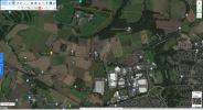
The only place where I believe some physical evidence of the line remains is in private farm land near Lathom House (and is therefore pretty inaccessible). No. 2 above is especially helpful in working out where the line branched near the old sandwash sidings, north of Skelmersdale station on the Ormskirk line (it also contains a grainy copy of the only known photo of horses being unloaded from a train at Lathom).
The line then continued north north west, crossing Old Engine Lane and Slate Lane, then running parallel to Firswood Lane (Coal Pit Lane, as was). There is a wooded embankment to the east of Firswood Lane which more or less marks the path the railway must have followed. You can walk over it near the north end of Firswood Lane, into the large accidental wildlife haven, originally created (like the embankment, I suppose) as space for an industrial estate.
There would have been a level crossing over Spa Lane, with the path of the line following the east side of a linear wood that leads to the perimeter wall of Lathom Park. Apparently you can work out where the railway 'broke through' the old wall, from the repairs done to it in the 1920s.
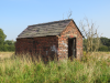
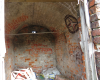
Book 1 above solved the mystery of the building in my original post: it is a powder hut, the only surviving building from the long-closed Old Engine Pit. The pit had shut by the time the Lathom line opened, but given that the hut is close to where a passing loop was added, it's hard to believe that it wasn't used by railway workers at one time or another.
Two current issues to note: the land between Old Engine Lane and Slate Lane (where the powder hut can be found) is destined for residential development. Presumably that's why it wasn't farmed in the summer of 2020. Fortunately, there appears to be a preservation order for the hut which I suppose will one day find itself in pride of place in a housing estate.
Also: the Station Tavern in Old Skelmersdale (previously The Station Hotel) would have been known to many who worked at the Remount Depot. It stands close to the site of Skelmersdale Station, but is shortly to be/ has already been demolished.
These unobtrusive parts of our local landscape hold some important heritage.
The information about the tramway was new to me, and fascinating, not least because it's still there in the latest map. As posted elsewhere, this may have been for coal, but the previously-mentioned (now disappeared) sandwash sidings might suggest that this line was for the transportation of sand?