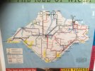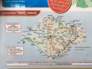
Last week I had the pleasure to visit the Isle of Wight bus museum in Ryde. Most fascinating was the display of old maps, showing how the Southern Vectis network looked in the years before Go-Ahead took over the company. Today’s network is heavily focused on a hub and spoke system centered around Newport, but pre-2006 many services were much longer, and from the maps attached I can make out how the following routes have changed over time:
Buses from Cowes always used to extend to Ryde, Bembridge, Sandown, Shanklin or Ventnor. Different numbers have been used over the years but these have been generally in the 1-3 and 91-93 series. In later years, these services were branded as “Route Rouge”
There never used to be any through services from Godshill to Brading as per today’s routes 2 and 3. Ryde - Shanklin/Ventnor were served by the 6 and 7 series routes which always continued to Newport via Niton (6) or Freshwater (and then onto Newport) via Military Road (7). Some journeys were routed via Wroxall between Shanklin and Ventnor, which made certain journeys quicker compared to today’s 3 depending on where you were going.
The East Cowes services were largely the same as today (still numbered 4 and 5 back then) with the exception that both routes were combined to provide a through Newport - Ryde journey, albeit with a very long double run via EC. The 1990 map however shows route 4 as extending over the floating bridge to West Cowes and Gurnard, making it one of few local bus routes to make use of a ferry en-route. I’m not sure whether it was quicker than going via Newport though considering that the bus would have had to have waited for the floating bridge.
Newport - West Wight services were branded as “Island Explorer” (routes 7, 7A & 7B) and extended all the way around the island to create a full loop service. The Freshwater - Ventnor - Ryde leg is mentioned above but from Ryde to Newport, buses seemingly went via Havenstreet despite the low height restriction at the railway bridge. I wonder if the restriction previously was more lenient and thus allowed double deckers to pass beneath, or whether single deckers were simply used. IIRC these routes were diverted via Wootton and Staplers sometime between 1999 and 2002.
The balance of services between Newport and Ryde via Wootton was very different compared to today. These were made up of direct through services from Cowes and West Wight, as well as a local service via the housing estates in Wootton and Binstead. Surprisingly all of the direct services went via Staplers, while Fairlee (albeit already having the 4/5 combined service via East Cowes) was left with the longer local route which has seen several numbers during its history - It was the 10 in 1997 but became the 8 in 1999. The original Go-Ahead recast in 2006 must have been the first time that both the Fairlee and Staplers roads were provided with a regular interval service equal to each other.
Curiously, there was also a Newport - Ryde route which extended up the length of Ryde pier. I’m guessing the pier must have had a higher weight restriction back then or minibus vehicles were used, or both.
But overall, the route numbers back then were not much different compared to today, albeit with more suffixes used. It seems that the past network provided a lot more cross-Newport journey opportunities without changing, although at the expense of reliability due to the chronic congestion in the area at peak times. I think it is really fascinating to see how the network has changed over time, and would be interested to find out if any other members have past experiences or gaps in knowledge on the historical Southern Vectis network that they wish to share.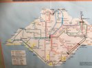