• Our new ticketing site is now live! Using either this or the original site (both powered by TrainSplit) helps support the running of the forum with every ticket purchase! Find out more and ask any questions/give us feedback in this thread!

The optimum GB network

Isambard

Member
Joined
17 Jul 2020
Messages
19
Location
Ashford
A current thread on another part of the forum inspired me to speculate what the network map of the UK would look like had the system been centrally planned from the start, rather than developed piecemeal by often competing companies.
Would it be much the same as we have today, now that many ‘redundant’ lines have disappeared, but without some of the obvious anomalies and duplications?
 
Sponsor Post - registered members do not see these adverts; click here to register, or click here to log in
R

RailUK Forums

HSTEd

Veteran Member
Joined
14 Jul 2011
Messages
18,634
I think there are obviously some places where the inheritance of lines has produced very operationally awkward outcomes.

The Buxton and Hope Valley lines are a bit of a mess.

I wonder if the dominant route to Devon and Cornwall would really be via Reading and Taunton if it was being designed today.
There would likely be a London-Southampton-Bournemouth railway, and if yo are starting from scratch, might it not be better to start west from Bournemouth?

It's a long way from Newbury to Taunton through not particularly heavily populated terrain, whereas there is a bit more traffic potential between Bournemouth and Dorcehster/Weymouth, in my view?
 

Dr Hoo

Established Member
Joined
10 Nov 2015
Messages
4,765
Location
Hope Valley
A current thread on another part of the forum inspired me to speculate what the network map of the UK would look like had the system been centrally planned from the start, rather than developed piecemeal by often competing companies.
Would it be much the same as we have today, now that many ‘redundant’ lines have disappeared, but without some of the obvious anomalies and duplications?
The network was developed mainly for freight but is now mainly passenger. It was developed when developments in traction and braking didn’t permit gradients and speeds that are possible today. The economy has grown far beyond what was there in 1840.
What would have been the basis for the ‘master plan’?
 

Technologist

Member
Joined
29 May 2018
Messages
231
A current thread on another part of the forum inspired me to speculate what the network map of the UK would look like had the system been centrally planned from the start, rather than developed piecemeal by often competing companies.
Would it be much the same as we have today, now that many ‘redundant’ lines have disappeared, but without some of the obvious anomalies and duplications?

It would depend on when this centralised planning was done, who was doing it and what the objectives were.

I'd suggest that if you were to do this today with the objective of improving the economy you'd probably treat the railway lines in England at least as a very large underground/cross rail system. For example Tottenham Court Rd has twice the entries and exits of Birmingham New St with only two platforms to BNS's twelve.

You'd then reconfigure the existing railways into smaller regional high frequency railways and use transit oriented development to fund them. This is basically the Japanese approach, simplify the operating patterns so that most railways are not mixed traffic, up the service frequency till the capacity is massive and then build houses near the stations to take advantage of this.
 

30907

Veteran Member
Joined
30 Sep 2012
Messages
20,617
Location
Airedale
I think there are obviously some places where the inheritance of lines has produced very operationally awkward outcomes.

I wonder if the dominant route to Devon and Cornwall would really be via Reading and Taunton if it was being designed today.
Possibly not, but it didn't exist until the beginning of the C20th - the route was via Bristol.
There would likely be a London-Southampton-Bournemouth railway, and if yo are starting from scratch, might it not be better to start west from Bournemouth?
In 1840 Bournemouth was an unimportant village. Dorchester merited a railway (which was planned to extend to Exeter, yes, but it would have been as long as the route via Bristol and probably slower).
 

Bletchleyite

Veteran Member
Joined
20 Oct 2014
Messages
104,203
Location
"Marston Vale mafia"
The problem with this discussion is that the way towns and cities have grown up in the UK is very heavily influenced by the railway we have and had. Without it they may have grown very differently, both in location and in their own nature. In particular London as it is simply wouldn't work without the railway.
 

etr221

Established Member
Joined
10 Mar 2018
Messages
1,345
There is a book "The World's First Railway System: Enterprise, Competition, and Regulation on the Railway Network in Victorian Britain" by Professor Mark Casson (pub OUP 2009), which includes a description of a counter-factual railway network, giving similar benefits (i.e. linking the same places), but about 2/3rds the size (13,000 v 20,000 route miles) compared to that which was built - and substantially different: it started from scratch on a map of early Victorian Britain, linking the cities and towns as they were, i.e. a network designed for the Britain of 1840. About 2,000 miles were routes not built in reality...

Note: an academic textbook, so not cheap...
 

Bletchleyite

Veteran Member
Joined
20 Oct 2014
Messages
104,203
Location
"Marston Vale mafia"
There is a book "The World's First Railway System: Enterprise, Competition, and Regulation on the Railway Network in Victorian Britain" by Professor Mark Casson (pub OUP 2009), which includes a description of a counter-factual railway network, giving similar benefits (i.e. linking the same places), but about 2/3rds the size (13,000 v 20,000 route miles) compared to that which was built - and substantially different: it started from scratch on a map of early Victorian Britain, linking the cities and towns as they were, i.e. a network designed for the Britain of 1840. About 2,000 miles were routes not built in reality...

Note: an academic textbook, so not cheap...

Also quite dry to read. I did buy a copy a while back but didn't find it very enjoyable to read, though I was able to resell it for a similar price I bought it for (about 40 quid if I recall).
 

Sad Sprinter

Established Member
Joined
5 Jun 2017
Messages
2,582
Location
Way on down South London town
I'd probably:

Alter the WCML to run via the GWR/GCR joint line
Run the Midland up via the existing West Coast towards Northampton before continuing northwards to Leeds/Bradford
Get rid of the ECML and build a new London - Cambridge - Lincoln - Goole - York trunk line

I'd probably run wide, high capacity corridors through the centres of Birmingham, Manchester and Leeds rather than have the main line avoid those places.
 

MarlowDonkey

Established Member
Joined
4 Apr 2013
Messages
1,403
It would depend on when this centralised planning was done, who was doing it and what the objectives were.
A possible approach would have been to insist on one major station per major town or city as developed in Germany and other counties.

It might not be possible to just have one in London, but I think it could be reduced to three. These would be "Euston" being Paddington, Marylebone, Euston, Kings Cross and St Pancras. "Westminster" being Victoria, Waterloo, and Charing Cross."City" being Moorgate, Liverpool Street, Broad Steet, Cannon Street, Fenchurch Street and London Bridge.
 

A S Leib

Established Member
Joined
9 Sep 2018
Messages
2,036
It might not be possible to just have one in London, but I think it could be reduced to three. These would be "Euston" being Paddington, Marylebone, Euston, Kings Cross and St Pancras. "Westminster" being Victoria, Waterloo, and Charing Cross."City" being Moorgate, Liverpool Street, Broad Steet, Cannon Street, Fenchurch Street and London Bridge.
The first group currently has 63 terminating platforms; the second has 49, and the third has 38 (including Blackfriars), although of course in this scenario that might be very different; maybe more of the current Euston Road services would go to the Square Mile terminus instead?
 

Horizon22

Established Member
Associate Staff
Jobs & Careers
Joined
8 Sep 2019
Messages
9,385
Location
London
The issue with doing this exercise is that in many places the railway itself has led to the growth of towns and attracted investment / jobs and housing. It's hard to detatch the last 150 years of geographic and demographic change from the impact the railway had.
 

TheWierdOne

Member
Joined
30 Oct 2020
Messages
98
Location
Cymru
A possible approach would have been to insist on one major station per major town or city as developed in Germany and other counties.

It might not be possible to just have one in London, but I think it could be reduced to three. These would be "Euston" being Paddington, Marylebone, Euston, Kings Cross and St Pancras. "Westminster" being Victoria, Waterloo, and Charing Cross."City" being Moorgate, Liverpool Street, Broad Steet, Cannon Street, Fenchurch Street and London Bridge.
If we assume that we have the Victorian approach to building, but the backing of the national purse and politics, you can absolutely get down to two I reckon.

London East could take most of the lines from Kent, that currently run into Charing Cross and Cannon Street, as well as Fenchurch, Liverpool Street, and the Great Northern services out of Kings Cross.

London West could take everything else.

Edit: Sited at Liverpool/Fenchurch and Kensington Olympia respectively
 

Horizon22

Established Member
Associate Staff
Jobs & Careers
Joined
8 Sep 2019
Messages
9,385
Location
London
If we assume that we have the Victorian approach to building, but the backing of the national purse and politics, you can absolutely get down to two I reckon.

London East could take most of the lines from Kent, that currently run into Charing Cross and Cannon Street, as well as Fenchurch, Liverpool Street, and the Great Northern services out of Kings Cross.

London West could take everything else.

Edit: Sited at Liverpool/Fenchurch and Kensington Olympia respectively

Those would be monster stations - the amount of platforms to combine everything from Waterloo / Victoria / Paddington would be difficult for even Victorian london. Not to mention you probably need a north facing station which is going to have some of the longest services just based on geography.

Realistically I think it might be something like:

London Westminster (Victoria / Waterloo / Charing Cross [if it even exists] - serving the Southern counties
London City (Cannon Street / Fenchurch St / Liverpool Street) London Bridge just a through station - service the Eastern counties / some of the South East
London Marylebone (Paddington / Marylebone / part Euston) - serving Wales / West / some North West (GWML and WCML)
London Kings Cross (Kings Cross / Moorgate / St Pancras / part Euston) - serving North / North East / Scotland (ECML and MML)

I wonder if any would have been built south of the River. There certainly might have been more space to build the Westminster one there as an example.

Then have a RER type service going North-South and East-West (sort of like Thameslink and Crossrail) connecting these termini.
 
Last edited:

TheWierdOne

Member
Joined
30 Oct 2020
Messages
98
Location
Cymru
Those would be monster stations - the amount of platforms to combine everything from Waterloo / Victoria / Paddington would be difficult for even Victorian london.

Realistically I think it might be something like:

London Westminster (Victoria / Waterloo / Charing Cross [if it even exists] - serving the Southern counties
London City (Cannon Street / Fenchurch St / Liverpool Street) London Bridge just a through station - service the Eastern counties and South East London
London Marylebone (Paddington / Marylebone / part Euston) - serving Wales / West / some North West (GWML and WCML)
London Kings Cross (Kings Cross / Moorgate / St Pancras / part Euston) - serving North / North East / Scotland (ECML and MML)

Then have a RER type service going North-South and East-West (sort of like Thameslink and Crossrail) connecting these termini.
Oh they would be absolutely vast. London West would likely be a T-shaped station, with a North-South through station and a West facing sector to cater for Paddington and some Waterloo traffic.

London East would probably be fully North South but with some very sharp east facing chords at near both throats.

I don’t doubt the Victorians would’ve done this or something similar if not for commercial differences. The Tube lines between them may well have been built four track given they would’ve been incredibly busy from the outset.
 

Sir Felix Pole

Established Member
Joined
21 Oct 2012
Messages
1,360
Location
Wilmslow
France centrally planned its railway system, letting out long-term concessions to private companies to operate them. It didn't end up with one mega Paris station, however. There were very few competing lines - Paris / Versailles is one exception that remains today. Bordeaux had two competing lines to Paris but the État line was promptly downgraded (and parts eventually closed) when SNCF was formed and took over in 1938.
 

Nottingham59

Established Member
Joined
10 Dec 2019
Messages
2,643
Location
Nottingham
This is what was planned in 1965, plus commuter lines into the big cities and especially London.
364px-Beeching2_clear.svg.png

[Image of lines selected for further development in Beeching II]
 

Technologist

Member
Joined
29 May 2018
Messages
231
The first group currently has 63 terminating platforms; the second has 49, and the third has 38 (including Blackfriars), although of course in this scenario that might be very different; maybe more of the current Euston Road services would go to the Square Mile terminus instead?

In my UK rail network as a massive underground I wouldn't terminate any train in London I'd run everything as a Cross Rail/Thameslink. The Intercity lines would either cross the city or given that there are far more destinations to the north than the south some would go in the centre and then loop out.
 

philosopher

Established Member
Joined
23 Sep 2015
Messages
1,443
I'd probably:

Alter the WCML to run via the GWR/GCR joint line
Run the Midland up via the existing West Coast towards Northampton before continuing northwards to Leeds/Bradford
Get rid of the ECML and build a new London - Cambridge - Lincoln - Goole - York trunk line

I'd probably run wide, high capacity corridors through the centres of Birmingham, Manchester and Leeds rather than have the main line avoid those places.
To add to this, I would have the Midland Mainline routed through Nottingham rather than Derby. After Leeds it would continue north of Newcastle and then to Edinburgh.
 

WibbleWobble

Member
Joined
19 Aug 2022
Messages
454
Location
.
In 1840 Bournemouth was an unimportant village. Dorchester merited a railway (which was planned to extend to Exeter, yes, but it would have been as long as the route via Bristol and probably slower).
What was the population of Dorchester back then? Poole was possibly the largest settlement (just shy of 10k) due to the port, Weymouth being about half the size.

Bournemouth was small but was being developed as a spa resort. The town grew massively because of the arrival of the railways. A line being planned in 1840 would have had the same result once built, the growth just occurring 30 years earlier than reality.
 

Dr Hoo

Established Member
Joined
10 Nov 2015
Messages
4,765
Location
Hope Valley
This is what was planned in 1965, plus commuter lines into the big cities and especially London.
364px-Beeching2_clear.svg.png

[Image of lines selected for further development in Beeching II]
The Network for Development was just the subset of lines chosen for upgrade to handle a hoped-for 75% increase in trunk freight over the next 20 years. It wasn’t a plan for any further closures.
In any event, it obviously started with what was there after c.130 years of railways rather than being a 19th Century strategic vision before a lot of industrial development had taken place.
 

Sad Sprinter

Established Member
Joined
5 Jun 2017
Messages
2,582
Location
Way on down South London town
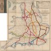
Although I really have other things I need to do. Here's a quick map I drew up with an ancient railway map from the 1840s displaying what a possible centrally planned railway system could look like:

Red: Western System
Orange: Central System
Brown: Eastern system
Green: Bristol System
Blue: South Western System
Red: Southern System


Map.jpegMap.jpeg
 

etr221

Established Member
Joined
10 Mar 2018
Messages
1,345
Although I really have other things I need to do. Here's a quick map I drew up with an ancient railway map from the 1840s displaying what a possible centrally planned railway system could look like:
Interestingly, there is another version of that (Cheffin's) map, also with then projected railways (I assume at the same date of 1843) - see at https://curtiswrightmaps.com/product/cheffins-map-of-the-english-scotch-railways/.

Stepping back a bit, the reason we do have (and had) a sub-optimal network, is that in Britain railways were built by numerous private and independant companies - with realtionships ranging between close co-operation to bitter rivalry, as separate projects. For a national optimalised network, a 'directing mind' is required, probably requiring a nationalised, state, system - and it was at about that time (early 1840s) that that concept was first seriously proposed - with powers included in the 1844 Railway Regulation Act. So the most likely possible system that might have come about is one built on the network as it was in about 1845.

The other thing to consider is that the principle trunk(s) of any optimalised system would be the mainline(s) from London to the North: and the geography of Britain is such that the principle cities in the midlands, north and Scotland can be reached from a single line out of London. Whether that be the London and Birmingham of the Euston Square confederacy (eventually joined/relieved by five others), or, 180 years later, HS2. But one line does will not provide enough capacity... (cf also the motorway network, now with three such (M1, M40, A1(M)).
 

Meerkat

Established Member
Joined
14 Jul 2018
Messages
9,236
How many competing routes were actually not necessary for capacity at some point in their existence, certainly of the main lines? Settle and Carlisle is an obvious one that wouldn’t have been built, but it’s absence would have restricted overall England-Scotland capacity.
During the period before significant road transport even competing lines connected intermediate places that would often need connecting somehow, though presumably large areas would have had no railways if the government was making investment decisions (unless social subsidies started a century earlier)?
There’s also the question of how much power the directing authority had. Were they just choosing between alternative private proposals or central government planning as per the motorways (and HS2)? And if they were state planners would they have had the power to overrule landowners and local authorities - ie could they have ignored London councils and ploughed through lines across with through stations where they crossed?
 

eldomtom2

On Moderation
Joined
6 Oct 2018
Messages
1,926
It wasn’t a plan for any further closures.
The Report explicitly stated that part of the motive for publishing the Network for Development was so that future closure proposals could be viewed in context.
 

Mikey C

Established Member
Joined
11 Feb 2013
Messages
7,557
I imagine that instead of having partial duplicates of routes, there would be more 4 or 6 tracking of one main route.

The GWR network might make more sense with a 4 track mainline London-Bristol TM (6 track to Didcot), splitting to go to Cardiff or Exeter etc Maybe Bath would be on a branchline instead of the mainline.
 

PTR 444

Established Member
Joined
22 Aug 2019
Messages
2,413
Location
Wimborne
I imagine that instead of having partial duplicates of routes, there would be more 4 or 6 tracking of one main route.

The GWR network might make more sense with a 4 track mainline London-Bristol TM (6 track to Didcot), splitting to go to Cardiff or Exeter etc Maybe Bath would be on a branchline instead of the mainline.
You could argue that Bath is on a branch line now, since the GWML bypasses it to go on to South Wales. Even going from London to Bristol is faster via Filton, although such a service hasn’t operated since the pandemic.

Perhaps if the GWML was being started from scratch now, it would run via Basingstoke and Devizes to Bath and Bristol, before splitting into South West and South Wales branches. If that was possible in the 19th century, Swindon might have never grown to be a major town.
 

quantinghome

Established Member
Joined
1 Jun 2013
Messages
2,414
The most notable difference with a centrally planned network would be likely have been better connectivity rather than the routes themselves. We would have had a single very large hauptbahnhof-style station in each city rather than the patchwork we ended up with. London would have had perhaps half a dozen larger stations. And we wouldn't have had the farce of secondary routes like the Varsity line having no through services.
 

Turtle

Member
Joined
18 Mar 2013
Messages
402
I imagine that instead of having partial duplicates of routes, there would be more 4 or 6 tracking of one main route.

The GWR network might make more sense with a 4 track mainline London-Bristol TM (6 track to Didcot), splitting to go to Cardiff or Exeter etc Maybe Bath would be on a branchline instead of the mainline.
And a 6 track /4 track main line to Brighton rather than the current 4/2 arrangement. A pity the money has never been available to at least make it 4 track from Three Bridges.
 

MarlowDonkey

Established Member
Joined
4 Apr 2013
Messages
1,403
I imagine that instead of having partial duplicates of routes, there would be more 4 or 6 tracking of one main route.
How many of the main lines out of London are six track?

Two immediately spring to mind

Marylebone/Baker Street to Wembley Park - though that's three parallel routes, Chiltern, Metropolitan and Jubilee.
Euston to Watford being 4*WCML and 2*DC lines.

Others?
 

Top