alxndr
Established Member
- Joined
- 3 Apr 2015
- Messages
- 1,489
From another current thread, I see there’s a NR level crossing map and spreadsheet here:
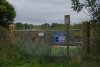
...and I now think their own data for Odd Lane UWC is wrong.
Level crossing safety - Network Rail
Our programme for level crossings safety and guides to help people use them correctly, including an nteractive map for level crossings.www.networkrail.co.uk
(Which probably likely explains what I wrote in post #56 earlier.)
From their spreadsheet data for Odd Lane:
The lat/long is 51.36642,-1.043628
and the miles/yards 43.1236 which would be 43m 56ch.
That seems to be pointing to the under bridge much nearer Mortimer station?
Is there a chance please that someone could double check things and see if I’m making some sort of beginners mistake? If I’m right I’ll let NR know using the procedure on that webpage.
I agree that the data does seem to be incorrectly pointing towards the underbridge when it should be further south.