Noticed that various works seem to have started at Bath Spa station, but can find no information about them. (Googling “Bath Spa refurbishment” just brings up articles about the 2017 works). Anyone know what’s being done?
-
Our booking engine at tickets.railforums.co.uk (powered by TrainSplit) helps support the running of the forum with every ticket purchase! Find out more and ask any questions/give us feedback in this thread!
You are using an out of date browser. It may not display this or other websites correctly.
You should upgrade or use an alternative browser.
You should upgrade or use an alternative browser.
Bath Spa refurbishment?
- Thread starter The exile
- Start date
- Status
- Not open for further replies.
Sponsor Post - registered members do not see these adverts; click here to register, or click here to log in
R
RailUK Forums
What are Passenger Awareness Monitors? Is this another name for PIS/CIS screens or something different.They have received planning permission for Passengers awareness monitors to be installed
urpert
Member
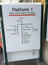
That should probably be in a museum rather than on the platform! It’s one of the most confusing things I’ve ever seen. Does it not suggest that all trains to the north reverse at both Gloucester and again at Great Malvern, Cheltenham is not a significant stop and all trains to the South West stop at Weston-super-Mare? Wales isn’t even mentioned and yet Newport and Cardiff are shown.I hope it doesn’t lead to the loss of this:
(Image shows an unusual line diagram)
urpert
Member
I also love the idea that The North is everything beyond Great Malvern.
fgwrich
Established Member
They have received planning permission for Passengers awareness monitors to be installed
Presumably this is a passenger counting type system? It will certainly be very busy on a Friday and Saturday night - the busiest part of the week for Bath Spa station!
I hope it doesn’t lead to the loss of this:
(Image shows an unusual line diagram)
That's awful - I really hope that isn't a new design and part of this new GBR typeface thing?
urpert
Member
Certainly not new (I took that picture in 2014 and the style looks like very early pre-pink Great Western).Presumably this is a passenger counting type system? It will certainly be very busy on a Friday and Saturday night - the busiest part of the week for Bath Spa station!
That's awful - I really hope that isn't a new design and part of this new GBR typeface thing?
Mikey C
Established Member
- Joined
- 11 Feb 2013
- Messages
- 6,857
And that the South West only starts after Exeter!I also love the idea that The North is everything beyond Great Malvern.
swt_passenger
Veteran Member
- Joined
- 7 Apr 2010
- Messages
- 31,448
Brings to mind old Southern route diagrams above carriage doors that had Southampton only a short hop from Milton Keynes…That should probably be in a museum rather than on the platform! It’s one of the most confusing things I’ve ever seen. Does it not suggest that all trains to the north reverse at both Gloucester and again at Great Malvern, Cheltenham is not a significant stop and all trains to the South West stop at Weston-super-Mare? Wales isn’t even mentioned and yet Newport and Cardiff are shown.
modernrail
Member
- Joined
- 26 Jul 2015
- Messages
- 1,055
I have always been amused at any use of ‘The North’ on signs. Like it is a place. I can’t imagine many countries use that type of shorthand on signs. The use of compass points is beautifully London centric. You don’t see signs east of the Pennines saying ‘The West’ or vice versa.
I can imagine the signage manual saying something like - use ‘The North’ to assist the Kings troops needing to quell a rebellion/to signify the part of the country the Government can’t really be arsed with.
I can imagine the signage manual saying something like - use ‘The North’ to assist the Kings troops needing to quell a rebellion/to signify the part of the country the Government can’t really be arsed with.
urpert
Member
I’m always fascinated by the signs which appear at junctions roughly between Peterborough and York on the A1 which sayI have always been amused at any use of ‘The North’ on signs. Like it is a place. I can’t imagine many countries use that type of shorthand on signs. The use of compass points is beautifully London centric. You don’t see signs east of the Pennines saying ‘The West’ or vice versa.
I can imagine the signage manual saying something like - use ‘The North’ to assist the Kings troops needing to quell a rebellion/to signify the part of the country the Government can’t really be arsed with.
<- THE SOUTH
THE NORTH ->
There’s even one somewhere in Yorkshire that says NORTH & SOUTH (A1)
I’m always fascinated by the signs which appear at junctions roughly between Peterborough and York on the A1 which say
<- THE SOUTH
THE NORTH ->
There’s even one somewhere in Yorkshire that says NORTH & SOUTH (A1)
It just simplicities' sake for the user. People travelling long distance only need the general info until they close enough and filter off.
modernrail
Member
- Joined
- 26 Jul 2015
- Messages
- 1,055
I love a map and a compass point and so I quite like it if it used consistently (which it definitely isn’t on the railway and arguably isn’t on the roads). However, I do wonder what proportion of the population finds it useful as lots of people don’t really work in compass point mode.
As ever with signage I suspect there is no perfect answer.
My Dad is a massive fan of the way the French use ‘all directions’ and ‘other directions’
Compass points can also be confusing even for a map fan. I often have to work my brain up a gear when using the Circle Line and in a couple of other places when thinking what is Westbound and Eastbound etc.
I think the map at Bath shows how hard it is to show a map of rail routes in an east to digest form. Some maps used on the railways are even worse. The Southern map above the doors on trains and on some stations is verging on useless, as were the maps used by Virgin for its routes. For instance, if you are going to number routes you really need to go for it, it needs to be on the map, train, info displays on platforms etc. That is rarely the case in the UK and so passengers just don’t have a chance to become familiar with it and for it to be useful.
Even on systems like Merseyrail the term Northern Line is rarely used by passengers whereas in London it has really stuck. A Merseyside passenger would usually say ‘The Southport train’ whereas a London passenger would never say ‘The Morden train’.
The most disgusting thing about the map in #4 is that it doesn't even preserve clockwise order.
If they particularly wanted to have Bath at the top then they should have had the SW to the right, south Wales at the bottom, and Parkway and the North to the left.
If they particularly wanted to have Bath at the top then they should have had the SW to the right, south Wales at the bottom, and Parkway and the North to the left.
They might start to now, to distinguish it from a Battersea-bound Northern Line train.A Merseyside passenger would usually say ‘The Southport train’ whereas a London passenger would never say ‘The Morden train’.
In terms of through trains actually heading in those directions from Bath - with the exception of the suggestion that you can get to "the North" via Great Malvern, it's not far off reflecting the basic service offered in terms of "If you want to go to "x" , don't get on a train heading for "y" - because it won't get you there". Passengers for "the North" who board a Great Malvern train should get announcements about changing for "the North" before 3 different stations (Temple Meads, Parkway and Cheltenham - which being an "InterCity" station is a significant stop (you could in fact argue that it is Gloucester that should be "downgraded" on the map)That should probably be in a museum rather than on the platform! It’s one of the most confusing things I’ve ever seen. Does it not suggest that all trains to the north reverse at both Gloucester and again at Great Malvern, Cheltenham is not a significant stop and all trains to the South West stop at Weston-super-Mare? Wales isn’t even mentioned and yet Newport and Cardiff are shown.
Last edited:
py_megapixel
Established Member
Are Passenger Awareness Monitors those displays which show the CCTV feed in real-time, to warn people that they're being watched (as often seen in supermarkets for example)?
Possibly - whatever the work is, it involves the two waiting rooms (which are the places least likely to be being monitored by staff undertaking their usual duties)Are Passenger Awareness Monitors those displays which show the CCTV feed in real-time, to warn people that they're being watched (as often seen in supermarkets for example)?
modernrail
Member
- Joined
- 26 Jul 2015
- Messages
- 1,055
I find those things so dystopian!! I really hope they don’t take off. I can see why they might work I suppose but it also feels like a step too far.Are Passenger Awareness Monitors those displays which show the CCTV feed in real-time, to warn people that they're being watched (as often seen in supermarkets for example)?
pdeaves
Established Member
Does it not suggest that all trains to the north reverse at both Gloucester and again at Great Malvern.
It's a visual way of representing possible links from the station. It is not, nor is it supposed to be, a geographically correct map. Both have their place but they convey different information and speed of assimilation.The most disgusting thing about the map in #4 is that it doesn't even preserve clockwise order.
It's certainly NOT true that the diagram in #4 is as easy to read as it would be if it were changed as I suggest. As it is it's very disorienting. Destinations are not where you have the right to expect them to be in relation to other destinations.It's a visual way of representing possible links from the station. It is not, nor is it supposed to be, a geographically correct map. Both have their place but they convey different information and speed of assimilation.
A list without any pretence to be a diagram would be clearer.
Would suggest that the people most likely to be confused by the diagram are those who don’t actually need it…It's certainly NOT true that the diagram in #4 is as easy to read as it would be if it were changed as I suggest. As it is it's very disorienting. Destinations are not where you have the right to expect them to be in relation to other destinations.
A list without any pretence to be a diagram would be clearer.
But it is confusing, even to me who knows that area very well, having lived in several places covered by it. How much more confusing it must be to an outsider. I have been staring at it for several minutes trying to understand its logic, if any. It looks like it was drawn by a drunk with a T-square.It's a visual way of representing possible links from the station. It is not, nor is it supposed to be, a geographically correct map.
For example if I were a stranger going from Bath to Gloucester, and had just changed onto another train at Bristol TM as I would have been advised, I would be very concerned about the fact that my new train was leaving the station in the direction I had just come from. I am a great fan of connectivity maps, like the classic LU map, but they need to show some relationship to reality. The LU map for example shows a route reversal where a reversal is needed, and junctions are shown correctly angled and not as right-angled joins.
brad465
Established Member
They did an 'outstanding' job refurbishing the station in 2017 - a restricted service using only 1 platform while each platform was extended outwards for the electrification that still hasn't arrived there. Much like the previous closures in 2015 and 2016 that saw vast track lowering work done through the Box Tunnel, Sydney Gardens, etc., that, while good for replacing end of life track, still hasn't seen its purpose applied.
But it is confusing, even to me who knows that area very well, having lived in several places covered by it. How much more confusing it must be to an outsider. I have been staring at it for several minutes trying to understand its logic, if any. It looks like it was drawn by a drunk with a T-square.
Highly unlikely that you would be changing at Temple Meads as the trains serving Gloucester mostly would have come from Bath in the first placeFor example if I were a stranger going from Bath to Gloucester, and had just changed onto another train at Bristol TM as I would have been advised, I would be very concerned about the fact that my new train was leaving the station in the direction I had just come from. I am a great fan of connectivity maps, like the classic LU map, but they need to show some relationship to reality. The LU map for example shows a route reversal where a reversal is needed, and junctions are shown correctly angled and not as right-angled joins.
Wasn’t the platform widening / lengthening for the IETs (which we have got) rather than the electrification per se. In terms of passenger facilities etc I don’t think anything was done in 2017. I just hope they complete the anti-pigeon spikes…They did an 'outstanding' job refurbishing the station in 2017 - a restricted service using only 1 platform while each platform was extended outwards for the electrification that still hasn't arrived there. Much like the previous closures in 2015 and 2016 that saw vast track lowering work done through the Box Tunnel, Sydney Gardens, etc., that, while good for replacing end of life track, still hasn't seen its purpose applied.
Annetts key
Established Member
Is now a good time to point out a possible route via SwindonHighly unlikely that you would be changing at Temple Meads as the trains serving Gloucester mostly would have come from Bath in the first place
The track (both the Up Main and the Down Main) was moved towards the former old through (middle) road away from the platform edges. Then each platform was extended outwards towards the new track alignment. By doing this, it means that when (if) the OHL is provided, there is enough clearance to the station canopy/roof.Wasn’t the platform widening / lengthening for the IETs (which we have got) rather than the electrification per se. In terms of passenger facilities etc I don’t think anything was done in 2017. I just hope they complete the anti-pigeon spikes…
As far as I can tell, the platform lengths were not changed significantly.
- Status
- Not open for further replies.