• Our booking engine at tickets.railforums.co.uk (powered by TrainSplit) helps support the running of the forum with every ticket purchase! Find out more and ask any questions/give us feedback in this thread!

Black Cat Roundabout upgrade awarded

Status
Not open for further replies.

Ediswan

Established Member
Joined
15 Nov 2012
Messages
2,866
Location
Stevenage
Yes it’s all been remarked out fairly recently (within the last few months). No issues negotiating it before that, now I find it sufficiently problematic that I will try and find a route which avoids it. The basic problem is the lane markings are different to where people seem to naturally drive, which means people cross lanes when they’re not meant to.
I took a look at Google's latest images. I have highlighted two parts of your text - we seem to agree on the first highlight because it avoided the second highlight.

Trouble is, no matter how hatefull it is to negotiate, so long as traffic flow is improved, and no serious accidents occur, it will be deemed a success.
 
Sponsor Post - registered members do not see these adverts; click here to register, or click here to log in
R

RailUK Forums

Mikey C

Established Member
Joined
11 Feb 2013
Messages
6,883
The M1 is awful though. The London end is dire, and the section around Luton is horrendous pretty much any time of day.
The M1 might be horrible north of the M25, and especially going through Luton, but south of the M25 it's a lovely quiet road, and much nicer than using the A1, where you go through a number of roundabouts and traffic lights from Borehamwood onwards, especially when it multiplexes with the A41
 

Spamcan81

Member
Joined
12 Sep 2011
Messages
1,081
Location
Bedfordshire
Very good news.

Bets on as to which of the remaining four will be the last roundabout to survive between Berwick and London, and when it will finally go.

Unfortunately I suspect there may well be a fair few years to wait for that.

Replacing the one at Buckden will be a challenge.
 

Dave W

Member
Joined
27 Sep 2019
Messages
592
Location
North London
The M1 might be horrible north of the M25, and especially going through Luton, but south of the M25 it's a lovely quiet road, and much nicer than using the A1, where you go through a number of roundabouts and traffic lights from Borehamwood onwards, especially when it multiplexes with the A41
Whilst I take the latter point, and yes the M1 south of the M25 is quieter, I wouldn't call it lovely. It's 6 lanes of lawlessness - no speed cameras so the "great and good" of North London drive their greyscale German saloons and 4x4s at appalling rates. As for the local pootlers sitting in the middle lane doing 55...
 

snowball

Established Member
Joined
4 Mar 2013
Messages
7,780
Location
Leeds
Replacing the one at Buckden will be a challenge.
Would probably have to bypass Buckden to the west, on a line diverging from the present A1 (as you go south) immediately after the new A14 northbound flyover. They've rather tied their hands there by the design of the A14 scheme. In the 1990s there was a proposal for a longer diversion of the A1.
 

ABB125

Established Member
Joined
23 Jul 2016
Messages
3,781
Location
University of Birmingham
Would probably have to bypass Buckden to the west, on a line diverging from the present A1 (as you go south) immediately after the new A14 northbound flyover. They've rather tied their hands there by the design of the A14 scheme. In the 1990s there was a proposal for a longer diversion of the A1.
It would certainly be possible to build an S-shape curve immediately south of the A14 sliproad overbridge and head to the west of Buckden. Park Farm would likely have to go. A major overhaul of the B1514 junction would be required, probably with this becoming the main access point for Buckden. This would then allow the new A1 to be a proper bypass, with no junctions in the middle.
 

D365

Veteran Member
Joined
29 Jun 2012
Messages
11,503
The Black Cat roundabout was changed fairly recently, whether it was an upgrade is a matter of opinion :)
Traversing the Black Cat took me less than five minutes when I used to commute from Cambridgeshire to Bedfordshire. But I was lucky to never have the misfortune of total carnage.

Would probably have to bypass Buckden to the west, on a line diverging from the present A1 (as you go south) immediately after the new A14 northbound flyover. They've rather tied their hands there by the design of the A14 scheme. In the 1990s there was a proposal for a longer diversion of the A1.
Compared to the 2013 plans, the final implementation of the A1/A14 dual alignment actually makes it easier to divert the A1 for a west of Buckden bypass.

Does anyone have access to A1 proposal documents from the 1990s? Local councillors have referenced the Buckden plans, I would be interested to see the alignment that was proposed.
 

D365

Veteran Member
Joined
29 Jun 2012
Messages
11,503
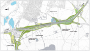
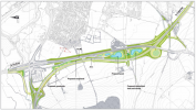
From a design point-of-view, I actually prefer the old plans. It has a 300-ish degree loop!!
Comparison here:
Given that the loop would have been my commute between Cambridgeshire and "The North", I'm rather glad that it didn't happen!

The end result makes sense in that the land use is significantly reduced.
 

snowball

Established Member
Joined
4 Mar 2013
Messages
7,780
Location
Leeds
Does anyone have access to A1 proposal documents from the 1990s? Local councillors have referenced the Buckden plans, I would be interested to see the alignment that was proposed.
I have a printed leaflet of them but it might be a mammoth job to find it.

I seem to remember they were posted on SABRE some time within the last 10 years. I'll try to find them there.

Edit: I haven't yet found where the plans were posted on SABRE, but I've found a post from 2010 where I described the route on SABRE:

I've found my copy of the 1994 consultation leaflet on Baldrick-Alconbury. Going S to N, it passes east of the motel near Astwick, then is close to the A1 as far as where the Biggleswade bypass crosses the A6001. From there it remains west of the A1 until near Brampton, where it becomes online. Its two most westerly points, both with an easting of about 14.3, are where it passes W of Blunham and again east of Brook Farm, WNW of Wyboston.

There's a junction at the south end of Biggleswade, another SW of Black Cat (with the then-proposed GB bypass), and then what I assume is basically the existing junction at Brampton. It would have been D3M south of the Biggleswade junction, then D2M. Junction types are not shown but I guess nothing 3-level.

No doubt the section of bypassed A1 between the Black Cat and the St Neots bypass would have become A428 (or 1).

There's a smaller scale map showing numerous rejected alternative routes. The only things they have in common are that they all pass W of Biggleswade, and they are all online again in time for the crossing of the A14.

The easting of 14.3 km can be checked on any relevant OS paper map or any online mapping site that can show OS maps, such as streetmap.co.uk .

GB = Great Barford.
 
Last edited:

D365

Veteran Member
Joined
29 Jun 2012
Messages
11,503
I have a printed leaflet of them but it might be a mammoth job to find it.

I seem to remember they were posted on SABRE some time within the last 10 years. I'll try to find them there.
I've found one page of the A1 Baldock-Alconbury consultation flyer here, but no luck finding the maps described (blue and black routes).

A SABRE user has provided a description of the route, but no images from them unfortunately.
 

bspahh

Established Member
Joined
5 Jan 2017
Messages
1,750
That's me and exactly as quoted in #71.

I've now found the other SABRE event I was remembering. In September 2016, SABRE user c2R found this link, but it no longer works:


I did a google search for

staploe parish council
and found http://www.staploe-pc.gov.uk

I then did a google search for this:

site:staploe-pc.gov.uk highways-and-a1 2016

which finds https://staploe-pc.gov.uk/highways-rail-and-infrastructure/a1-east-of-england-study/
which has a link to this 131 page PDF file
 

snowball

Established Member
Joined
4 Mar 2013
Messages
7,780
Location
Leeds
That document includes a brief description of the 1990s proposal but I think not a map. In 2016 the staploe parish site included a reproduction of the 1994 leaflet.
 

bspahh

Established Member
Joined
5 Jan 2017
Messages
1,750
That document includes a brief description of the 1990s proposal but I think not a map. In 2016 the staploe parish site included a reproduction of the 1994 leaflet.
This search
site:staploe-pc.gov.uk highways a1 1994
Gets this page
where the links are broken.

However, if I then search for the file names from those links, then they are available:

"a1-upgrade-1994-proposals-1.pdf"

"a1-upgrade-1994-proposals-2.pdf"

"A1-upgrade-1994-proposals-St-Neots-map.pdf"

"A1-upgrade-1994-proposals-Sandy-and-Biggleswade-map.pdf"
 
Last edited:

ABB125

Established Member
Joined
23 Jul 2016
Messages
3,781
Location
University of Birmingham
That's very interesting, thanks!
The second link you posted doesn't work, however this one does:
 
Status
Not open for further replies.

Top