• Our new ticketing site is now live! Using either this or the original site (both powered by TrainSplit) helps support the running of the forum with every ticket purchase! Find out more and ask any questions/give us feedback in this thread!

British Railways Operators Map

alexh2o

New Member
Joined
6 Aug 2019
Messages
2
Hi all,

I made a map. It started just because I wanted to see how all the TOCs' networks linked together like a national scale Underground map, but couldn't find anything up to date that came close. I got a bit carried away and it grew and grew. Now more hours than I'll ever admit later and I'm not sure what to do with it! Except share it and hope others enjoy it.

So here's the British Railways Operators Map.

Let me know if you spot any errors and happy to hear suggestions for corrections/improvements. I'll probably collect all the amendments and do one big update at some point. Maybe one day I'll keep going north but that's it for now!

Also if you're feeling really nice, you can buy me a coffee/beer (ko-fi link on the map), which would be hugely appreciated...

Enjoy,
Alex
 

Attachments

  • British Railways Operators Map (version 06-2025).pdf
    1.7 MB · Views: 998
Sponsor Post - registered members do not see these adverts; click here to register, or click here to log in
R

RailUK Forums

Starmill

Veteran Member
Joined
18 May 2012
Messages
25,360
Location
Bolton
A very impressive piece of work drawing that all out like that!!

If you're interested in the tiny details, the service between Ellesmere Port and Helsby is limited and the Avanti West Coast service between Wolverhampton and Shrewsbury no longer runs.
 

Lewisham2221

Established Member
Joined
23 Jun 2005
Messages
2,240
Location
Staffordshire
Very nice. A couple of minor points though:
  • The ferry connection should be at Newhaven Town, not Newhaven Harbour.
  • AFAIK there's no public transport connection between East Midlands Parkway and the airport, the recommended "official" connection is Derby.
 

Horizon22

Established Member
Associate Staff
Jobs & Careers
Joined
8 Sep 2019
Messages
9,560
Location
London
Also not sure why, but the Southend and Southminster branches on Greater Anglia have deviated from the green used for the rest of GA to a blue.
 

357

Established Member
Joined
12 Nov 2018
Messages
1,913
There seems to be some operators missing, at least three Open Access aren't on there
 

AlterEgo

Verified Rep - Wingin' It! Paul Lucas
Joined
30 Dec 2008
Messages
24,875
Location
LBK
It’s Stansted Express not “Stanstead” - the stations are correct though.
 

Trainguy34

Member
Joined
29 Apr 2023
Messages
963
Location
Kent
One tiny detail:
On the Sheerness Branch, there are no scheduled passenger services towards Gillingham, only to Sittingbourne.

Edit: Also there are a few Overground services to Battersea Park from Wandsworth Road.
 

RUK

Member
Joined
5 Aug 2009
Messages
79
Location
East of England
I’m not sure if you’re aiming for any sort of geographic accuracy with a diagrammatic map such as this, but Southend Victoria is very slightly to the West of Southend Central, rather than being between Southend Central and Southend East.
 

OneOfThe48

Member
Joined
6 Mar 2023
Messages
138
Location
London
For a future update, Overground goes into West Croydon not East Croydon

Other than that though, fantastic work
 
Last edited:

Bungle

Member
Joined
18 May 2009
Messages
114
If I may… EMR also operates between Chesterfield and Derby, where as the current map shows EMR turning towards Nottingham south of Chesterfield, and only XC heading south to Derby.

Impressive piece of work nevertheless.
 

John R

Established Member
Joined
1 Jul 2013
Messages
4,732
What an excellent map.

Another minor point, the proposed (ie committed) service to Henbury is purely east to Filton Abbey Wood, and with no service planned on the north side of the triangle shown either.
 

eastwestdivide

Established Member
Joined
17 Aug 2009
Messages
2,948
Location
S Yorks, usually
On the Sheerness Branch, there are no scheduled passenger services towards Gillingham, only to Sittingbourne
There’s an 0505 Gillingham to Sheerness passenger service, eg
 

stadler

Established Member
Joined
5 Jun 2023
Messages
1,728
Location
Horsley
Excellent map you created there. Just two minor things that i noticed with it.

Woodgrange Park should be slightly further South on your map. C2C trains pass through this station but your map makes it look like it as after the junction.

South Hampstead, Kilburn High Road, Queens Park, Kensal Green, are all missing from your map. These are London Overground stops.
 

jupiter

Member
Joined
9 May 2021
Messages
225
Location
Dorset
I think it’s a terrific piece of work, thank you.

What drawing package did you use to create it?

In the spirit of accuracy not criticism, Castle Cary is shown as Castle Cray.
 

MatthewE707

Member
Joined
17 Apr 2025
Messages
35
Location
Essex
This is very impressive. Just a few small details from me, which are not criticisms by any means:
  • There is one scheduled train a day between Nottingham and Skegness which avoids Grantham, your map lacks the curve this train uses
  • The Victoria - Gillingham trains use the Catford Loop between Nunhead - Shortlands all day, so this isn't a limited service, however it is non-stop except for peak time services at Crofton Park and Bellingham
  • The Avanti service on the Northampton loop is only once per day, so should be a limited service
  • The limited Northern service to Cleethorpes no longer stops at Habrough
  • The junction for TPE trains to York via Wakefield should be south of Ravensthorpe, not north
  • TPE have no trains stopping at Widnes or Sankey for Penketh
  • CrossCountry have some services (Newcastle-Reading) which travel between Birmingham New Street and Leamington Spa via Solihull, without stopping anywhere
  • EMR Intercity also have occasional services at Luton Airport Parkway, Luton, Bedford and Wellingborough
  • Southern no longer have any trains to Hemel Hempstead
  • Lea Bridge is on the line between Tottenham Hale and Stratford only, not Liverpool Street
 

jupiter

Member
Joined
9 May 2021
Messages
225
Location
Dorset
I guess like any map it’s a snapshot in time. Trying to keep up with all the changes would be a huge undertaking.

Just a thought, the Ordnance Survey maps omit certain features and contain fictitious features to help detect plagiarism. You’d be hard pressed to get any of those past this crowd!
 

Trainguy34

Member
Joined
29 Apr 2023
Messages
963
Location
Kent

duffield

Established Member
Joined
31 Jul 2013
Messages
2,402
Location
East Midlands
Nice map.
One minor thing missing in the Nottingham area is part of the "Allington triangle" - i.e. the junction just to the right of Bottesford station should be triangular. The daily Nottingham-Skegness "direct" service and its return equivalent use this line, bypassing Grantham.

Edit: Also missing is the chord allowing direct services between Todmorden and Burnley Manchester Road, used by the Blackburn to Headbolt Lane services.
 
Last edited:

The Planner

Veteran Member
Joined
15 Apr 2008
Messages
17,900
Can't see Atherstone and Polesworth. You are missing the XC route via Solihull. You have a connection from HS2 to the Stone line. That isn't a connection.
 

tramdan

Member
Joined
4 Aug 2015
Messages
139
Another minor one for the Nottingham area, if you are including the diversionary route through Toton which both EMR and Northern use, then you would probably include the diversionary route through Pinxton which the last train of the evening from Mansfield Woodhouse usually takes, calling all stations to Kirkby and then running fast through Langley Mill and Ilkeston.
 

yorkie

Forum Staff
Staff Member
Administrator
Joined
6 Jun 2005
Messages
73,746
Location
Yorkshire
Hi all,

I made a map. It started just because I wanted to see how all the TOCs' networks linked together like a national scale Underground map, but couldn't find anything up to date that came close. I got a bit carried away and it grew and grew. Now more hours than I'll ever admit later and I'm not sure what to do with it! Except share it and hope others enjoy it.

So here's the British Railways Operators Map.

Let me know if you spot any errors and happy to hear suggestions for corrections/improvements. I'll probably collect all the amendments and do one big update at some point. Maybe one day I'll keep going north but that's it for now!

Also if you're feeling really nice, you can buy me a coffee/beer (ko-fi link on the map), which would be hugely appreciated...

Enjoy,
Alex
It looks good; other than the comments above, I would add that it's technically not an operators map; it's a branding map.

GX, SN, TL & GN are all brands of GTR; Stansted Express is a brand of Greater Anglia and LNR is a brand of West Midlands Trains, etc.
 

Annetts key

Established Member
Joined
13 Feb 2021
Messages
2,999
Location
West is best
Well done, a most excellent map.

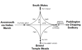
The Filton diamond area (Filton Junction, Patchway Junction, Stoke Gifford West Junction and Filton West Junction) is normally shown within the railway diagrammaticality as below. Except for the existing public passenger train maps (where of course, there are currently no passenger trains using the lines via Filton West Junction).

How best to show it on you map I don't know, but in future trains to/from Henbury may go via Filton Abbey Wood (using the Filton Chord FWC) missing out Bristol Parkway or go via Bristol Parkway (AFR) then reverse and then go via Filton Abbey Wood (FEC).

Filton diamond.png
 

Top