• Our booking engine at tickets.railforums.co.uk (powered by TrainSplit) helps support the running of the forum with every ticket purchase! Find out more and ask any questions/give us feedback in this thread!

CODE BLACK- "DO NOT TRAVEL" GWR Sunday 18/02/2024

zwk500

Veteran Member
Joined
20 Jan 2020
Messages
13,564
Location
Bristol
Or some long gradients to get over the top, or at least high enough, which could be shorter these days with electric traction rather than steam
Although of course any diversion today wouldn't be on the same alignment - partly because of the village on top and partly for constructability.

This relief shaded map does give a good idea of the problems faced by any attempt to raise the line: https://en-gb.topographic-map.com/map-1hm2/Bristol/?center=51.52049,-2.36687&zoom=12
 
Sponsor Post - registered members do not see these adverts; click here to register, or click here to log in
R

RailUK Forums

Bikeman78

Established Member
Joined
26 Apr 2018
Messages
4,619
A lot of the crossovers have had bits cut out and plain lined over the last year or so. Wootton Bassett, Bourton and Uffington are all in that state in at least one direction.
That's no good. Any plans to restore them?
 

Jimini

Established Member
Joined
8 Oct 2006
Messages
1,417
Location
London
Currently on a XC service from Birmingham to Reading (just leaving Oxford as I type), and the water levels in the fields along the Cherwell Valley have to be seen to be believed! Not seen anything like it around these parts before.
 

stuu

Established Member
Joined
2 Sep 2011
Messages
2,803
Or some long gradients to get over the top, or at least high enough, which could be shorter these days with electric traction rather than steam

Or a different route to avoid the hill? I'm not that familiar with the south Gloucestershire topography.
It's the southern end of the Cotswold escarpment, the route around it goes via Bath! The M4 is a few miles south and has a significant climb to the junction with the A46 which streetview shows very well how big a hill it is
 

rower40

Member
Joined
1 Jan 2008
Messages
337
There was some floodwater to the east of Cogload Junction yesterday but significantly more today. It's not unusual though for the area around Athelney to resemble Poole Harbour in winter.
A day that will live in infamy? Most of the US Navy Pacific fleet sunk or damaged?
Oh…
POOLE not Pearl.
Sorry; as you were….
 

TPO

Member
Joined
7 Jun 2018
Messages
358
I’m not aware of any system run solely of gravity pressure, except for distribution from tanks to houses in some cases. Most reservoirs will have a pump to increase water pressure on exit, then further booster pumps to counter friction loses.

Doing a basic head loss calculation, for a roughly best case scenario with the lowest friction pipes, you won’t even get a flow until your pipe is 0.5m in diameter. It's very unlikely you could get it to work without booster pumps.

The water from the Elan Valley reservoir complex to Birmingham is gravity fed. There's a height difference of 52 metres between the Foel Tower extraction point in the Elan (Carreg Ddu dam) to the Frankley reservoir near Birmigham. Gradient of 1:2300, flow of less than 2mph it takes up to 2 days to travel 73 miles. It has 2 x 42 inch diameter pipes and another 2 x 63 8nch pipes were added later.

TPO
 
Last edited:

Snow1964

Established Member
Joined
7 Oct 2019
Messages
6,461
Location
West Wiltshire
There is lot of rain forecast for SW overnight, and some of the rivers are still high, and floodplains already under water.

Could be some very wet (or flooded) areas tomorrow.
 

AlastairFraser

Established Member
Joined
12 Aug 2018
Messages
2,213
Straying into speculative territory here, but the proper solution would be to raise the line sufficiently to avoid flooding. Slightly less unlikely, how about a very long pipe so the excess water could be discharged into the Severn?
A bigger storm reservoir is another option. There's plenty of land to the south of the line to build one - it could even be equipped with floating solar panels and a small battery bank to operate pumps if you wanted.
 

WelshBluebird

Established Member
Joined
14 Jan 2010
Messages
4,924
Maybe a silly question but some of the lines on the line were lowered during electrification works to give enough clearance in tunnels and under some bridges for the wires. That hasn't had a knock on impact here has it?
 

Benjwri

Established Member
Joined
16 Jan 2022
Messages
1,908
Location
Bath
The water from the Elan Valley reservoir complex to Birmingham is gravity fed. There's a height difference of 52 metres between the Foel Tower extraction point in the Elan (Carreg Ddu dam) to the Frankley reservoir near Birmigham. Gradient of 1:2300, flow of less than 2mph it takes up to 2 days to travel 73 miles. It has 2 x 42 inch diameter pipes and another 2 x 63 8nch pipes were added later.
I believe this is a bit of aqueduct open channels? But yes I admit I was not aware of this system. What I will say though is that the low velocity, and therefore flow rate, which you mention here is the exact issue with a gravity fed system like this. Some very back of hand calculations give a flow rate of 0.32m3/s, which would be able to drain a catchment area (How much land drains onto the tunnel) of around 0.22km2, with the rainfall experienced on Sunday morning. I couldn't immediately find any figures for the tunnels catchment area, nor did I have time to work it out, but a brief look at a contour map suggests it is likely vastly greater than that area.
 

The exile

Established Member
Joined
31 Mar 2010
Messages
2,828
Location
Somerset
The water from the Elan Valley reservoir complex to Birmingham is gravity fed. There's a height difference of 52 metres between the Foel Tower extraction point in the Elan (Carreg Ddu dam) to the Frankley reservoir near Birmigham. Gradient of 1:2300, flow of less than 2mph it takes up to 2 days to travel 73 miles. It has 2 x 42 inch diameter pipes and another 2 x 63 8nch pipes were added later.

TPO
The Romans also managed it 2000 years ago - though of course, like with the Elan Valley, their concern was to ensure a constant supply of water rather than draining surges.
 

DelW

Established Member
Joined
15 Jan 2015
Messages
3,923
Although obviously far greater volumes of water in the reservoir, with a far greater elevation difference which is the key factor. Open channel flow is a bit of a different matter compared to the proposed pipe flow.
The Loch Katrine aqueducts are almost entirely pipes which have been landscaped over.
 

Annetts key

Established Member
Joined
13 Feb 2021
Messages
2,660
Location
West is best
Maybe a silly question but some of the lines on the line were lowered during electrification works to give enough clearance in tunnels and under some bridges for the wires. That hasn't had a knock on impact here has it?
Box Tunnel had it track lowered. I don't know if any significant lowering of the track through Chipping Sodbury tunnel took place. But that does not change the situation for the track flooding outside the tunnel at the former site of Chipping Sodbury station. And between that point and the tunnel.
 

Falcon1200

Established Member
Joined
14 Jun 2021
Messages
3,721
Location
Neilston, East Renfrewshire
Currently on a XC service from Birmingham to Reading (just leaving Oxford as I type), and the water levels in the fields along the Cherwell Valley have to be seen to be believed! Not seen anything like it around these parts before.

I was in Oxford over the weekend and the rain on Saturday night was extremely heavy, so much so that on Sunday morning, walking to the shops, I twice had to divert onto sodden grass as the pavement was completely flooded. And, later on Sunday, driving on the A40 towards Witney, there were again many flooded fields.

Also in Oxfordshire, this happened;


Fire crews have rescued a man after his car got stranded in floodwater under a bridge.
Crews responded to reports of a driver trapped in the Marsh Gibbon area, near Bicester, at about 06:30 GMT.
Firefighters from Bicester, Buckingham and Kidlington entered the water wearing drysuits and rescued the man from his car.

Sometimes, nature simply overwhelms what humans can reasonably achieve.
 

Snow1964

Established Member
Joined
7 Oct 2019
Messages
6,461
Location
West Wiltshire
There is currently flooding between Exeter and Plymouth

Unrelated is new line closure due to overhead line damage repairs Bristol-Newport from 22:00
 
Last edited:

Mag_seven

Forum Staff
Staff Member
Global Moderator
Joined
1 Sep 2014
Messages
10,066
Location
here to eternity
More flooding in the area again this evening, both Swindon - Chippenham and Swindon - Bristol Parkway routes affected.


Due to flooding between Swindon and Bristol Parkway the line towards Bristol Parkway is blocked.
Train services running through these stations will be cancelled, delayed or diverted. Disruption is expected until 18:15 22/02.

Due to flooding between Swindon and Bristol Temple Meads fewer trains are able to run on all lines.
Train services running through these stations will be cancelled or running non stop. Chippenham and Bath Spa will not be served. Disruption is expected until 17:30 22/02.
 

Snow1964

Established Member
Joined
7 Oct 2019
Messages
6,461
Location
West Wiltshire
More flooding in the area again this evening, both Swindon - Chippenham and Swindon - Bristol Parkway routes affected.

The Great Somerford rain gauge is showing 27.048mm in last 24 hours, just over an inch, not exceptional


VP185

Member
Joined
13 Feb 2010
Messages
345
Box Tunnel had it track lowered. I don't know if any significant lowering of the track through Chipping Sodbury tunnel took place. But that does not change the situation for the track flooding outside the tunnel at the former site of Chipping Sodbury station. And between that point and the tunnel.

The track was lowered in the Dauntsey area to allow for electrification under a bridge. I don’t if that’s the area that is now flooding but it wouldn’t surprise me.
 

Bald Rick

Veteran Member
Joined
28 Sep 2010
Messages
29,269
The Great Somerford rain gauge is showing 27.048mm in last 24 hours, just over an inch, not exceptional


Not exceptional, but still about a week‘s worth in 24 hours, and therefore significant.

The flooding is not just a function of how much it has rained in the immediate past, but also how high the ground water is and the Soil Moisture deficit.

Where I am (Hertfordshire), the SMD is 0, and the ground water is very high, so all the rain runs off immediately and has no where to go except the watercourses. And when they are full, it floods. I’ve been here over 20 years and never seen so much floodwater.

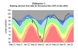
It’s a similar situation at Chipping Sodbury. The groundwater levels at Didmarton (a few miles from Chipping Sodbury) at the end of January were ‘off the chart’ in the ‘exceptionally high’ range, and there’s been a lot more rain since. With 0 SMD, that week’s worth of rain is going straight into the watercourses, and when they are full - which they will be, and quickly - straight into the nearest low lying ground.
 

Attachments

  • D00CD258-6218-4E6A-8F55-F4CABC45CD08.jpeg
    D00CD258-6218-4E6A-8F55-F4CABC45CD08.jpeg
    212.2 KB · Views: 19

Peter Fox

Member
Joined
1 Mar 2018
Messages
60
There is currently flooding between Exeter and Plymouth
In the olden days we used to have 'bands' of rain. Now we have 'Blankets'. The trouble is EVERY bloody time it rains the line between Totnes and Plymouth is shut for checking the bridges haven't been washed away or sealions haven't eaten the sleepers. This time for over Wednesday pm and Thurs am. If you're in charge of the infrastructure to run trains then you have to accept the responsibility of maintaining it.
 

Mcr Warrior

Veteran Member
Joined
8 Jan 2009
Messages
12,083
In the olden days we used to have 'bands' of rain. Now we have 'Blankets'. The trouble is EVERY bloody time it rains the line between Totnes and Plymouth is shut for checking the bridges haven't been washed away or sealions haven't eaten the sleepers.
Don't think that even Reggie Perrin ever came up with that one! ;)
 

Falcon1200

Established Member
Joined
14 Jun 2021
Messages
3,721
Location
Neilston, East Renfrewshire
If you're in charge of the infrastructure to run trains then you have to accept the responsibility of maintaining it.

And that is what Network Rail is doing by ensuring the railway remains safe during extreme weather; The alternative is the possibility of another Glanrhyd bridge or Lamington viaduct.
 

The exile

Established Member
Joined
31 Mar 2010
Messages
2,828
Location
Somerset
And that is what Network Rail is doing by ensuring the railway remains safe during extreme weather; The alternative is the possibility of another Glanrhyd bridge or Lamington viaduct.
There’s two words unfortunately missing from that statement: “and operational”. There needs, for example, to be equipment that means there’s no need to wait for daylight to do an inspection.
 

Benjwri

Established Member
Joined
16 Jan 2022
Messages
1,908
Location
Bath
There’s two words unfortunately missing from that statement: “and operational”. There needs, for example, to be equipment that means there’s no need to wait for daylight to do an inspection.
I don’t think anywhere has equipment like that. Even a camera cannot capture every angle, and can often be covered in dirt so have worsened quality. You can put as many sensors as you want but they wouldn’t detect a crack or similar.
 

zwk500

Veteran Member
Joined
20 Jan 2020
Messages
13,564
Location
Bristol
There’s two words unfortunately missing from that statement: “and operational”. There needs, for example, to be equipment that means there’s no need to wait for daylight to do an inspection.
Are you talking about a torch, or something slightly more hi-tech?
 

fandroid

Established Member
Joined
9 Nov 2014
Messages
1,761
Location
Hampshire
We had a wet summer in 2023. There was no buffer to absorb the normal rain expected in the Autumn, let alone the rain we've had through the winter.
 

al78

Established Member
Joined
7 Jan 2013
Messages
2,436
We had a wet summer in 2023. There was no buffer to absorb the normal rain expected in the Autumn, let alone the rain we've had through the winter.
Not just the summer. Last year was the fourth wettest on record where records go back around 250 years and that is despite a very dry February, a dry late May - late June and an exceptional September heatwave. 2024 has started on the same theme, with the exception of a brief cold settled spell in January, a southerly displaced jet stream steering low pressure systems across the UK. 20-30 mm of rain in a day doesn't sound a lot but when the weather has been changeable or unsettled for months with almost no prolonged dry spells, there comes a point where the ground and rivers cannot take any more and regions, or even much of the country, is primed for flooding.
 

Top