AndrewRL
Member

195115 did a full Lancaster to Carlisle run on 8th Feb, a picture of it at Lancaster was posted by @Guard_Amos on X. It was a sub for a failed 156, I tracked it on RTT and it made it all the way.I am unaware of them ever travelling north of Millom on that route (other than trivially just north of the station to "run around" to the down platform for Millom terminators).
It was swapped at Barrow. There is no route clearance or PTI assessment beyond Millom (currently).195115 did a full Lancaster to Carlisle run on 8th Feb, a picture of it at Lancaster was posted by @Guard_Amos on X. It was a sub for a failed 156, I tracked it on RTT and it made it all the way.
I'm not convinced what you are seeing is oil. To me it looks like the crud that accumulates on the top of many concrete sleepers. Compare to the tops of the sleepers on the adjacent line.Rather heavy oil contamination on the sleepers to the left of the picture....which would suggest spillage from a damaged engine sump or transmission.
Surely they can rustle up suitable route conductors and take them the long way round the Cumbrian coast?There’s probably a saving of 2-4 units not running to Barrow, I’d imagine.
But still a pretty big hole.
not if they're not cleared for the route.......you stand a risk of them not fitting in the tunnels. Do you want to smash another one?Surely they can rustle up suitable route conductors and take them the long way round the Cumbrian coast?
As has already been stated, they are not cleared for the route.Surely they can rustle up suitable route conductors and take them the long way round the Cumbrian coast?
I imagine there's more than a few stretches of lines built along similar estuaries and coastlines where culverts realistically need permanently widening out into proper bridges to allow sufficient flow. I doubt that'll happen because of money though...Shows how undermined both tracks have become. The Royal Engineers could probably set up a Bailey bridge if there were a war on.
The more I look at that photo, the more that I am convinced that there was some kind of structure there. If the top of the embankment was just ballast with dirt/soil/spoil under it, I would not expect to see straight lines. But there is a horizontal line under the adjacent line. And under the right hand sleeper that still has ballast under it.Shows how undermined both tracks have become. The Royal Engineers could probably set up a Bailey bridge if there were a war on.
A proper bridge that would allow the sea to flood the low lying land behind the railway? Surely it needs some sort of a flap valve, and that’s presumably where it would silt up and get blocked. Or a proper permanent pumping system, which the discharge hoses running under the ballast suggest has been attempted already for some reason.I imagine there's more than a few stretches of lines built along similar estuaries and coastlines where culverts realistically need permanently widening out into proper bridges to allow sufficient flow. I doubt that'll happen because of money though...
Shows how undermined both tracks have become. The Royal Engineers could probably set up a Bailey bridge if there were a war on.
Essentially, yes. I won't lose any sleep over a golf course, although I will be far more sympathetic to farmers who lose land and therefore valuable income. Equally it must be recognised that fighting nature will always be a losing battle and the value of doing so in an increasingly environmentally sensitive world is going to need to be considered very carefully. Picking battles involves sacrificing some areas, and there are ways to adapt to a salt marsh environment rather than just building the type of land we prefer.A proper bridge that would allow the sea to flood the low lying land behind the railway? Surely it needs some sort of a flap valve, and that’s presumably where it would silt up and get blocked. Or a proper permanent pumping system, which the discharge hoses running under the ballast suggest has been attempted already for some reason.
No-one commissions a report from what used to be Hydraulics Research Wallingford without good reason (Post#99)The Winster goes nowhere near Arnside, which is on the other side of the Kent estuary.
Difficult to see how it can be solved without dropping the deliberately raised water table in the Foulshaw and Meathop Mosses, which are both nature reserves. There has been a deliberate attempt to return them to marshland over the last 15 or so years. If you add that to continued complaints over years about the inability of the authorities to make the Winster valley drainage work and you've got a lot of water with nowhere to go.
Just found this 2018 document (8 page pdf) which overviews the drainage in the area, the flood risk, and the history.
It explains how the Winster and associated waterways are protected and linked, and how they relate to the railway embankment
(Unfortunately it won't let me copy the text so I can't post a preview)
Whilst, with <zwk500>, not lamenting the loss of a golf course, it is (was) of course a business and much affected by what appear to be changes to the flood environment 'caused' by others, not doubt seeking the 'national good'. In my book, as with those affected injuriously by eg HS2, or a new road project, they should be reasonably compensated. (And similarly, IMHO, those who benefit from changes should pay what was called IIRC in the 1947 Town & Country Planning Act 'betterment'). Some coastal areas are already being sacrificed to 'managed retreat', why not here? Perhaps 'the railway' should be 'compensated' rather than sacrificed. Is there anything to be learned from 'fighting nature' at Dawlish?Essentially, yes. I won't lose any sleep over a golf course, although I will be far more sympathetic to farmers who lose land and therefore valuable income. Equally it must be recognised that fighting nature will always be a losing battle and the value of doing so in an increasingly environmentally sensitive world is going to need to be considered very carefully. Picking battles involves sacrificing some areas, and there are ways to adapt to a salt marsh environment rather than just building the type of land we prefer.
Doesn't need to be a proper bridge, just culverts under the track. Luckily these things are already available (Linking a catalogue), there are other makers but the pictures show what they look like.A proper bridge that would allow the sea to flood the low lying land behind the railway? Surely it needs some sort of a flap valve, and that’s presumably where it would silt up and get blocked. Or a proper permanent pumping system, which the discharge hoses running under the ballast suggest has been attempted already for some reason.
It depends where you drag it in Barrow. If it’s the docks, getting it out of town wouldn’t be too bad, but the carriage sidings are in a reasonably narrow residential area, and could be a bit more tricky.I was told it was to test for bomb proofing. That's why it had to go to the Eskmeals complex.
They get things to the BAE Shipyard so why is it likely to be such a problem ?
Carnforth is on the wrong side of the hole
And actually it's not that easy to get stuff out through the town - when Dr Beet's German and French locos were taken out 30-odd years ago they had to do it by running the wrong way up (one way street) Haws Hill, then down the A6 into Lancaster. And when they got to M6 J34 the turn onto the slip road proved too tight and the signs and bollards got demolished.....
Taking the normal routes through Carnforth to the M6 aren't options: either the turn onto the northbound A6 is too tight, or if you use the Over Kellet road you're faced with a weak narrow canal bridge with sharp turns at each end.
I am unaware of them ever travelling north of Millom on that route (other than trivially just north of the station to "run around" to the down platform for Millom terminators).
I’ve definitely seen a photo of one at Workington, but I can’t find it currently. There is a photo of 195010 and 195018 at Parton, running 5C12 Maryport - Barrow, on June 16th 2020 on the Cumbrian Coast Railway Facebook group.I believe one has made it to at least Workington before now, possibly even Maryport? As far as I'm aware it's Bullgill near Aspatria that's the problem? Probably more issues further up too.
I walked up to the football ground at Barrow the other week, past that entrance to the Carriage Sidings. The other day i was trying to visualise how it would get out of the residential area and I agree its tricky.It depends where you drag it in Barrow. If it’s the docks, getting it out of town wouldn’t be too bad, but the carriage sidings are in a reasonably narrow residential area, and could be a bit more tricky.
Things going to BaE tend to be a bit smaller than a 195, and anything bigger tends to go out under the sea.
It is currently, but it depends whether you’ve got time to wait on getting those units off for repair - drag them out of the way while the hole is fixed, and then you could drag them back to wherever you wanted. I’ve had a look at the turn on street view, and I’m fairly sure most modern trombone trailers would be able to be got round with the steering capability they have - and i certainly know a few lads who would be up for the challenge!
Do they need to use the WCML?Is it down to cost of dragging the units back down the (by then mended) line and along the WCML vs the planning and execution of them coming out by road or is there something else to think of?
I believe part of the road there occupies the former railway from Plumpton Junction to Haverthwaite on its way to Lakeside.Not quite sure which bit you mean by Greenodd Bends. Admittedly some of the roads in the area, including parts of the A590, are very dodgy, but Greenodd village was bypassed in 1983 for traffic going from Barrow to any of Lancaster, Carnforth, Kendal, or the M6 for Carlisle.
Probably due to some other cause. As each part of the train passed this point it would be undamaged. Damage would be caused after the train was derailed, and hit the track bed, which at 56mph would be some way further along.Rather heavy oil contamination on the sleepers to the left of the picture....which would suggest spillage from a damaged engine sump or transmission.
As an interesting aside, the "six foot" at Bullgill is actually 4' 8". As a junior perway engineer in the mid 1960s I had cause to measure it.The restriction at Bullgill bridge is because the lines have been squeezed under the bridge causing a narrower “six foot”.
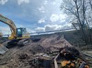
I assume we are looking into a void where the side has been dug away, creating a sort of cave mouth. It looks just as in the contemporary description of the construction (post #68) - a pile of estuary sand/silt, capped by a layer of clay, with quarry waste ("rids") and then ballast on top.Picture taken from Meathop road (Up side) 31/3/24. Excavation looks substantially complete. Remains of the pipes are clearly visilble going through the wall on the seaward (Down) side. There is a temporary pump and pipe system in operation.