Greetlander
Member
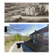
Been on Google Earth - I almost want to agree with you - prominent houses closest on Victoria Park Road??Buxton?
Been on Google Earth - I almost want to agree with you - prominent houses closest on Victoria Park Road??Buxton?
It's only speculation - but possibly yes, looking down from the Fairfield district which rises fairly steeply on the east side of the town. I can't pin it down though.Been on Google Earth - I almost want to agree with you - prominent houses closest on Victoria Park Road??

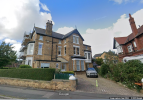
Sorry, but I can’t see a match between the houses. Am I missing something?Without saying where I've found this matching road topography, just to avoid any wild goose chases...
...and yes, there is a viaduct through the trees although I don't think it is because it looks a lot closer than in the old photograph... but the similarities, including the height and shape of the hills behind, are striking.
Thoughts?
View attachment 173905
The houses are very likely to have been redeveloped since 1900...Sorry, but I can’t see a match between the houses. Am I missing something?
I wouldn't say *very* likely. More like "could have been redeveloped".The houses are very likely to have been redeveloped since 1900...
The road certainly could have been redeveloped, although my gut instinct is that some or all of the houses will be still extant. The original houses were no doubt quite expensive in their day, so unless something drastic had happened (such as war damage or the whole town becoming so economically distressed they became derelict), I would assume they would only be replaced by something that would make more money for the developer after paying a still hefty purchase price. In recent years this might include low-rise, relatively upmarket apartments, perhaps? Maybe at one time a large detached home might also have been a replacement, but the sites look a bit small for that. Other readers might have further suggestions?The houses are very likely to have been redeveloped since 1900...
I'm searching for the road layout with a viaduct behind.
The road layout is a lot less likely to change than the housing stock.
I would suggest the chances that large Victorian villas were redeveloped into stone-built terraces are infinitesimally smallThe houses are very likely to have been redeveloped since 1900...
I couldn't make the Buxton suggestion make sense, even with old maps from NLSAny advance on Buxton?
I also said that I didn't think the location I found was the one we are looking for ( which is why I didn't name it ); my context was that the distinctive shape of the road is likely to be a better means of finding the location than looking at the houses.I would suggest the chances that large Victorian villas were redeveloped into stone-built terraces are infinitesimally small
Those "small white buildings" could be racks of blankets or linen drying?I find the row of very small white buildings extending off to the left of the photo quite curious, just because they look so small compared to the (new?) houses to the right along the same road or lane. Given that they're painted white I assume they're cottages, but they look like individual single-storey buildings rather than a continuous terrace, which is surprising.
From the tree in the foreground and the other trees/bushes visible it looks likely that the view is to the NW, with the prevailing wind coming from the left of the view.
It "feels" to me like North of England rather than Scotland, but I wouldn't want to put money on it...
The absence of leaves on the trees suggests the photo was taken in winter. So presumably it's cold. In which case, though it may be a trick of the light, it seems strange that so many fires are apparently lit in the cottages, but so few in the villas. Are the well-heeled not at home?I find the row of very small white buildings extending off to the left of the photo quite curious, just because they look so small compared to the (new?) houses to the right along the same road or lane. Given that they're painted white I assume they're cottages, but they look like individual single-storey buildings rather than a continuous terrace, which is surprising.
From the tree in the foreground and the other trees/bushes visible it looks likely that the view is to the NW, with the prevailing wind coming from the left of the view.
It "feels" to me like North of England rather than Scotland, but I wouldn't want to put money on it...
Perhaps the viaduct is no longer exant? Plenty of closed routes.There can't be all that many hairpins in the country with a viaduct behind them, surely?
That's a strong possibility, but should be possible to establish where viaducts have been removed and then compare with the road layouts - then look for older photos of whatever area?Perhaps the viaduct is no longer exant? Plenty of closed routes.
Excellent work - would never have thought of looking that far across!!An update, this has now been solved as a view of Scarborough taken from Oliver’s Mount, with Oriel Crescent being the street in the centre of the photo. Thanks again for all the replies.

Valley Road, I think this turned out to be? Not at all clear in the original, might have been a much smaller road.I wonder if the thick pillars in the viaduct are designed to enable a skew arch to be formed to enable the railway to cross something else at an angle - a canal perhaps.
I was thinking seaside chalets. just seen it's Scarborough...I find the row of very small white buildings extending off to the left of the photo quite curious, just because they look so small compared to the (new?) houses to the right along the same road or lane. Given that they're painted white I assume they're cottages, but they look like individual single-storey buildings rather than a continuous terrace, which is surprising.
From the tree in the foreground and the other trees/bushes visible it looks likely that the view is to the NW, with the prevailing wind coming from the left of the view.
It "feels" to me like North of England rather than Scotland, but I wouldn't want to put money on it...
It would be very interesting to know what those actually were. I think I'm right in saying that is where the modern housing on the southern end of Weaponness Valley Road now stands.I was thinking seaside chalets. just seen it's Scarborough...
