• Our booking engine at tickets.railforums.co.uk (powered by TrainSplit) helps support the running of the forum with every ticket purchase! Find out more and ask any questions/give us feedback in this thread!

Disused railways and what remains

Status
Not open for further replies.

33011

Member
Joined
8 Sep 2008
Messages
297
I am into disused railways and what I find fascinating is what remains ie TP huts, bridges, tunnels, platforms etc etc. My main love is the Somerset and Dorset and there is quite a bit remains including Templecombe engine shed now in Industrial use. What disused railways have you walked and what interesting things have you found that still remain that surprised you years after closure or even disused lines you would recommend walking?
 
Sponsor Post - registered members do not see these adverts; click here to register, or click here to log in
R

RailUK Forums

Western 52

Member
Joined
19 Jun 2020
Messages
1,125
Location
Burry Port
In Swansea. the route of the former Mumbles Railway is a popular 5 mile long sea front path. Great views of the bay, and its a flat and easy walk, but watch out for the fast cycles! Some remnants of the former railway can be seen, such as the former station building at Oystermouth and the Blackpill station / electric substation (now used as a restaurant). There are also a few of the former electrification poles to be seen, but very few now, and some at the Mumbles end have recently been reduced in height.

There is also a paved footpath which leads up the Clyne Valley from near Blackpill along the former LMS route up as far as Gowerton. Again an easy walk, but less scenic as its tree lined all the way. If you know where to look, there's a surviving concrete milepost. The platforms at Killay station are still partly visible.
 

GusB

Established Member
Associate Staff
Buses & Coaches
Joined
9 Jul 2016
Messages
6,616
Location
Elginshire
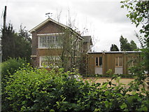
I live by the former Highland Railway branch which went between Alves Junction and Hopeman. There is very little left in terms of buildings; the station building at Hopeman still exists, as does the one at Alves Junction (both are private residences). The Burghead station building was still there when I was younger, but unfortunately it succumbed to fire a few years ago and was destroyed. The Burghead site has since been cleared, the road overbridge demolished and the sidings which served the maltings have been lifted; all the grain traffic now goes by road.

Hopeman still has its platforms, one of which I assume was for goods, and the site is now the West Beach Caravan Park. Had it not been for the caravans, I suspect the land would have been developed for housing a long time ago.

As far as I'm aware, apart from the road bridge in Burghead, all the original bridges are still intact. The alignment between Burghead and Hopeman is now part of the Moray Coastal Trail and is tarmacked between Burghead and Cummingston. There are a couple of rusty remnants of gates that were probably foot crossings along the way. In one spot, part of the embankment has been eroded away, but the path has been diverted around this.

The connection to the Aberdeen - Inverness line was severed when they did the A2I improvements a few years ago, but the track still exists between Alves and Burghead; it was very overgrown the last time I looked. I'm fairly certain the sidings at Roseisle Maltings are still there, and there used to be a halt at Coltfield where there's both an overbridge and a level crossing.
 

JBuchananGB

Member
Joined
30 Jan 2017
Messages
986
Location
Southport
There are books galore and multiplicities of web sites dedicated to all aspects of residual manifestations of long closed railways. I have walked along a few disused trackbeds in various places, the Flitch Way near Dunmow between Braintree and Bishop's Stortford, where one of the stations is now the visitor centre for the Flitch Way., part of the line near Stow Maries which used to go from Southminster to Maldon. A length of the Wirral Way from Hooton to Hadlow Road, including the beautifully preserved Hadlow Road Station. A bit of line in Staffordshire between Gnosall and Stafford which is a long distance footpath/cycle way. I've seen a bit of the Cuckoo Way in Heathfield, which I remember travelling by train before it closed. Every time I drive a couple of miles from home across completely flat fields I have to ascend a blind summit to go over a railway bridge under which a train called Altcar 'Bob' has not travelled for over 80 years. One could go on for ever.
 
Last edited:

steamybrian

Established Member
Joined
26 Nov 2010
Messages
1,748
Location
Kent
I have walked many miles of abandoned disused lines and it is interesting to spot any hidden remains such as mileposts, gradient posts, signals as well as odd sections of track. Living in the South East I have walked Cuckoo Trail, Three Bridges- Groombridge, Christs Hospital - Guildford (Peasmarsh), Sandling- Hythe, as much as the Kent& East Sussex Railway as possible (before part of the line reopened) , Canterbury- Whitstable, Ramsgate Harbour- Margate Sands, Uckfield to Lewes, Crystal Palace High Level branch, Finsbury Park- Alexandra Palace via Highgate plus sections of other lines. My favourite I think was in Wales between Morfa Mawddach (Barmouth Jn) to Dolgellau alongside the Afon Mawddach.
 

EbbwJunction1

Established Member
Joined
25 Mar 2010
Messages
1,565
In Swansea. the route of the former Mumbles Railway is a popular 5 mile long sea front path. Great views of the bay, and its a flat and easy walk, but watch out for the fast cycles! Some remnants of the former railway can be seen, such as the former station building at Oystermouth and the Blackpill station / electric substation (now used as a restaurant). There are also a few of the former electrification poles to be seen, but very few now, and some at the Mumbles end have recently been reduced in height.

There is also a paved footpath which leads up the Clyne Valley from near Blackpill along the former LMS route up as far as Gowerton. Again an easy walk, but less scenic as its tree lined all the way. If you know where to look, there's a surviving concrete milepost. The platforms at Killay station are still partly visible.
There is also a former footbridge which crossed what is now the main road between Swansea and Mumbles near to St Helen's. It was removed many years ago and spent a long time in the car park at the far end of the ground, before being refurbished and moved onto the route of the railway referred to above. It isn't actually a bridge any more, as it just rests on the ground, but you can walk "across" it. The pillars of the original bridge are still in situ at their original place.
 

PeterC

Established Member
Joined
29 Sep 2014
Messages
4,087
There are several walks in the Abergavenny / Blaenavon area ranging from tramroads closed in the 19th century to lines closed as late as 1980.

Llanfoist Wharf on the Mon and Brecon Canal is nice but you might want to arrange to be picked up if you walk the incline to the main line of Hills Tramroad.
 

32475

Member
Joined
2 Nov 2019
Messages
744
Location
Sandwich
A favourite subject! Much of my youth in Sussex in the 1970's was spent exploring old lines which had closed not so long ago. Much overgrown they were the most wonderful and evocative places to explore and walking through an old tunnel or cutting, the senses were on high alert for the sound of a ghost train in the distance. Discarded sleepers, chairs, the odd length of rail forgotten by demolition contractors were fairly common place and coming across an abandoned station, signal box or crossing gates was just heaven!
If you're not familiar with it, the very best website to research is disused-stations.org.uk which has a wonderful wealth of information and photos of stations and infrastructure before and after closure including recent photos of what remains today. I can't recommend it highly enough.
 

Journeyman

Established Member
Joined
16 Apr 2014
Messages
6,295
If you're not familiar with it, the very best website to research is disused-stations.org.uk which has a wonderful wealth of information and photos of stations and infrastructure before and after closure including recent photos of what remains today. I can't recommend it highly enough.

Agreed, it's an internet rabbit hole I frequently disappear into for ages. :) It's hugely comprehensive and gets regular updates. Many of the photos on the site were shot by Nick Catford, who is hugely knowledgeable on abandoned places in the UK - he's a big authority on Cold War bunkers as well.

Sadly a lot of abandoned rail infrastructure has vanished without a trace, but there's still plenty of good stuff left. You often have to go a bit out of the way to find it, though.
 

33011

Member
Joined
8 Sep 2008
Messages
297
I have the Somerset and Dorset then and now book by Mac Hawkins and also his LSWR west country then and now book. The lengths he went to capture a near as possible shots in the same location are amazing. One shot of a train at Evercreech Junction for example was taken from the footbridge Macs shot was taken on top of a crate lifted up by a forklift truck to roughly the same height and position as the long removed footbridge. I think he has done a Great Central version as well
 

UP13

Member
Joined
27 Jul 2018
Messages
373
Not an abandoned line, but my daughter's absolute favourite place to explore is a set of abandoned sidings just north of Twickenham Junction. They were uncovered when a new footpath was opened recently in what was an overgrown strip of land. She refers to them as the lost buffers and never bores or them.

In terms of actual walks, we did Bideford to Instow last year on holiday. Lovely views, Bideford station is wonderfully preserved, old gradient signs along the way plus the old platform and signal at Instow. Lovely pub lunch after a leisurely two hour walk.
 

Iskra

Established Member
Joined
11 Jun 2014
Messages
7,954
Location
West Riding
Is there much left to see of the Dumfries to Stranraer line?
Big Water of Fleet viaduct would be the main attraction for me. It’s on my agenda for next year to visit.

I always find it curious how the platforms at Woodhead are still in situ and in such good condition after so many years.
 

Watford West

Member
Joined
20 Jul 2020
Messages
29
Location
Watford
I took my then girlfriend to look at the old Great Central line once when we were first together (it almost ended that day as well) We found Catesby tunnel, and walked into it. I can't remember if it was blocked off, with just a small door to get in? Anyway we got in and started walking through it. We had no torches, and my girlfriend was not at all happy. We had not gone too far, when suddenly she fell down a hole! Luckily for her (and me) the hole wasn't too deep, and she had not hurt herself too much, but understandably that was the end of the tunnel walking and we turn around and left!
One of the walks that I have done on a disused line is the one that runs behind Weymouth and goes out towards Portland and along the causeway. There is much evidence left of the former railway, with a tunnel and platforms although at least one bridge has been removed which entails dropping down from the embankment crossing the road and climbing back up again. Incidentally I have seen a photograph of this section of embankment taken during WW2 with an Anti-Aircraft gun set up along side the railway line. Obviously all ports were targets during the war and this relatively 'high' point would serve as a gun emplacement
 

Eyersey468

Established Member
Joined
14 Sep 2018
Messages
2,167
I live not far from the old York to Beverley line. The trackbed is intact from Market Weighton to Beverley and is known as the Hudson Way. At Kiplingcotes about a couple of miles from Market Weighton the old station house and platforms still stand along with an old engine shed, now a furniture shop, and the signal box, about the only box on the route to survive. Given it is in the middle of nowhere on the face of it it's a strange place to build a station, but the reason is the then Lord Hotham insisted on a station being built for him to use otherwise he wouldn't let the line cross his land.

Other lines near me where at least part of the route can be walked are the old Hull to Hornsea and Hull to Withernsea lines, a mile outside Patrington there was a station at Winestead, which I have never understood why it was built given the short distance to Patrington.
 
Last edited:

John Webb

Established Member
Joined
5 Jun 2010
Messages
3,073
Location
St Albans
......Other lines near me where at least part of the route can be walked are the old Hull to Hornsea and Hull to Withernsea lines, a mile outside Patrington there was a station at Winestead, which I have never understood why it was built given the short distance to Patrington.
A look at Disused Stations: Winestead may be of help? It actually closed to passengers in 1904 because of the proximity of Patrington. The Disused Stations website is an excellent source, but covers a bit under half of the near 5,000 stations that have been closed over the years.

Another source of interesting photos, past and present, of railways and their remains can be found at https://www.geograph.org.uk/ which is based on the 1km squares of the Ordnance Survey's National Grid scheme. Post #8 above includes a link to one of their photos. Here as an example are two photos from the former Warthill station on the York-Market Weighton-Beverley line. (Click on the photos to go to the larger originals):
From 2009:
Signal Box at the former Warthill Station near Stockton on the Forest

© Copyright John Webb and licensed for reuse under this Creative Commons Licence.
I mention in my comments on this photo that this former signalbox underwent further conversion soon afterwards. That work is seen in this photo from 2010:
Warthill railway station (site), Yorkshire

© Copyright Nigel Thompson and licensed for reuse under this Creative Commons Licence.
 

Eyersey468

Established Member
Joined
14 Sep 2018
Messages
2,167
A look at Disused Stations: Winestead may be of help? It actually closed to passengers in 1904 because of the proximity of Patrington. The Disused Stations website is an excellent source, but covers a bit under half of the near 5,000 stations that have been closed over the years.

Another source of interesting photos, past and present, of railways and their remains can be found at https://www.geograph.org.uk/ which is based on the 1km squares of the Ordnance Survey's National Grid scheme. Post #8 above includes a link to one of their photos. Here as an example are two photos from the former Warthill station on the York-Market Weighton-Beverley line. (Click on the photos to go to the larger originals):
From 2009:
Signal Box at the former Warthill Station near Stockton on the Forest

© Copyright John Webb and licensed for reuse under this Creative Commons Licence.
I mention in my comments on this photo that this former signalbox underwent further conversion soon afterwards. That work is seen in this photo from 2010:
Warthill railway station (site), Yorkshire

© Copyright Nigel Thompson and licensed for reuse under this Creative Commons Licence.
Thank you. It's interesting you should mention Warthill as that was the first level crossing on BR to be converted to barriers.
 

DerekC

Established Member
Joined
26 Oct 2015
Messages
2,119
Location
Hampshire (nearly a Hog)
My local disused line is the Meon Valley (Alton Butts Junction to Fareham Knowle Junction) and I have walked most of the accessible bits. The station platforms at West Meon are still extant, complete with the "dip" two thirds of the way along, put in when the LSWR realised that they were never going to run 10-coach trains on the line and a barrow crossing nearer the station buildings would be convenient. The station buildings are long gone, reputedly because Hampshire County Council was short of hardcore for a car park sometime in the 60s. By contrast the station buildings at Droxford and Privett are rather posh houses! The section from West Meon southwards as far as Wickham is a cycling and walking trail owned by Hampshire CC. The brick bridges are intact, together with steel underbridges at Droxford station and Wickham. The LSWR precast concrete fence posts are still there in many places and there is a loading gauge at Mislingford Siding, but not many other reminders that you are walking what was a railway.
 

Pinza-C55

Member
Joined
23 May 2015
Messages
1,035
Thank you. It's interesting you should mention Warthill as that was the first level crossing on BR to be converted to barriers.

Another interesting feature of that line is that it was going to be an early installation of CTC (Centralised Traffic Control) which would have seen it resignalled with colour lights and partly singled , all controlled from York power box. Apparently a lot of the equipment was delivered but then Beeching decided to close it instead.
 

Mogz

Member
Joined
20 May 2019
Messages
445
West Kirby - Hooton:

is officially a walking track known as the Wirral Way. There are plenty of overbridges still in situ, station platforms are still there at Thurstaston and Hadlow Road Station is intact and restored (including a very short length of track). The derelict platform at Hooton can still be found. Someone once told me that a signal post was still in situ somewhere but I’ve never found it.

Banbury- Cheltenham:

I’ve walked short stretches of this between Adderbury and Bloxham. Bridges are in situ and the occasional
bit of fence but little else. There is an old derelict freight wagon in a field near Bloxham immediately adjacent to the line. I wonder if that has been there since the line closed or was brought there afterwards.

Great Central Main Line between Helmdon Station and Sulgrave:

A bit of a goldmine. Helmdon Station island platform in situ but overgrown. Derelict buildings adjacent to freight yard. Viaduct still in good condition to the north, platelayer’s hut in situ after that.
Occasional bit of signal cable here and there.

Banbury (Merton Street) - Buckingham:

I’ve walked a short stretch from Merton Street to the motorway. Found a single relic- a cable anchor of some sort.
 

33011

Member
Joined
8 Sep 2008
Messages
297
My local disused line is the Meon Valley (Alton Butts Junction to Fareham Knowle Junction) and I have walked most of the accessible bits. The station platforms at West Meon are still extant, complete with the "dip" two thirds of the way along, put in when the LSWR realised that they were never going to run 10-coach trains on the line and a barrow crossing nearer the station buildings would be convenient. The station buildings are long gone, reputedly because Hampshire County Council was short of hardcore for a car park sometime in the 60s. By contrast the station buildings at Droxford and Privett are rather posh houses! The section from West Meon southwards as far as Wickham is a cycling and walking trail owned by Hampshire CC. The brick bridges are intact, together with steel underbridges at Droxford station and Wickham. The LSWR precast concrete fence posts are still there in many places and there is a loading gauge at Mislingford Siding, but not many other reminders that you are walking what was a railway.
The station building and parts of the platform at Tisted also remain. Does anyone know if the platform at Bentworth and Lasham on the old Basingstoke to Alton line still remain?
 
Last edited:

Jona26

Member
Joined
2 Jan 2013
Messages
273
Location
West Sussex
At least some of the BBC series Railway Walks with Julia Bradbury are on YouTube even though they aren't on the iPlayer at the moment.
 

John Webb

Established Member
Joined
5 Jun 2010
Messages
3,073
Location
St Albans

33011

Member
Joined
8 Sep 2008
Messages
297
I think the site was sold for housing in recent years so I don't know if it's still there.
 
Last edited:
Status
Not open for further replies.

Top