Dave_Cardboard
Member
- Joined
- 18 Oct 2017
- Messages
- 215
There's a few photos - including some aerial ones - searching Twitter for @networkraileus.
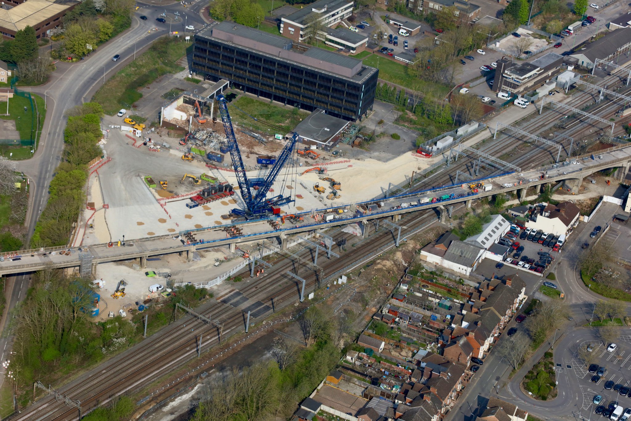
Bit touch and go I heard as to whether it would happenA busy Easter bank holiday weekend of works ahead on Bletchley Flyover. The Mercury House car park on Buckingham Road now has a 750T crane set up, to start the process of removing spans from the flyover. The smaller office block has been demolished and the middle sized office block is in the process of being demolished.
 twitter.com
Looks quite dated and not very big. The site must be worth a fortune right near the station, with EWR only making it more so.I've no idea what plans there are for the larger dark building.
Looks quite dated and not very big. The site must be worth a fortune right near the station, with EWR only making it more so.
Anyone got a quick link to where the high level platforms are going relative to the junction for MK please?
There’s an artists impression in this post:[…]
Anyone got a quick link to where the high level platforms are going relative to the junction for MK please?
I think the existing high level junction position is tweaked a little, but is basically within a few yards of its present location.The platforms won't be over the WCML - they'll be off to the side, just before the junction...
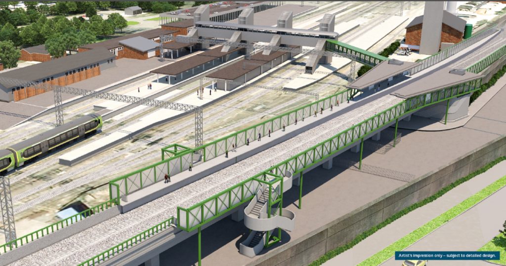
Thanks, it’s going to be pretty tight!There’s an artists impression in this post:
I think the existing high level junction position is tweaked a little, but is basically within a few yards of its present location.
The entire package of TWA drawings was linked at one stage back in 2018, but they’re proving elusive a5 the moment...
I'm curious as to why those buildings are coming down too...just coincidence? They don't llok to be anywhere near the worksite nor impinging any rail alignments. Hopefully it's not for a massive new development right up against the tracks. Would be nice to preserve an alignment on the west of the station for future enlargements, though I can't really see that happening any time soon.
It’s looking very like a useful coincidence to me. The streetview images suggest the offices are some sort of annex to the main block on Buckingham Rd, and the greenery up the buildings indicates they’ve been empty for a long time, but it’s still very unlikely they’d have been compulsory purchased for use as a worksite under the TWA. Especially as the TWA didn’t actually allow for flyover demolition and rebuild, it was originally an overhaul and waterproofing.I'm curious as to why those buildings are coming down too...just coincidence? They don't look to be anywhere near the worksite nor impinging any rail alignments. Hopefully it's not for a massive new development right up against the tracks. Would be nice to preserve an alignment on the west of the station for future enlargements, though I can't really see that happening any time soon.
Yes, I’ve just found them again.Are there any diagrams for the proposed high level Bletchley platforms? I tried googling but couldn't find anything substantial...
A quick guess - they may mark the legal boundary of the railway. The legal powers that allow the line to be built/refurbished will extend a little way beyond the existing trackbed, and the project team will want to ensure that works happen "inside the line". Victorian railway engineers generally asked Parliament for approval to deviate from their intended route by a small margin, to allow for things not being quite as drawn on the maps, and I presume that's still the case today.As a bit of light relief, here's a picture of the line just to the north of Charndon. Looks like some new ballast has been laid along quite a bit of this section, almost looks ready to be turned into a railway (to this non-specialist).
Anyone know why there are lines of small 'EWR' flags on sticks in the adjacent fields hereabouts? They seem to mark a line parallel to the railway but 10 yards or so outside the current boundary, so maybe indicating access paths for equipment?
Does that mean they own that land or do they just have to compensate the landowners later if the land is used?A quick guess - they may mark the legal boundary of the railway. The legal powers that allow the line to be built/refurbished will extend a little way beyond the existing trackbed, and the project team will want to ensure that works happen "inside the line". Victorian railway engineers generally asked Parliament for approval to deviate from their intended route by a small margin, to allow for things not being quite as drawn on the maps, and I presume that's still the case today.
Edit: yes, the Transport and Works Act Order gives "power to deviate" within lines specified on the maps. So it's likely that the flags mark the "limit of deviation" line, showing where the engineers have legal power to build.
so there is a bit of scope for deviation then.It’s looking very like a useful coincidence to me. The streetview images suggest the offices are some sort of annex to the main block on Buckingham Rd, and the greenery up the buildings indicates they’ve been empty for a long tI’ve; but it’s still very unlikely they’d have been compulsory purchased for use as a worksite under the TWA. Especially as the TWA didn’t actually allow for flyover demolition and rebuild, it was originally an overhaul and waterproofing.
The separate new “permitted development” application for the flyover partial replacement doesn’t explicitly refer to the demolition as part of the work package, but does however include the area in its drawings of access routes...
of course the present landowners should be compensated! a couple of million to "help" companies to bugger off elsewhere out of our way should not be an issue on a project that is costing probably nearly £1BN in the grand scale of things when all is said and done.It would cost twice as much in legal fees should they wish to bring a court case and stay put.Does that mean they own that land or do they just have to compensate the landowners later if the land is used?
I presume that they have an option to purchase the land if it's required. They may rent it for the duration of construction if it's only used for construction access. Generally if a public agency actually buys land outright for construction purposes, they immediately fence it off to mark the new land boundary (this is very noticeable with road projects). Someone almost certainly knows better than I do.Does that mean they own that land or do they just have to compensate the landowners later if the land is used?
I don’t think the planning application implies any sort of deviation at all, the line of the viaduct will be exactly as it is now, because only a subset of the supports are being replaced.so there is a bit of scope for deviation then.
it looks like bletchley flyover basically needs knocking down and building with something more fit for purpose.
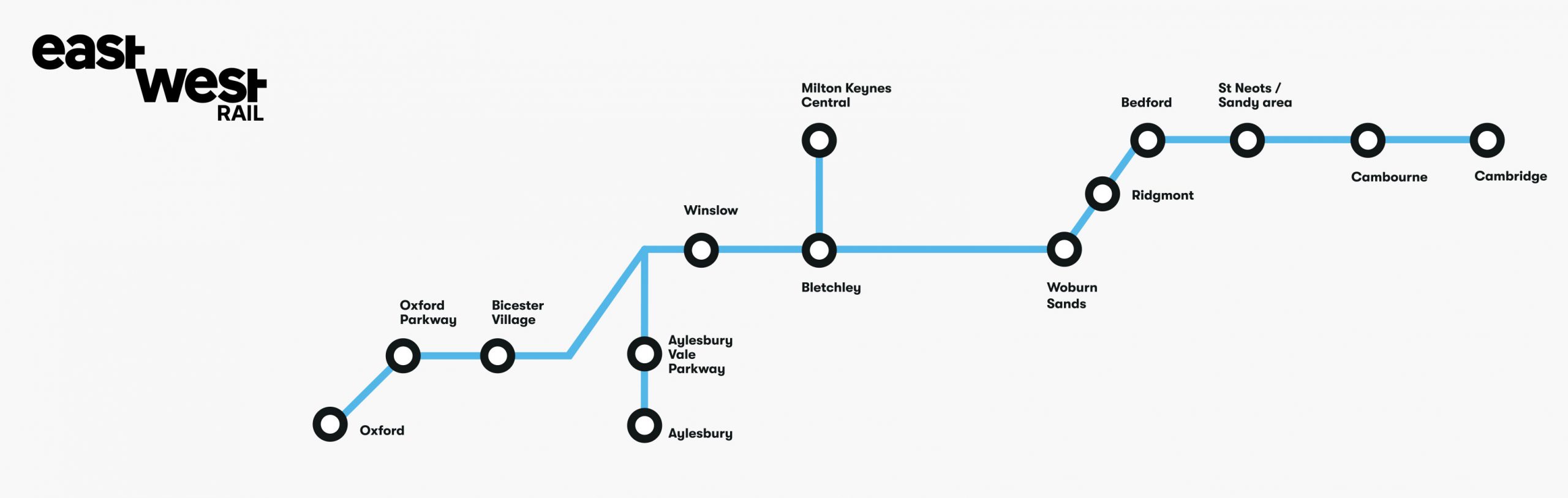
why not just knuckle down and get on with the MKC chord?,it's far ,far more useful.
I would have thought that purchase of necessary land to do the job would be obligatory, with a resale of surplus assets done after completion.I presume that they have an option to purchase the land if it's required. They may rent it for the duration of construction if it's only used for construction access. Generally if a public agency actually buys land outright for construction purposes, they immediately fence it off to mark the new land boundary (this is very noticeable with road projects). Someone almost certainly knows better than I do.
just taking at face value, the above implies that the viaduct was intended to be just a facelift,but upon further structural inspection has turned out to be something rather more serious.I don’t think the planning application implies any sort of deviation at all, the line of the viaduct will be exactly as it is now, because only a subset of the supports are being replaced.
Not at this point, because we can see from the planning drawings they aren’t doing that...just taking at face value, the above implies that the viaduct was intended to be just a facelift,but upon further structural inspection has turned out to be something rather more serious.
at which point do you say "ok,lets start again with a blank canvas"
from the planning drawings it probably looks fine...what have the earthworks guys discovered?Not at this point, because we can see from the planning drawings they aren’t doing that...
Does that mean they own that land or do they just have to compensate the landowners later if the land is used?
thanks - so the owners get paid and then a refund if not needed? Seems a bit of a legal palaver!It will be the ownership boundary. Note that in some cases, the ownership will be temporary.
thanks - so the owners get paid and then a refund if not needed? Seems a bit of a legal palaver!