James Finch
Member
It's quite a smooth alignment. What's the max speed, 160kph?Another super drone video on You Tube from The Boy. EWR from Calvert to Winslow.
It's quite a smooth alignment. What's the max speed, 160kph?Another super drone video on You Tube from The Boy. EWR from Calvert to Winslow.
Yes, but normally the 100 mph definition would be used. No change to the Bletchley to Bedford route authorised yet though.It's quite a smooth alignment. What's the max speed, 160kph?
Double track all the way to the HS2 limits - within about 50 yards of here: https://goo.gl/maps/Zw36nHoC11Fek1YC7Apologies if this has been answered recently, but how far does track currently reach going eastward from Bicester?
Thanks. From the video in #1140 it appears they can keep going for a few miles on the Winslow side before they run into the HS2 boundary. It will be interesting to see how things develop over the summer.Double track all the way to the HS2 limits - within about 50 yards of here: https://goo.gl/maps/Zw36nHoC11Fek1YC7
For getting your bearings, in the opening shot of that latest video the view is from just above where the two tracks coming from Bicester end, but unfortunately they aren’t shown. If you go back to the same YouTuber‘s earlier video in post #1099 theres a section showing the tracks approaching a couple of hundred yards back from the bridge, at about 11m 15s.Thanks. From the video in #1140 it appears they can keep going for a few miles on the Winslow side before they run into the HS2 boundary. It will be interesting to see how things develop over the summer.
I think there is still a fence visible in the recent video, just about to pass out of shot at the bottom of the screen at 0m 16s, but as you say, visibility of the tracks is narrowly missed.Just beyond the bridge, (where the ballast looks as though it gets wider), is the EWR/HS2 contract boundary. It’s where the ground changes from cutting to embankment, a while back there was an HS2 boundary fence across the earthworks.
Yes that’s the place, and easier to see in the field alongside.I think there is still a fence visible in the recent video, just about to pass out of shot at the bottom of the screen at 0m 16s.
Thanks. That doesn't seem very reassuring in its implications for the question I keep asking, which is at what date the length of EWR trackbed currently in HS2 hands will be returned to EWR for tracklaying. It was supposed to be "the middle of" this year.There has been a couple of questions or remarks lately regarding the construction timeline. The following link to an HS2 document mentions the works being undertaken from the Calvert area to Quainton. Page 9 onwards.
Buckinghamshire and Oxfordshire, Summer 2023
A useful overview but as we know things change.
I think those recent questions might be in the EWR consultation thread, in case anyone’s wondering…There has been a couple of questions or remarks lately regarding the construction timeline.
Indeed. As of last Saturday (3rd June) - you can see the embankment that has been built up, and gap immediately before the HS2/EWR bridge (left == east) and immediately after.I could not agree more, I know EWR wanted and hoped for an earlier handover. If I recall correctly, it was expected to be Mid-July or before. ..


Is it possible to explain what we're looking at that, there, please? I assume the overbridge in the distance is the EWR bridge over the HS2 formation? Many thanks.East West construction has finally began in the HS2 compound. Photos and update from Phil Marsh:
That’s looking west at the new Addison Road Bridge in the foreground, that’s the one that’s been lengthened significantly because the overall formation there will includes the east end access to the HS2 maintenance depot. The next new bridge that’s rather more difficult to see, (eg in the second photo), takes EWR over HS2, and the brick bridge in the far distance is Gawcott Road bridge that is yet to be removed.Is it possible to explain what we're looking at that, there, please? I assume the overbridge in the distance is the EWR bridge over the HS2 formation? Many thanks.
Brilliant - that works for me, at least - I've managed to orientate it against the Calvert HS2 plan. Thank you.That’s looking west at the new Addison Road Bridge in the foreground, that’s the one that’s been lengthened significantly because the overall formation there will includes the east end access to the HS2 maintenance depot. The next new bridge that’s rather more difficult to see, (eg in the second photo), takes EWR over HS2, and the brick bridge in the far distance is Gawcott Road bridge that is yet to be removed.
I think the angled part of the ballast on the right hand side is either to be a junction between EWR and the depot, or an entrance to a loop. You can use that angled ballast to find the same location in the recent video, post #1140.
(But please reply if that’s not clear and I’ll annotate a drawing.)
To quote Hot Fuzz, “Very Good, What he said”That’s looking west at the new Addison Road Bridge in the foreground, that’s the one that’s been lengthened significantly because the overall formation there will includes the east end access to the HS2 maintenance depot. The next new bridge that’s rather more difficult to see, (eg in the second photo), takes EWR over HS2, and the brick bridge in the far distance is Gawcott Road bridge that is yet to be removed.
I think the angled part of the ballast on the right hand side is either to be a junction between EWR and the depot, or an entrance to a loop. You can use that angled ballast to find the same location in the recent video, post #1140.
(But please reply if that’s not clear and I’ll annotate a drawing.)
Just started, Twitter link in #1155, is that reassuring?Thanks. That doesn't seem very reassuring in its implications for the question I keep asking, which is at what date the length of EWR trackbed currently in HS2 hands will be returned to EWR for tracklaying. It was supposed to be "the middle of" this year.
Yes. Presumably this is the result of the cooperation mentioned in #1073.Just started, Twitter link in #1155, is that reassuring?
Just trying to get my bearings - is this view generally looking south along the HS2 alignment, with the Girder bridge in the foreground being the eventual EWR overbridge, and the concrete bridge in the background a road bridge?Another photo from Phil Marsh tonight, although taken with a telephoto lens, it shows the extent of the newly laid track towards the newly installed bridge.
Isn’t it Signalling and Communications? With PWay (permanent way) being the actual track?Switches and crossings, i.e. pointwork / junctions.
No, taken from the existing and yet to be demolished Steeple Claydon road bridge, looking eastwards along the EWR formation towards the new 4 track width Addison Road bridge. The ramp in the foreground will take EWR up and over the road the phot is taken from (when that switches to an under bridge) and HS2 - if that makes sense (long long day here!).Just trying to get my bearings - is this view generally looking south along the HS2 alignment, with the Girder bridge in the foreground being the eventual EWR overbridge, and the concrete bridge in the background a road bridge?
Much obliged, that makes sense why there's track there now!No, taken from the existing and yet to be demolished Steeple Claydon road bridge, looking eastwards along the EWR formation towards the new 4 track width Addison Road bridge. The ramp in the foreground will take EWR up and over the road the phot is taken from (when that switches to an under bridge) and HS2 - if that makes sense (long long day here!).
Also there’s the new concrete Queen Catherine Road bridge in the far distance, which has replaced a level crossing, it is nearly 3 km away from the photographer.No, taken from the existing and yet to be demolished Steeple Claydon road bridge, looking eastwards along the EWR formation towards the new 4 track width Addison Road bridge. The ramp in the foreground will take EWR up and over the road the phot is taken from (when that switches to an under bridge) and HS2 - if that makes sense (long long day here!).
No Switches & Crossings is correct.Isn’t it Signalling and Communications? With PWay (permanent way) being the actual track?
Aren't comms part of S&T (Signalling and Telephones)?Isn’t it Signalling and Communications? With PWay (permanent way) being the actual track?
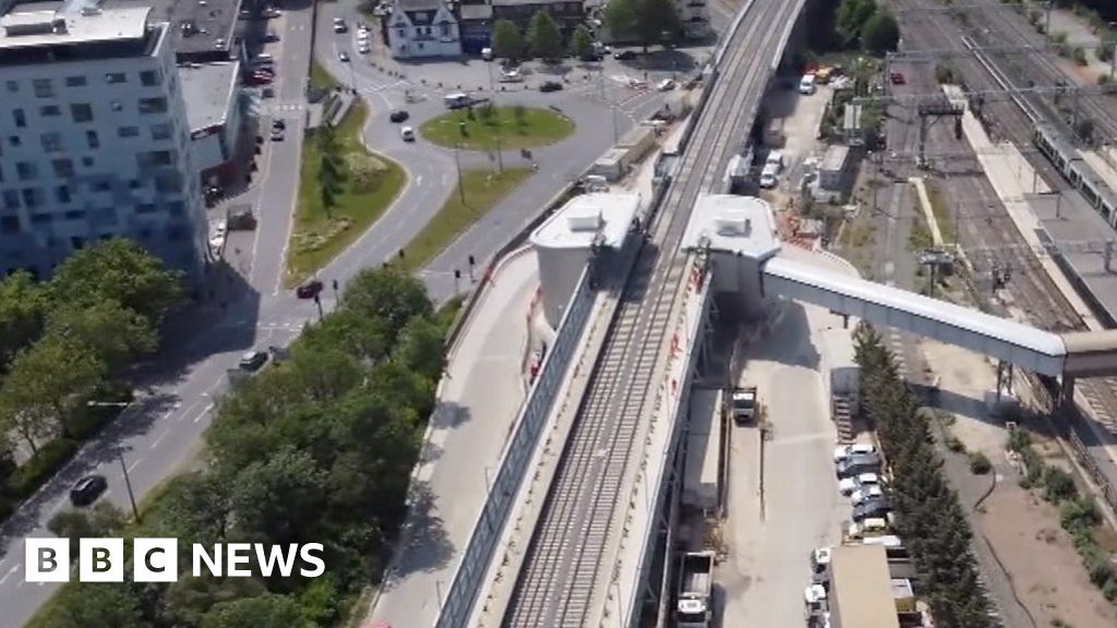
The first stage of the £5bn East West Rail project connecting Oxford to Cambridge is on its way to completion.
Work began on the 21-mile (33km) £760m Bicester to Bletchley stretch of the railway in 2020 and is on schedule to be finished by the middle of 2024.
Aerial pictures show an updated Bletchley station, with new platforms and tracks that are due to see their first services from early 2025.