• Our new ticketing site is now live! Using either this or the original site (both powered by TrainSplit) helps support the running of the forum with every ticket purchase! Find out more and ask any questions/give us feedback in this thread!

How Did They Count Bridges

Status
Not open for further replies.

Andy873

Established Member
Joined
23 Mar 2017
Messages
1,218
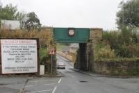
This might sound a simple question, but when is a bridge counted as a bridge?

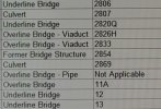
Looking at the old OS maps from 1910 I have been trying to count the number of bridges along my old branch line. Now I know certain bridge numbers. Take one of them (bridge No 17), as I go along the route there are obvious ones such as over a brook or an occupation bridge, but there are others on the maps which look like (for instance) cattle creeps. Depending on which of these little bridges I count, I sometimes get to bridge 17 as 17, sometimes its number is greater, sometimes less.

Questions:

What really constitutes a bridge?

Did bridge numbers change? If you add an extra bridge would you really have renumbered the rest of them? or said the new bridge is 10A and the original bridge 10 as 10B?

If you have a 50 foot embankment with access through it at the base (in this case an old tramroad) would that count as a bridge?

Would you count a footbridge at a station linking two platforms?

At first glance it sounds a simple question, on opening the line had 39 bridges, by say 1910 I can easily count over 50. I know surroundings change over time.

Would love your thoughts on the subject.

Thanks.
 
Sponsor Post - registered members do not see these adverts; click here to register, or click here to log in
R

RailUK Forums

Big Jumby 74

Established Member
Joined
12 Feb 2022
Messages
1,540
Location
UK
I have an ancient Bridge book from SWD (SR), although there are no references as to method of bridge numbering or any rules that the Civil Engineers adhered to when it came to additional bridge structures being added, or what indeed constituted a 'bridge'. So, I can only comment on what I interpret from what is in front of me.

It would appear that when additional structures were added, lettered suffixes came to play, ie: bridge 1, 1A, 1B etc, so possibly quite a few suffixes could be used before the next 'original' structure (and its number) were reached. See below reference 'Hook'.

I would guess that any through way under an embankment (however tall the embankment) would still be classed as a bridge/culvert.

Footbridge's are classed as a numbered structure. That's a definite, those at my local station all being numbered. But also footbridges that were former 'rights of way' and didn't give access to the platforms, such as at Seaton Junction.

The subject as with many other railway questions, often varies in the detail, depending on the area (old railway company) concerned. If in more recent times, NR and its predecessors have attempted to 'standardise' things, I can not say.

As an example in relation to my SR book, of the possible complexities that some areas might be subject to, a few observations from same:

Starting out from Waterloo, every bridge and signal gantry had it's own number (the latter for the most part stretched across eight running lines, hence the 'bridge' status), and they were numbered from 'A1' Leake Street bridge, which passes under the station at approximately the platform end ramps area. So the under station arches are NOT included within this document, though will no doubt have their own series of identifications? Then onwards, A3 being the cab road entrance to the station off Westminster bridge road, whereas A4 was the main Westminster Bridge road bridge itself, A5 the first cross track signal gantry, and so on.

This carried on until Nine Elms viaduct, with the loco shed and works on the Down side and the marshalling yard on the Up side. The viaduct is simply numbered 'arches 51-57'. This likely refers to those arches through which either rail or road could pass under the viaduct, from the down side sidings to the Up yard sidings, not all the many under viaduct arches that formed storage units etc. Although again these will likely be identified in their own way I guess?

The 'A' series of numbering then ends at A38 (Loco shed Junction signal box), the next structure being Thessaly Road bridge (rail over road) which is 'bridge 1'. Cross track signal gantries still being counted, but the more usual 'suffix' type numbering being the order of the day.

Taking the recent Hook landslide site in to account. Bridge 122 (rail over road) is Holt Lane Bridge, then there is 122A (culvert), 122B (signal gantry), 122C (signal gantry), 122D (detail faded!), 122E (signal gantry), 122F (culvert) then 123 (the road over bridge at Hook station). These signal gantries will all be cross (four running lines) track structures, so hence still 'bridge' status.

Next time I pass by my local station (which comes within this book) I will try and remember to make a note to compare with this old book. I suspect there may have been some changes since it was printed?
 

John Webb

Established Member
Joined
5 Jun 2010
Messages
3,516
Location
St Albans
I assume the numbering of bridges was adopted from the canals - most bridges over a canal were clearly numbered with a cast-iron plaque. Certainly when an extra bridge was built it was usually given a number with a suffix. But I suspect the numbering depended on whether the canal company had built the additional bridge or someone else had - for example when the railways appeared and they built across the canal and were responsible for its upkeep I'm pretty sure the canal company didn't bother numbering it!

I doubt too if there was ever any wholesale renumbering - too costly and with the potential for records to become confused.

Is it possible the railway companies distinguished between bridges (under or over) from culverts and other minor civil engineering works?
 

zwk500

Veteran Member
Joined
20 Jan 2020
Messages
15,500
Location
Bristol
I assume the numbering of bridges was adopted from the canals - most bridges over a canal were clearly numbered with a cast-iron plaque. Certainly when an extra bridge was built it was usually given a number with a suffix. But I suspect the numbering depended on whether the canal company had built the additional bridge or someone else had - for example when the railways appeared and they built across the canal and were responsible for its upkeep I'm pretty sure the canal company didn't bother numbering it!
There are some bridges over the Grand Union canal at Wolverton that were almost certainly railway-built yet IIRC bear Grand Union Canal numbers. I'm fairly sure other modern road bridges have also been given bridge numbers to assist boaters when works take place).
I doubt too if there was ever any wholesale renumbering - too costly and with the potential for records to become confused.
I'm not aware of any, there may have been tidying up at times.
Is it possible the railway companies distinguished between bridges (under or over) from culverts and other minor civil engineering works?
Some culverts seem to not be counted, others do. As ever, recordkeeping is not always consistent on the railway!
 

Hadrian

Member
Joined
28 Jan 2019
Messages
45
Location
Bardon Mill
As I understand it from ex-colleagues: renumbering bridges happened extremely rarely (almost never) because of the extent of paper records about bridge works (maintenance and renewal etc) which were tied to the bridge number (within the line of route). It was also very unusual for a route to be remilaged (usually a change of origin for measurement) because of the scale of paper records which were milage based. All of these records were assembled long before computers made indexing a much less onerous task.
 

zwk500

Veteran Member
Joined
20 Jan 2020
Messages
15,500
Location
Bristol
As I understand it from ex-colleagues: renumbering bridges happened extremely rarely (almost never) because of the extent of paper records about bridge works (maintenance and renewal etc) which were tied to the bridge number (within the line of route). It was also very unusual for a route to be remilaged (usually a change of origin for measurement) because of the scale of paper records which were milage based. All of these records were assembled long before computers made indexing a much less onerous task.
Computers haven't changed very much, because lots of the paper records haven't been properly digitised, merely being scanned as an image file.
 

bramling

Veteran Member
Joined
5 Mar 2012
Messages
18,851
Location
Hertfordshire / Teesdale
I'm not aware of any, there may have been tidying up at times.

Someone could probably write a massive thesis on this topic. I don’t really know much, but I have a few old Bridge books so have picked up a few bits of knowledge.

The first thing to say is there’s massive variation between companies and areas, so there is no one standard policy anywhere.

The LBSCR didn’t use a numbering system, so all their bridges were simply referred to by miles and chains. This persisted into BR days, though eventually numbers were allocated.

The western region still use miles and chains to this day, though in their case many (but not all) lines *did* have numbers allocated according to the bridge registers. Seems another example of the western region simply wanting to be different!

The GER is unusual in that they did a comprehensive numbering exercise at some point, so every bridge on their system has a unique number, rather than the more normal method of every line starting from 1. There’s elements of this on the south eastern division of the southern too, though not sure how how came about there.

It’s generally rare for significant renumbering to have occurred, though not unheard of. Some companies had stuff like culverts and tunnels numbered, others didn’t.

So like many things on the railway it’s all rather messy and inconsistent, but works.
 

zwk500

Veteran Member
Joined
20 Jan 2020
Messages
15,500
Location
Bristol
Seems another example of the western region simply wanting to be different!
Western men will tell you it's them being 'correct' :D I used to joke with colleagues that the Western had it's own Prayer - As it was by Brunel, is now, and Ever Shall be. For Ever and Ever.
So like many things on the railway it’s all rather messy and inconsistent, but works.
BIB - The extent to which it works is questionable.
 

DelW

Established Member
Joined
15 Jan 2015
Messages
4,894
Having worked (many years ago) on the design and construction of roads and motorways, where similar issues arise, I'd say there can't be any hard and fast rules about when a large culvert becomes a small bridge, or indeed when a long bridge becomes a short viaduct. In my experience, it's purely down to the opinions of the design engineers as to which category each structure is placed into.

It's another example of the difficulty of dividing a continuous variable into discrete subdivisions. See also the paradox of the heap:
A typical formulation involves a heap of sand, from which grains are removed individually. With the assumption that removing a single grain does not cause a heap to become a non-heap, the paradox is to consider what happens when the process is repeated enough times that only one grain remains: is it still a heap? If not, when did it change from a heap to a non-heap?
 

D6130

Established Member
Joined
12 Jan 2021
Messages
7,422
Location
West Yorkshire/Tuscany
It was also very unusual for a route to be remilaged (usually a change of origin for measurement) because of the scale of paper records which were milage based
The entire Midland Railway network was re-mileaged in about 1907, with the mileposts generally giving the distance from St Pancras by the shortest possible route. Exceptions to this were the Derby-Bristol line - with mileposts measured from London Road Junction, Derby - and certain branch lines (e.g. the Keighley & Worth valley, which continued to - and still does - have posts measured from Keighley Station Junction). However, from experience of driving over the Settle & Carlisle & Leeds-Bradford/'Little North Western' lines, I get the impression that their bridge numbering remained the same (i.e. on a line-by-line basis) with culverts being un-numbered but marked by small white posts with an oval-shaped white plate bearing a black letter 'C'.
 

Beebman

Member
Joined
17 Feb 2011
Messages
805
The GER is unusual in that they did a comprehensive numbering exercise at some point, so every bridge on their system has a unique number, rather than the more normal method of every line starting from 1. There’s elements of this on the south eastern division of the southern too, though not sure how how came about there.
When the Stansted Airport branch was built the bridge numbers were added to the GER sequence, ISTR they're 2454 to 2463. I'm pretty sure that '1' was that footbridge which used to run across the platforms at Liverpool Street.

The SER and the LCDR each did a similar thing but how they took care of all their duplicates after merger I don't know, they certainly weren't renumbered, even today the lines from Charing Cross and Victoria to Dover each have sequences starting from '1' at their respective London termini.

I have an ancient Bridge book from SWD (SR), although there are no references as to method of bridge numbering or any rules that the Civil Engineers adhered to when it came to additional bridge structures being added, or what indeed constituted a 'bridge'. So, I can only comment on what I interpret from what is in front of me.
Is it old enough to include the main line to Plymouth? If so could you please take a look to see what the highest numbered bridge was? I believe that they ran in one continuous sequence from '1' to about 730-ish at the original LSWR-GWR junction at St.Budeaux (but the Plymouth Friary branch had a separate short sequence starting at '1').
 

Big Jumby 74

Established Member
Joined
12 Feb 2022
Messages
1,540
Location
UK
Is it old enough to include the main line to Plymouth?
Regret not that old as it turns out, having mentioned Seaton Junction (off top of my head from personal memory) above. I would say its late 60's. IoW only consists of Ryde-Shanklin, and everything West of MP 117.40 on the WoE main line has been given over to that other region, so gets no mention!
 

bramling

Veteran Member
Joined
5 Mar 2012
Messages
18,851
Location
Hertfordshire / Teesdale
Regret not that old as it turns out, having mentioned Seaton Junction (off top of my head from personal memory) above. I would say its late 60's. IoW only consists of Ryde-Shanklin, and everything West of MP 117.40 on the WoE main line has been given over to that other region, so gets no mention!

One of my registers I’m pretty sure includes Plymouth. I’ll have a look when I get five minutes.
 

edwin_m

Veteran Member
Joined
21 Apr 2013
Messages
26,881
Location
Nottingham
The entire Midland Railway network was re-mileaged in about 1907, with the mileposts generally giving the distance from St Pancras by the shortest possible route. Exceptions to this were the Derby-Bristol line - with mileposts measured from London Road Junction, Derby - and certain branch lines (e.g. the Keighley & Worth valley, which continued to - and still does - have posts measured from Keighley Station Junction). However, from experience of driving over the Settle & Carlisle & Leeds-Bradford/'Little North Western' lines, I get the impression that their bridge numbering remained the same (i.e. on a line-by-line basis) with culverts being un-numbered but marked by small white posts with an oval-shaped white plate bearing a black letter 'C'.
Actually both these branches were entirely consistent with the numbering scheme, which dictated that any branch that started at a trailing junction (as seen when approaching from St Pancras) would increase from a zero at the junction.


A branch joining the main line by a trailing junction had its own zero-point at the junction and was measured from that point. Thus the Lincoln line begins with a zero at Nottingham London Road Junction.
Unfortunately this article doesn't cover structure numbers, so I can't say if they were re-numbered at the same time.
 

30907

Veteran Member
Joined
30 Sep 2012
Messages
20,817
Location
Airedale
Unfortunately this article doesn't cover structure numbers, so I can't say if they were re-numbered at the same time.
My guess is "not" - certainly I have seen canal bridges with a "D" suffix, suggesting that the numbering goes back a long way :)
 

Andy873

Established Member
Joined
23 Mar 2017
Messages
1,218
Thanks everyone.

About bridges - sounds a simple subject but as we can see, it's not. Good points beings raised here, I like the one about when does a structure become a bridge, and when does a bridge become a viaduct etc.

One late addition to the bridges on my old line is the one carrying the M65 over it, this was added in the 1980's and I believe this one was never numbered. Being the only motorway bridge over the line I guess from a railway point of view it didn't need to be numbered.

On the 1910 OS map it looks like cattle creeps and walkways under the line are not clearly defined, i.e. you can't tell which is which.
 

Ken H

Established Member
Joined
11 Nov 2018
Messages
6,626
Location
N Yorks
The entire Midland Railway network was re-mileaged in about 1907, with the mileposts generally giving the distance from St Pancras by the shortest possible route. Exceptions to this were the Derby-Bristol line - with mileposts measured from London Road Junction, Derby - and certain branch lines (e.g. the Keighley & Worth valley, which continued to - and still does - have posts measured from Keighley Station Junction). However, from experience of driving over the Settle & Carlisle & Leeds-Bradford/'Little North Western' lines, I get the impression that their bridge numbering remained the same (i.e. on a line-by-line basis) with culverts being un-numbered but marked by small white posts with an oval-shaped white plate bearing a black letter 'C'.
S&C starts at 1 at Settle Jct. 1 is a small bridge for farmers access. 2 is over the A65.

There is a road bridge where the B6479 crosses the railway in Langcliffe. But they built a footbridge next to it as the road bridge was dangerous to pedestrians. I assume it has the same number as the road bridge but with a suffix.
 

Ken H

Established Member
Joined
11 Nov 2018
Messages
6,626
Location
N Yorks
On the S&C i think viaducts get one number. But each pier is also numbered.
 

Big Jumby 74

Established Member
Joined
12 Feb 2022
Messages
1,540
Location
UK
I like the one about when does a structure become a bridge, and when does a bridge become a viaduct etc
Got me thinking about tunnels, as in when does a bridge become a tunnel. On certain gradient profile diagrams both tunnel and bridge locations are indicated by differing symbols, tunnels being easily identified. But these diagrams do not show actual tunnel lengths or indicate when a bridge becomes a tunnel (by length).

On the IoW between Ashey and Smallbrook Jn there is what is known as 'Long Arch' where a minor road crosses above at an angle. Can't find reference to it's length although have walked through it many years ago, but believe it is technically a 'bridge'. Referring to the book 'Rails in the Isle of Wight' (P.C.Allen and A.B.MacLeod - 1967) there is reference to all the 'tunnels' on the Island, and they range from the longest, Ventnor at 1,312 yards to the shortest (Newport - on the Ryde road) at 73 yards. The aforementioned Long Arch is not thus listed, so I assume it is a 'bridge'.

This then led me to one of my own sectional appendices,(BR30022/1982), and a quick glance shows at Winchester, St.Cross 'tunnel' which is only 62 yards in length. But such structures as the bridge at the London end of Bournemouth Central is not listed as such, so although it may look like a short tunnel to some, it is obviously a 'bridge' !
 

150219

Member
Joined
24 Nov 2009
Messages
384
It would be more proper to call them structure numbers rather than bridge numbers. As already mentioned in the replies above, they encompass bridges, tunnels, viaducts, etc. Depending on the practice employed by the company that built the infrastructure would dictate whether 'something' would get a structure number or not and to what convention, be it an individual asset record number or the mileage at which the structure is/was. Culverts on some lines will have structure numbers, some won't. However the ones that won't will still be on the asset register and may be/will probably identified by the mileage.

Tunnels should refer to bores, with a cut and cover method being properly referred to as covered ways. Again, as already referenced the practice can become confused depending on which practice is employed and the understanding of who is in charge of the infrastructure.

Also worth noting that any structures that are 'owned' by the railway, but aren't on the line itself will also have a structure number. Therefore whilst counting the number of structures from a to b will generally be OK, it might not count that a road next to the railway also has a structure number because, it was diverted when the railway was built (for example).
 

etr221

Established Member
Joined
10 Mar 2018
Messages
1,378
Got me thinking about tunnels, as in when does a bridge become a tunnel. On certain gradient profile diagrams both tunnel and bridge locations are indicated by differing symbols, tunnels being easily identified. But these diagrams do not show actual tunnel lengths or indicate when a bridge becomes a tunnel (by length).

On the IoW between Ashey and Smallbrook Jn there is what is known as 'Long Arch' where a minor road crosses above at an angle. Can't find reference to it's length although have walked through it many years ago, but believe it is technically a 'bridge'. Referring to the book 'Rails in the Isle of Wight' (P.C.Allen and A.B.MacLeod - 1967) there is reference to all the 'tunnels' on the Island, and they range from the longest, Ventnor at 1,312 yards to the shortest (Newport - on the Ryde road) at 73 yards. The aforementioned Long Arch is not thus listed, so I assume it is a 'bridge'.

This then led me to one of my own sectional appendices,(BR30022/1982), and a quick glance shows at Winchester, St.Cross 'tunnel' which is only 62 yards in length. But such structures as the bridge at the London end of Bournemouth Central is not listed as such, so although it may look like a short tunnel to some, it is obviously a 'bridge' !
Something I came across a good while ago is that operators and civil engineers have different definitions of 'tunnel': operators are only interesed in length - and hence whether special instructions come into play - whereas civil engineers consider what is on top: to them a tunnel is a hole (however long) dug (somehow) through ground. If, structurally, it's a bridge (with a deck above), then that's what it is - or it might be termed a 'covered way'.
 

Big Jumby 74

Established Member
Joined
12 Feb 2022
Messages
1,540
Location
UK
Something I came across a good while ago is that operators and civil engineers have different definitions of 'tunnel': operators are only interesed in length - and hence whether special instructions come into play - whereas civil engineers consider what is on top: to them a tunnel is a hole (however long) dug (somehow) through ground. If, structurally, it's a bridge (with a deck above), then that's what it is - or it might be termed a 'covered way'.
I've been glancing through a number of documents I still have. Some, such as the 1960 sectional appendix for the SWD (SR), but also the signalling regulation/instruction books that I was issued with myself (BR29960/BR30062) when I was a 'bobby', given that I had a tunnel on my patch, but can't find any specific reference(s) to 'tunnels'. Like I say, in the here and now I have just been glancing through same so may have forgotten/missed something this far down the line. For those in the know will understand how an otherwise deathly quiet 22.00-06.00 shift (or is it 23.00-07.00 these days?) could be easily taken up by reading the above regulations and (hopefully) some of same would stick in one's memory!
 

Beebman

Member
Joined
17 Feb 2011
Messages
805
On the S&C i think viaducts get one number. But each pier is also numbered.
I've just been looking at my copy of 'Stations & Structures of the Settle & Carlisle Railway' (published in 1986 by OPC) and that includes an official MR drawing of Arten Gill Viaduct (S&C structure no. 84) which shows the piers numbered from 1 to 10.

The book is very good for anyone interested in bridges, tunnels and viaducts with many diagrams and photos. It includes the structure numbers in photo captions and plans but there's no comprehensive listing. The track plan of the Petteril Bridge Jct area where the MR joined the NER line from Newcastle shows the highest numbered bridge on the S&C main line as 360, however 361-363 could be found at Petteril Goods which was to the south and slightly to the west of the junction. (362 was an MR-owned road over river bridge giving access to slaughter houses in the goods yard.)

However what has always intrigued me ever since I first read the book can be found on the last page in a caption for a photo of the MR goods yards at Dentonholme to the west of Carlisle Citadel Station. It says that "the numbering of structures continued here in the Midland sequence as far as the bridge over the River Caldew". I've never been able to find any evidence of this but I have seen a plan showing mileages in this area measured from St.Pancras. Whether the bridge numbering continued in the S&C sequence I just don't know.
 

Annetts key

Established Member
Joined
13 Feb 2021
Messages
3,006
Location
West is best
Also, to add… bridges may be removed when no longer required. Plus a bridge may be replaced with a different structure near to the existing structure. Sometimes the new bridge is built before the old one is removed, sometimes the existing bridge is removed first.

How the above affects the numbering, I don’t know.

I do know that some parts of the Western do have bridge numbers on some structures. Bridge/structure numbers also sometimes appear on signalling plans. But many bridges/structures don’t have any sign on them showing any number. That may or may not mean that they have been allocated a number.

New bridges, as far as I am aware (and my sample size is very small, so this may not be true elsewhere), only have signs showing the mileage and chainage. Again, that may or may not mean that they have been allocated a number.

Also, some of the lines that are now Western, were not built by the GWR (or associated other railway companies). We have various lines including parts of former Midland lines. And I think the bridges on those lines do have numbers.
 

edwin_m

Veteran Member
Joined
21 Apr 2013
Messages
26,881
Location
Nottingham
Where a bridge is at risk of impact from a road vehicle, there is usually a notice underneath giving a contact phone number if this happens (the newer ones say "The Railway Authority", presumably so they don't have to change them all when Network Rail decides to re-brand...). These also give the Engineers Line Reference and the structure number, which should allow the person receiving the call to identify it immediately.

So you can get some bridge numbers off Streetview. Here's one at Bathampton...
The structure number may be part of the writing that's too small to read, but ELR and mileage are stencilled on just below the plate.
 
Last edited:

Andy873

Established Member
Joined
23 Mar 2017
Messages
1,218
Where a bridge is at risk of impact from a road vehicle, there is usually a notice underneath
And here's one on my old branch line, you will notice the sign mentions PRG (line ref) and 1m 2ch (1 mile, 2 chains):


A double decker bus struck this bridge in the 1980's destroying the roof of the bus - fortunately all the passengers were on the lower deck. I can't see any bridge number here but I know it's bridge no 5.

This then led me to one of my own sectional appendices,(BR30022/1982), and a quick glance shows at Winchester, St.Cross 'tunnel' which is only 62 yards in length.
Glad you mentioned the sectional appendices - I was trying to find what number Martholme viaduct was, on my count I was getting 31, so I went back and re-read the 1960 sectional appendix and it's marked down as bridge 30.

I was out by 1 because on one side approaching the viaduct, the embankment has a 130 foot tunnel through it for an old tramroad and I was counting this by mistake. It all comes back to when is a bridge a bridge...

If we say a bridge is a structure that connect two ends together that's easy to understand. If we take the above tunnel, it's not a bridge because the embankment it runs through is unbroken.
 

2192

Member
Joined
16 Aug 2020
Messages
372
Location
Derby UK
The entire Midland Railway network was re-mileaged in about 1907, with the mileposts generally giving the distance from St Pancras by the shortest possible route. Exceptions to this were the Derby-Bristol line - with mileposts measured from London Road Junction, Derby - and certain branch lines (e.g. the Keighley & Worth valley, which continued to - and still does - have posts measured from Keighley Station Junction). However, from experience of driving over the Settle & Carlisle & Leeds-Bradford/'Little North Western' lines, I get the impression that their bridge numbering remained the same (i.e. on a line-by-line basis) with culverts being un-numbered but marked by small white posts with an oval-shaped white plate bearing a black letter 'C'.
One would hope that the shareholders asked the directors at the next AGM how many extra tickets re-mileaging sold; and how much extra freight revenue it brought in!
 

150219

Member
Joined
24 Nov 2009
Messages
384
And here's one on my old branch line, you will notice the sign mentions PRG (line ref) and 1m 2ch (1 mile, 2 chains):


A double decker bus struck this bridge in the 1980's destroying the roof of the bus - fortunately all the passengers were on the lower deck. I can't see any bridge number here but I know it's bridge no 5.


Glad you mentioned the sectional appendices - I was trying to find what number Martholme viaduct was, on my count I was getting 31, so I went back and re-read the 1960 sectional appendix and it's marked down as bridge 30.

I was out by 1 because on one side approaching the viaduct, the embankment has a 130 foot tunnel through it for an old tramroad and I was counting this by mistake. It all comes back to when is a bridge a bridge...

If we say a bridge is a structure that connect two ends together that's easy to understand. If we take the above tunnel, it's not a bridge because the embankment it runs through is unbroken.
That 130 foot tunnel may well have a structure number too, but it may be 30a or 30b (for example). Remember for numbering purposes it's the structures that have identities, not just bridges. Or equally the tunnel you refer to may not have a suffix, e.g., a, b, etc. and it may be that another bridge does. Without having access to the asset register or equivalent it's not going to be that easy to deduce, only the most likely based on assumption.

Also, to add… bridges may be removed when no longer required. Plus a bridge may be replaced with a different structure near to the existing structure. Sometimes the new bridge is built before the old one is removed, sometimes the existing bridge is removed first.

How the above affects the numbering, I don’t know.

I do know that some parts of the Western do have bridge numbers on some structures. Bridge/structure numbers also sometimes appear on signalling plans. But many bridges/structures don’t have any sign on them showing any number. That may or may not mean that they have been allocated a number.

New bridges, as far as I am aware (and my sample size is very small, so this may not be true elsewhere), only have signs showing the mileage and chainage. Again, that may or may not mean that they have been allocated a number.

Also, some of the lines that are now Western, were not built by the GWR (or associated other railway companies). We have various lines including parts of former Midland lines. And I think the bridges on those lines do have numbers.
It depends on the convention which is applied. Most (if not all) of the structures maintained by the Great Western Route are referred to by their mileage (and accompanying ELR, e.g., MLN1). However the asset register does list some of their structure numbers too, where applicable. New structures on the Central Route however carry numbers.

Example attached showing the split between routes on the same line, i.e., change in mileage and numbers for the identities and the variation in structures and also what isn't applicable in this case.
 

Attachments

  • 1677656369440.jpg
    1677656369440.jpg
    402.4 KB · Views: 8
Last edited:

Cowley

Forum Staff
Staff Member
Global Moderator
Joined
15 Apr 2016
Messages
17,407
Location
Devon
Some of the discussion around altered mileages are now in the thread below. Obviously it isn’t a perfect split off though so if you think we need to move more over then let’s us know please. :)
 
Status
Not open for further replies.

Top