• Our new ticketing site is now live! Using either this or the original site (both powered by TrainSplit) helps support the running of the forum with every ticket purchase! Find out more and ask any questions/give us feedback in this thread!

Landslip in Sonning Cutting

Sponsor Post - registered members do not see these adverts; click here to register, or click here to log in
R

RailUK Forums

Neil Holland

Member
Joined
20 Sep 2016
Messages
5
Thanks, all. Things seem to be OK as of now and am positive for tonight's journey west. This thread has been the most complete commentary on what's actually been happening than any other I could find.
 

MikeWM

Established Member
Joined
26 Mar 2010
Messages
4,490
Location
Ely
Agree it was fairly grim, just to note here for the archive, 1C22 1655 Reading to Taunton (usually 1630 from Paddington) left Reading heading *East* with announcements on platform to warn people, it then headed into the Kennet loop, reversed and came back through the station at speed. Not sure if this was the only recycling that happened this way.

Ah, I was trying to catch that exact service at Temple Meads yesterday evening and wondered how it ended up being late (and why it was marked as 'not stopping' at Reading on RTT). Interesting, thanks!
 
Joined
26 Jun 2019
Messages
72
Agree it was fairly grim, just to note here for the archive, 1C22 1655 Reading to Taunton (usually 1630 from Paddington) left Reading heading *East* with announcements on platform to warn people, it then headed into the Kennet loop, reversed and came back through the station at speed. Not sure if this was the only recycling that happened this way.

This happened as the unit control wanted to form 1C22 was on platform 11 where trains cannot go back towards Didcot. The original plan was for the train to go down to Reading West and change ends there but the guard didn’t sign the route. Hence it went via Kennet loop with passengers on board which is highly unusual.
 

317362

Member
Joined
7 Sep 2017
Messages
209
This happened as the unit control wanted to form 1C22 was on platform 11 where trains cannot go back towards Didcot. The original plan was for the train to go down to Reading West and change ends there but the guard didn’t sign the route. Hence it went via Kennet loop with passengers on board which is highly unusual.
Thanks for joining the dots on that
 

matchmaker

Established Member
Joined
8 Mar 2009
Messages
1,548
Location
Central Scotland
It does have history - 24th December 1841, 8 killed.

Sonning Cutting

From Wikepedia:

The Sonning Cutting railway accident occurred during the early hours of 24 December 1841 in the Sonning Cutting through Sonning Hill, near Reading, Berkshire. A Great Western Railway (GWR) luggage train travelling from London Paddington to Bristol Temple Meads station entered Sonning Cutting. The train was made up of the broad-gauge locomotive Hecla, a tender, three third-class passenger carriages, and some heavily laden goods waggons. The passenger carriages were between the tender and the goods waggons.

Recent heavy rain had saturated the soil in the cutting causing it to slip, covering the line on which the train was travelling. On running into the slipped soil the engine was derailed, causing it to slow rapidly. The passenger coaches were crushed between the goods waggons and the tender. Eight passengers died at the scene and seventeen were injured seriously, one of whom died later in hospital.
 

Thames99

Member
Joined
11 Sep 2023
Messages
125
Location
Reading
There is a partial road closure next to the cutting near the A4 bridge which is due to last some time. This link show the location:

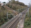
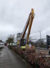
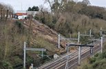
I went by this morning and there were a lot of vehicles and a large digger capable of reaching down the side of the cutting. They have taken over a car park next to the railway boundary and the closed off left hand lane of the road.

This is a deep part of the cutting and a different spot to the original landslip I think, but I wonder if inspections have identified other places where there are unstable sections that could slip.

PXL_20240319_122840445-1.jpgPXL_20240319_122347158-1.jpgPXL_20240319_122057050-1.jpgPXL_20240319_122651594-1.jpg

Here are a few photos taken today on the road and from the A4 bridge looking west. I'm not certain this is the site of the original landslip. It certainly looks a different place to the original photo that was published.
 
Last edited:

Benjwri

Established Member
Joined
16 Jan 2022
Messages
2,202
Location
Bath
I'm not certain this is the site of the original landslip. It certainly looks a different place to the original photo that was published.
I’m fairly certain it is the same place, I saw it from the same bridge after it happened. They’ve just cleared all the vegetation, which has made it look very different.
 

Skiddaw

Member
Joined
2 Jan 2020
Messages
229
Location
Penrith
I’m fairly certain it is the same place, I saw it from the same bridge after it happened. They’ve just cleared all the vegetation, which has made it look very different.
Yep- definitely. We used to live just down the road from there. I recognised the location in the original pic. Made me feel quite nostalgic!
 

Thames99

Member
Joined
11 Sep 2023
Messages
125
Location
Reading
They are really fortunate that access is so easy withg the car park providing access right by the railway boundary. There can't be many spots along the cutting where this is possible.

Maybe it is morre than coincidental that the landslip is here. Could it be that water has been draining from the tarmac onto the embankment during heavy rain which has destabilised the cutting?
 

800301

Member
Joined
29 Dec 2022
Messages
263
Location
Essex
I’m fairly certain it is the same place, I saw it from the same bridge after it happened. They’ve just cleared all the vegetation, which has made it look very different.

Yeah, that’s the one, although they have made it a lot more tidy, before the fence was up there was a 40ESR with a lookout, hopefully sorted now unless a lot more rainfall happens
 

PG

Established Member
Joined
12 Oct 2010
Messages
2,928
Location
at the end of the high and low roads
They are really fortunate that access is so easy withg the car park providing access right by the railway boundary. There can't be many spots along the cutting where this is possible.

Maybe it is morre than coincidental that the landslip is here. Could it be that water has been draining from the tarmac onto the embankment during heavy rain which has destabilised the cutting?
Makes you wonder if drainage/run-off onto existing infrastructure, e.g. the railway, forms any part of the planning process?
 

Benjwri

Established Member
Joined
16 Jan 2022
Messages
2,202
Location
Bath
Makes you wonder if drainage/run-off onto existing infrastructure, e.g. the railway, forms any part of the planning process?
Yes it absolutely does, although many developers overlook it where they see fit. However Network Rail will have been consulted on the development, and should have raised an objection to it on this basis.
 

PG

Established Member
Joined
12 Oct 2010
Messages
2,928
Location
at the end of the high and low roads
Yes it absolutely does, although many developers overlook it where they see fit. However Network Rail will have been consulted on the development, and should have raised an objection to it on this basis.
Therein lies the crux of the matter - Did NR (or its predecessors) raise any objections?

Incidentally am I the only one who wonders why a van purporting to be the Alaskan Malamute Sled Dog team is within the line of construction vehicles in @Thames99 photo?
 

Mark J

Member
Joined
12 May 2018
Messages
317
There is a partial road closure next to the cutting near the A4 bridge which is due to last some time. This link show the location:

I went by this morning and there were a lot of vehicles and a large digger capable of reaching down the side of the cutting. They have taken over a car park next to the railway boundary and the closed off left hand lane of the road.

This is a deep part of the cutting and a different spot to the original landslip I think, but I wonder if inspections have identified other places where there are unstable sections that could slip.

View attachment 154518View attachment 154519View attachment 154520View attachment 154521

Here are a few photos taken today on the road and from the A4 bridge looking west. I'm not certain this is the site of the original landslip. It certainly looks a different place to the original photo that was published.
I took the 850 to Henley the other day and wondered why the A4 at Shepherds House Hill was partially blocked off, with no apparent roadworks.

Now I know why!
 

Thames99

Member
Joined
11 Sep 2023
Messages
125
Location
Reading
I was passing this morning, so here is a photo of progress on the cutting at the site of the landslip. A lot of soil has been removed, but I was expecting to see a gabion wall being installed at the foot of the slope. Does anyone know if any work is proposed beyond reprofiling the slope?
 

Attachments

  • PXL_20240406_083623911.jpg
    PXL_20240406_083623911.jpg
    2.5 MB · Views: 166

Hellzapoppin

Member
Joined
16 Jan 2016
Messages
235
I think Sonning is predominantly clay and if so when it was first dug it will be well compacted, unlike many embankments. I don't think a gabion wall will be sufficiently robust enough to hold back a slip but if it is clay then I can't see any real need. I suspect it's the top soil which has slipped which is why it's been reprofiled. I wonder if some drainage will be included in the works though. Perhaps it will be at a later stage.
 
Last edited:

Thames99

Member
Joined
11 Sep 2023
Messages
125
Location
Reading
Wenzels and the dry cleaners at the other end of the car park being used for the works must have been quite badly affected. Although parking is possible in the car park in the centre of the roundabout, the entrance is on the other side opposite the pub. I imagine passing trade is well down, but Wenzels must be picking up some coffee and cake sales from the lorry drivers and workers on the site taking advantage of such a handy cafe.
 

Thames99

Member
Joined
11 Sep 2023
Messages
125
Location
Reading
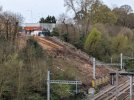
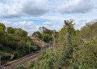
An update with photos from today. Work continues on the south side where the landslip occurred. sonning1.jpg

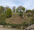
Directly opposite on the north side of the cutting undergrowth has been cleared and a chain saw gang was there this morning clearing the last few trees. It looks to me as if there has been some slumping of the surface and so work may also be needed there. Access will be much less straightforward there as I think there are gardens at the top of the embankment. sonning4.jpg
 

Wychwood93

Member
Joined
25 Jan 2018
Messages
648
Location
Burton. Dorset.
A couple of little bits for people to mull over. I have a book here: 'Brunel's Britain' by Derrick Beckett. ISBN 0 7153 7973 9. My copy dates from 1988 and pages 54-57 cover Sonning cutting. Figure 19 shows the deepest part of the cutting - which appears to be where the slip was. As built it was, of course, broad gauge and double track. As built the two running lines and the cesses had an overall width of 40' - it was then a horizontal distance of 90' on both sides with a slope up to 60' - overall cutting width 220'. This appears to give a slope of 1:3, some 33.3 degrees. The widening to four tracks completed by June 1893. See Wikipedia: https://en.wikipedia.org/wiki/Great_Western_Main_Line
It appears from a westward looking photo on page 56 that the widening clipped a few feet off of the base of the slope on either side with a retaining wall inserted. Some of the photos above show this. The way I look at it the angle of the slope remained the same. At the bottom of page 54 it says: "nearly two miles long at a depth varying from 20-60' through sand, clay and deep water."
 

DelW

Established Member
Joined
15 Jan 2015
Messages
4,169
A couple of little bits for people to mull over. I have a book here: 'Brunel's Britain' by Derrick Beckett. ISBN 0 7153 7973 9. My copy dates from 1988 and pages 54-57 cover Sonning cutting. Figure 19 shows the deepest part of the cutting - which appears to be where the slip was. As built it was, of course, broad gauge and double track. As built the two running lines and the cesses had an overall width of 40' - it was then a horizontal distance of 90' on both sides with a slope up to 60' - overall cutting width 220'. This appears to give a slope of 1:3, some 33.3 degrees. The widening to four tracks completed by June 1893. See Wikipedia: https://en.wikipedia.org/wiki/Great_Western_Main_Line
It appears from a westward looking photo on page 56 that the widening clipped a few feet off of the base of the slope on either side with a retaining wall inserted. Some of the photos above show this. The way I look at it the angle of the slope remained the same. At the bottom of page 54 it says: "nearly two miles long at a depth varying from 20-60' through sand, clay and deep water."
Ah, there's a name from the past - Derrick Beckett was one of my university lecturers half a century ago. He taught steelwork design and "architectural forms" if my memory is correct after so long!
I think there is a typo' in your slope calculation: 60' deep with a horizontal width of 90' is 1 : 1.5, not 1 : 3, but that does indeed give just over 33° to the horizontal. That's a steeper slope than would be used today other than in very good ground (which this appears not to be).
 

Wychwood93

Member
Joined
25 Jan 2018
Messages
648
Location
Burton. Dorset.
Ah, there's a name from the past - Derrick Beckett was one of my university lecturers half a century ago. He taught steelwork design and "architectural forms" if my memory is correct after so long!
I think there is a typo' in your slope calculation: 60' deep with a horizontal width of 90' is 1 : 1.5, not 1 : 3, but that does indeed give just over 33° to the horizontal. That's a steeper slope than would be used today other than in very good ground (which this appears not to be).
Thank you for the correction!
 

Jrocks

Member
Joined
27 Apr 2021
Messages
74
Location
Torbay
Looks like there has been another landslip in this location, however on the side of the Up Relief, anyone know anything more?
 

Wychwood93

Member
Joined
25 Jan 2018
Messages
648
Location
Burton. Dorset.
Last edited:

Top