Red Dragon
Member
The wall which collapsed might never have been intended to act as a retaining wall.
I've read the thread, looked closely at the various pics., and based on my experience I would suggest the investigations will centre on where the original ground levels were behind the wall, and where the levels were immediately before the collapse.
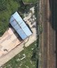
If you look at the photographs it looks very much like "made ground", in other words fill material may have been put against the stone wall to build up the ground level, a concrete slab put on top of the filled ground and then surcharged (loaded) with containers. This would have created a larger usable, level, storage area. It would also have put an unacceptable load onto the masonry wall potentially causing it to fail.
Look particularly at the photographs which show: -
1. What's left at the top of the cutting - this shows bits of black plastic in what looks like fill material, suggesting the fill is relatively new. Victorians didn't use black polythene.
2. The debris on the track, stone wall, fill material, and a concrete slab, which I guess was put on the fill to make a level base for the containers.
I'm not sure where the surface water running off the new concrete paved area was going - into the fill ?
If it was this would put even more pressure on the old stone wall.
Has there been much rainfall in the Liverpool area recently?
Oh dear, on the face of it, this looks as if it may have been a disaster just waiting to happen. But let's await the outcome of the investigation.
Fortunately nobody was injured.
I think they will need to do a lot of testing and checking on the cutting now one bit of it has failed - who says there won't be more? It's all quite old now.
The wall which collapsed might never have been intended to act as a retaining wall.
I need to ask your considered advice. I have a mate going to London on Sunday 5 March on the 9am Virgin from Preston, and returning to Lime Street on Monday 6 at 10:20am.
She doesn't like disruption. Do you think I could/should change the ticket for a return to Preston?
Dunno what to do.
Thanks
That rules out everything except 142s and 150s.
Looking at the photos it looks like a landslip that wasn't held by the retaining wall of the cutting. Wasn't there an RAIB report a few years ago about a (much smaller) retaining wall failing in a similar manner? Also I think there was one where changes in adjacent land use had not been understood leading to overloading of the railway's drainage systems and consequent embankment failure. Both I think led to recommendations to NWR to learn about and ensure their retaining walls and embankments were in a fit state.
It seems here that the adjacent land use seems to have come as a surprise to the railway, when surely that should never been the case?
If the track furthest can be cleared, does the track layout of Lime Street allow all platforms to access that track, to allow a diesel to move any trains that are trapped out of the station?
Looking on the Railcam diagram, yes the furthest line from the collapse can connect with ALL platforms at Liverpool
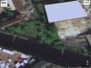
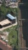
I've attached the google earth historical imagery for the site - it looks to have been developed' around 2004, and hasn't changed much since.
(And it was extremely wet at the time)
If the track furthest can be cleared, does the track layout of Lime Street allow all platforms to access that track, to allow a diesel to move any trains that are trapped out of the station?
I'm not sure where the surface water running off the new concrete paved area was going - into the fill ?
If it was this would put even more pressure on the old stone wall.
Has there been much rainfall in the Liverpool area recently?.
I've attached the google earth historical imagery for the site - it looks to have been developed' around 2004, and hasn't changed much since.
(And it was extremely wet at the time)
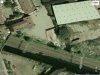
Comparing the 2012 and 2016 pictures it would appear that a bulge has arisen in the wall between those dates.
I've attached the google earth historical imagery for the site - it looks to have been developed' around 2004, and hasn't changed much since.
(And it was extremely wet at the time)
There was a lot of heavy rain fall in the afternoon just prior to this incident.
Was the main new headline on BBC North West Today, where they have started the cannot be sure if the third party containers were to blame. Also stated 40 tonnes of debris did come onto the track
Interesting how very quickly NR were to lay the blame firmly and squarely on the third party before a full investigation has taken place - which may (or may not) identify other contributing factors, e.g. integrity/maintenance of the retaining wall (which I'm guessing is theirs), impact of the subterranean tunnels which are there, assessment of lineside risks following RAIB findings into previous incidents etc.
I'm not saying Network Rail are at all to blame - just find it intriguing how quickly and adamantly they've pointed the finger prior to the full facts being established.
Mentioned on another site 5 x 319s are stuck where they are as a result of the collapse. Not sure if it's been posted on here or not.
I've attached the google earth historical imagery for the site - it looks to have been developed' around 2004, and hasn't changed much since.
(And it was extremely wet at the time)
Indeed. If you have an apple device, look at apple maps in 3D. The bulge is visible there and also what looks like a crack in the concrete slab. Not sure of the date as Apple maps doesn't show a date like Google does.Comparing the 2012 and 2016 pictures it would appear that a bulge has arisen in the wall between those dates.
Wow, it does, doesn't it?
Does this call into question, once again, Network Rail's management of its property?
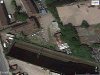
Good find. Looking at the Google Ariel photo of that same point, is it just my eyes or does the wall look slightly buckled at that point before the collapse.
Dropped pin
https://goo.gl/maps/r1AEmNUEsqy
Comparing the 2012 and 2016 pictures it would appear that a bulge has arisen in the wall between those dates.