jfuller595@gma
Member
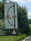
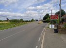
Stonea Railway Crossing on the Sixteen Foot Bank, Stonea (Cambs)
The bridge here holds the dubious title of the 'Most Struck Bridge in Britain' with 33 strikes last year (although the real figure is much higher)
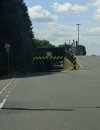
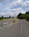
The other concern is the road layout. Vehicles too tall to go under the 6'6" bridge have to leave the main carriageway and go over the crossing itself.
Vehicles frequently go over the crossing, neglect to stop and look before merging back onto the carriageway resulting in smashes. There was sadly a death here some months ago.
To make matters more complicated, the crossing gate is manually controlled.
Despite the frequent bridge strikes and accidents around the bridge, Network Rail and Cambridgeshire Council have stated that they cannot close the underpass until the crossing itself is upgraded to automatic barriers. Network Rail and the Council have said that this location is not deemed dangerous enough to warrant further investment and that upgrades to the barriers will cost millions
Network Rail claim that it is too dangerous to close the underpass while there are manual gates due to the volume of traffic going over the crossing.
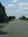
Other ideas, such as a reduction in speed limit around this location have been refused. It is currently a 50mph limit despite the underpass not being wide enough to accommodate two cars.
The residents are at a loss as to what to do. They claim the bridge is struck on average twice a week and the road layout makes it unsafe coming on and off of their driveways.
Is anyone aware of other locations like this one? I'm not aware of one myself.
The bridge here holds the dubious title of the 'Most Struck Bridge in Britain' with 33 strikes last year (although the real figure is much higher)
The other concern is the road layout. Vehicles too tall to go under the 6'6" bridge have to leave the main carriageway and go over the crossing itself.
Vehicles frequently go over the crossing, neglect to stop and look before merging back onto the carriageway resulting in smashes. There was sadly a death here some months ago.
To make matters more complicated, the crossing gate is manually controlled.
Despite the frequent bridge strikes and accidents around the bridge, Network Rail and Cambridgeshire Council have stated that they cannot close the underpass until the crossing itself is upgraded to automatic barriers. Network Rail and the Council have said that this location is not deemed dangerous enough to warrant further investment and that upgrades to the barriers will cost millions
Network Rail claim that it is too dangerous to close the underpass while there are manual gates due to the volume of traffic going over the crossing.
Other ideas, such as a reduction in speed limit around this location have been refused. It is currently a 50mph limit despite the underpass not being wide enough to accommodate two cars.
The residents are at a loss as to what to do. They claim the bridge is struck on average twice a week and the road layout makes it unsafe coming on and off of their driveways.
Is anyone aware of other locations like this one? I'm not aware of one myself.