• Our booking engine at tickets.railforums.co.uk (powered by TrainSplit) helps support the running of the forum with every ticket purchase! Find out more and ask any questions/give us feedback in this thread!

M61 Rail bridge

Status
Not open for further replies.

Dawg

Member
Joined
28 Jan 2014
Messages
57
The old manchester collieries rail bridge that spans the M61 just as the motorway splits to the A666, A580 and M60

Was this ever used? Closure of the collliery network happened before the motorway system fully opened? Or have I got that wrong?

It linked to the extensive sidings at Kearsley - I vaguely remember those..,


Anyone give some info about it? If it was ever seriously used; What locos ran over it? B.R or N.C.B?
 
Sponsor Post - registered members do not see these adverts; click here to register, or click here to log in
R

RailUK Forums

table38

Established Member
Joined
12 Oct 2010
Messages
1,812
Location
Stalybridge
I can't help with the history, but I do have a map!

This was the L&Y Kearsley No.1 Brach down to the Bridgewater Canal. I suspect it was used to get coal from the Bridgewater pits to the Kearsley Power Station (which had a rather nice 550v DC Electric Network). Now that closed in 1981 and was demolished in 1985. But the M61 was started in 1969, so hence (I guess) the bridge!

Some pictures of the old line here: http://www.bikerides.dsracing.me.uk/railway/kearsley.htm

Picture of the electrics here: https://www.flickr.com/photos/28083135@N06/5549789398/

The sort of steam loco used on the branch I believe were things like the Kerr Stuart one pictured here: http://www.ebay.co.uk/itm/Industrial-Steam-Loco-Wheatsheaf-Colliery-Kearsley-KS-3123-18-1959-Photo-/371008015704?nma=true&si=VQ4R628rfAFWwJWCb75mX%252BvqVXg%253D&orig_cvip=true&rt=nc&_trksid=p2047675.l2557. These were owned and operated by Bridgewater Collieries Ltd

(The electric network was only around the power station and the exchange sidings, so did not run over the M61 bridge. The site was used later by GEC for tram research)
 

Attachments

  • kearsley.jpg
    kearsley.jpg
    147.5 KB · Views: 114
  • kearsley2.jpg
    kearsley2.jpg
    142 KB · Views: 105
Last edited:

Dawg

Member
Joined
28 Jan 2014
Messages
57
I've searched for photos of the line in situ - absolutely nothing. I don't think it was being used after the '70's (or even during most of that decade)

It's a serious structure though - enough for double track..
 

Darren R

Established Member
Joined
26 Jan 2013
Messages
1,252
Location
Lancashire
The Kearsley branch was opened on 28th February 1878, constructed to connect with the Bridgewater Collieries. Originally there were two branches: No2 Branch (the northernmost on the map in table38's post) was the shorter of the two and served what my reference book calls Stony Hill Colliery - although it's referenced as Stonehill Colliery on table38's map. This opened at the same time, but only lasted a decade before the closure of the coal workings rendered the line redundant.

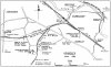
No1 branch provided a connection on Linnyshaw Moss (just south east of the M61/A666 junction) with the Bridgewater Collieries Railway by means of extensive exchange sidings. The branch was originally double track from Kearsley Junction, where there were sidings on the Down side opposite Kearsley signal box. Additionally, until the line was singled in 1930, there was another signal box, Kearsley Branch Sidings, which controlled movements on the branch from a 12 lever frame. This box closed around the time the branch was singled, and was replaced by a ground frame which controlled movements to and from the branch. The bottom end of the branch retained two tracks (not sure how far up this continued, but it was single track by the time it passed Roscow Road level crossing on the north-eastern side of Bolton Road at the top of Stoneclough Road), with the southernmost track being used as a headshunt for the sidings at Kearsley Junction.

The sidings at Kearsley Junction were enlarged and a short branch down to the Lancashire Electric Power Company's Kearsley Power Station was laid in 1927. This branch and some of the sidings were electrified.

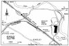
BR locomotives were only permitted as far as Linnyshaw Moss Sidings Frame at the summit of the line, where the colliery engines took over. Linnyshaw Moss Sidings were closed to traffic on 26th June 1966 and the connection to the colliery removed. The remainder of the branch closed north of Kearsley Branch Sidings on 15th August 1971, but the sidings and a short headshunt remained in use until the power station branch closed in 1977.

So the bridge over the M61/A666 would only have had an 'operational' railway line upon it for eight months - but given that the link to the colliery and exchange sidings were already closed by the time the motorway opened, it seems doubtful if the bridge was ever actually used by anything other than the track recovery train! As to why the bridge is so substantial; I can't answer that. It certainly looks like it is double track, but it hadn't been a double track railway at that point for 40 years. The bridge is two seperate spans - perhaps one carried the railway and the other a footpath or similar track?
 

Sox

Member
Joined
22 Oct 2010
Messages
265
OS 1:25000 mapping appears to show a public footpath on the west half of the bridge:

http://www.streetmap.co.uk/map.srf?X=374342&Y=404140&A=Y&Z=115

Google satellite view and old-maps.co.uk seem consistent with that.

The year 2000 version (Historical Imagery) of Google Earth shows work being carried out on the bridge.

Has as been said, the bridge seems a big deal for its original limited function. Maybe it is/was also used to carry HV cables or other services?
 
Last edited:

Dawg

Member
Joined
28 Jan 2014
Messages
57
It does seem after some enquiry that it was only operational for 8 months - such an odd decision considering the Manchester Colliery network was shut down and being dismantled elsewhere..

Yet the decisions were made to shut the trunkated Chequerbent - Bolton line instead of building a bridge in 1969ish; I believe it was being used right up to the earthworks starting for the M61 - and the Eccles - Tyldesley line for the M602... ( a line that should never have closed! )
 

snowball

Established Member
Joined
4 Mar 2013
Messages
7,745
Location
Leeds
I've dug out an old 1:25000 Second Series map, major roads revised 1971, which shows the railway occupying the eastern half of the bridge, as speculated above.
 
Status
Not open for further replies.

Top