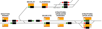
The diagram on Traksy around Stratford-upon-Avon (https://traksy.uk/live/M+31+SOAV+-10) has been confusing me. The position of the signal berths makes it look like if a path is set for a train out of platform 1 at Stratford, then approaching trains from the north can't even proceed into Wilmcote until it has left, which would seem excessively restrictive and contradict the timetable in some cases. Where is the last approach signal really positioned, and can a train towards Statford call at Wilmcote and/or Stratford Parkway while a route is set out of Stratford platform 1?
Attached: Screenshot from Traksy showing the area around Stratford-upon-Avon
Attached: Screenshot from Traksy showing the area around Stratford-upon-Avon
Attachments
Last edited: