The met office have named Storm Doris for Thursday currently, the worst affected areas are expected to be the East Midlands, East of England, North West England, Wales, West Midlands, Yorkshire & Humber where winds could hit 80mph for a short time
The exact track of the storm isn't final yet as such the exact areas which will be worst affected is still subject to change
With high wind speeds, disruption to rail services is entirely possible from fallen trees etc
If you are planning on traveling on Thursday you would be advised to check the forecast and be prepared for last minute changes
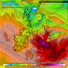
The current estimate for the worst of the winds is in the amber warning below

The exact track of the storm isn't final yet as such the exact areas which will be worst affected is still subject to change
With high wind speeds, disruption to rail services is entirely possible from fallen trees etc
If you are planning on traveling on Thursday you would be advised to check the forecast and be prepared for last minute changes
The current estimate for the worst of the winds is in the amber warning below
Last edited:

")


