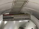
Up until the refurbishment Anderston just had, there was SPT signage opposite the Partick bound platform, also attached a photo of that
I distinctly recall something similar being partially uncovered a good few years ago (September 2014 at the earliest) on the same line, one station to the east at Glasgow Central Low Level, also on the Partick-bound platform. IIRC, that was the 'SPT Rail' era branding as opposed to the SPT 'flash'-era iteration at Anderston.
At Glasgow Queen Street Low Level earlier the same year during refurbishment works (image attached below,
from scotrail.co.uk) a map dating from the late 70s at the latest was uncovered. Partick is off-center to it's bulletpoint and Yoker has a (High) in parentheses, meaning this is an original, pre-1965 'Blue Train' map tweaked to reflect the Argyle Line opening & the closure of Partickhill in late 1979. I think it was covered up again as opposed to being removed outright. What was uncovered was/is still fairly accurate to the present North Clyde network west of Queen Street (barring Yoker (High) ofc). No doubt if it were fully uncovered, the westernmost extremity of the Balloch branch, as it was in the 60s when this map was current, would've raised a few eyebrows.