• Our booking engine at tickets.railforums.co.uk (powered by TrainSplit) helps support the running of the forum with every ticket purchase! Find out more and ask any questions/give us feedback in this thread!

Unused Infrastructure around New Malden Junction

Status
Not open for further replies.
Joined
17 Feb 2016
Messages
93
The area around New Malden Junction contains various piece of redundant railway infrastructure which aren't shown on any old maps to have ever accommodate a track.
The first is the diveunder at the junction itself, which has an extra bore to accommodate a track diverging from the Up Kingston and heading for the downside of the main line.
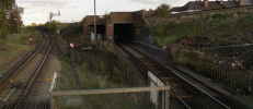
1690309978162.png
It would seem as though it was built to connect to the slow side before the flyover was built at Wimbledon. Before the flyover was built, however, the Up slow cross the fasts on the flat somewhere in the vicinity of Clapham Junction, and this section has always been direction-grouped, and Raynes Park station is laid out accordingly. The oldest map I can find, from the 1890s, shows the junction with exactly the same layout as it has presently, including the underpass being wide enough for two tracks though accommodating only one.
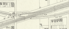
1690310368648.png
Also of notable on the above map is the wide strip of railside land beginning at Elm Road and extending to the east.
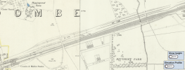
1690311112625.png
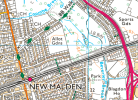
This parallels the railway all the way to West Barnes Lane. What's unusual about it is that someone's actually gone to the trouble of levelling this strip of land from end to end, as though it was intended to put tracks on it. All maps I can find show it in the same state it is in currently. The only thing I can think is that this must be the undertaking of the ill-fated Guildford, Kingston & London Railway. Today it has been put to use for a cycle route, taking advantage of the convenient cutting through Malden Hill and crossing of the Beverley Vale. This is the profile of where the strip of land cuts through. The strip itself is, of course, flat.
1690311705841.png
 
Sponsor Post - registered members do not see these adverts; click here to register, or click here to log in
R

RailUK Forums

Sad Sprinter

Established Member
Joined
5 Jun 2017
Messages
1,829
Location
Way on down South London town
The area around New Malden Junction contains various piece of redundant railway infrastructure which aren't shown on any old maps to have ever accommodate a track.
The first is the diveunder at the junction itself, which has an extra bore to accommodate a track diverging from the Up Kingston and heading for the downside of the main line.
View attachment 139715
It would seem as though it was built to connect to the slow side before the flyover was built at Wimbledon. Before the flyover was built, however, the Up slow cross the fasts on the flat somewhere in the vicinity of Clapham Junction, and this section has always been direction-grouped, and Raynes Park station is laid out accordingly. The oldest map I can find, from the 1890s, shows the junction with exactly the same layout as it has presently, including the underpass being wide enough for two tracks though accommodating only one.
View attachment 139716
Also of notable on the above map is the wide strip of railside land beginning at Elm Road and extending to the east.
View attachment 139720
This parallels the railway all the way to West Barnes Lane. What's unusual about it is that someone's actually gone to the trouble of levelling this strip of land from end to end, as though it was intended to put tracks on it. All maps I can find show it in the same state it is in currently. The only thing I can think is that this must be the undertaking of the ill-fated Guildford, Kingston & London Railway. Today it has been put to use for a cycle route, taking advantage of the convenient cutting through Malden Hill and crossing of the Beverley Vale. This is the profile of where the strip of land cuts through. The strip itself is, of course, flat.
View attachment 139721

I would have said it was going to be used for pre-WW1 six tracking, but as the map is from 1890 I'm not sure. I do think that the unused bridge spans at the junction are for extra rails that led onto the Wimbledon to Tooting line, for LSWR's services to Ludgate
 

stuving

Member
Joined
26 Jan 2017
Messages
266
According to Wikipedia on the LSWR:
In 1869 the Kingston loop line was completed by the south-eastward extension from Kingston to Wimbledon, with its own dedicated track alongside the main line from Malden to Epsom Junction (Raynes Park), where it joined the former Wimbledon and Dorking Railway lines.
That strip north of the main line does indeed run all the way to Raynes Park, so would fit the description.
 

swt_passenger

Veteran Member
Joined
7 Apr 2010
Messages
31,447
In the Middleton Press book on Waterloo to Woking they mention in the text, (paragraph 74), that the up route through the diveunder was opened in 1884, so it must have had a very short life, as the paired by direction layout is shown in place on the next page of the book, their track layout being included on a map extract the same as the 1892-1914 series of 25” maps on the NLS site - I expect that’s the source for the OP’s first map.

The NLS state that sheet was revised 1895 and published 1897. The Middleton Press authors also date the map extract in the book as being from 1897.

So I’d suggest about a maximum possible 10 or 11 year use, 1884-1895.
 
Last edited:
Joined
17 Feb 2016
Messages
93
According to Wikipedia on the LSWR:

That strip north of the main line does indeed run all the way to Raynes Park, so would fit the description.
When the Kingston branch was a separate parallel line between Malden and Wimbledon, it was on the south side of the mainline, so this would not explain the earthworks to the north. It also does not explain why the diveunder has room for 2 tracks, because when it did this, the mainline was only 2-track, and it is a 4-track underbridge.
Wikipedia also says that there was a 2-year period from 1882 to 1884 when the mainline to Surbiton was quadrupled but the spur ending the Up Kingston hadn't been completed yet, implying a temporary arrangement whereunder Up trains ran through the now-obsolete tunnel, before crossing back over the entire alignment to reach platform 1.
 

stuving

Member
Joined
26 Jan 2017
Messages
266
The 6" maps show this feature running west past the Kingston branch and then diverging, and the 1866/71 map labels it "Lambeth Water Works". Apparently their pipe started from Seething Wells, and later upstream at Molesey. However, it looks as if the works were in some way coupled with the railway, perhaps just by both going the same way at about the same time and so deciding to join forces. The strip of land water pipes were laid in usually had to be kept clear for access in case of repair, so this could have dictated where the Kingston-Wimbledon line was put and where the extra tracks for quadrupling could go.

The earlier 6" map also shows the parallel Kingston branch as twin track, and the later 25" map shows the space the second track occupied, though not the shape of the new underpasses - it still looks like a skew bridge.

The transitional arrangements during quadrupling would impose other constraints. If the new chord was not built first, the two new tracks would need to be built over the two Kingston tracks while they were in use. So half of the second underpass would need to be there at the beginning. I guess you could just leave it like that, but if the new chord was still not ready then the old bridge would have to replaced by the second half of the two new underpasses.

I imagine this kind of quadrupling proceeded by building the new tracks and civils first, then putting in all the new points to make the new paths possible. So there could be quite a long period of transitional arrangements. Mind you, these Victorians didn't always do things how I'd expect, and they might have used a big bang approach instead.
 
Last edited:

gravitystorm

Member
Joined
25 Nov 2021
Messages
32
Location
Motspur Park
What's unusual about it is that someone's actually gone to the trouble of levelling this strip of land from end to end, as though it was intended to put tracks on it.
It's a common misconception (that I shared too!) that this is a railway cutting, but it's not and has never been. Instead, it's one of the main water supply routes for south west London, and under the surface are multiple large-bore high pressure main water pipes. You can trace their route roughly parallel to the railway for some distance, due to the lack of any substantial buildings over the top - until recently they were ancient cast iron pipes at a remarkably shallow depth, and the formation was not particularly load bearing without putting the pipes at risk. The new cycle track from New Malden to Raynes Park had to wait for Thames Water to 'reline' their pipes (by inserting plastic ones inside the originals, which can take a higher pressure to counteract having a smaller bore) before the path could be constructed. This article has more details: https://waterprojectsonline.com/custom_case_study/new-malden-trunk-mains/

You can easily trace this part of the pipe route, when you know what you are looking for! From near the Hogsmill River, 1km further down the SW mainline, there is a line of allotments, footpaths, unused land, car parks for light industry, i.e. nothing weighty built on top of these pipes. They then continue from where that photo was taken alongside the railway to Raynes Park, curve through the Waitrose car park to avoid the Up line from Motspur Park, and are the real reason for the substantial "Skew" underpass at Raynes Park station - sadly not constructed just for pedestrians and cyclists! They continue under Kingston Road, and the final obvious stretch is where they pass under the Sutton Loop just north of Wimbledon Chase station, again on a wide flat formation with a bike path and substantial railway overbridge, that makes the alignment look like it's a disused railway line.

If you visit the New Malden junction, and stand roughly where the photo was taken, and crane your neck a bit, you can see the pipes emerging from under the level crossing, and disappearing again under the path. It's also why both of the lines shown in the foreground are on "ground level bridges", the bridges are spanning across the pipes to avoid any load on them.
 

Sad Sprinter

Established Member
Joined
5 Jun 2017
Messages
1,829
Location
Way on down South London town
It's a common misconception (that I shared too!) that this is a railway cutting, but it's not and has never been. Instead, it's one of the main water supply routes for south west London, and under the surface are multiple large-bore high pressure main water pipes. You can trace their route roughly parallel to the railway for some distance, due to the lack of any substantial buildings over the top - until recently they were ancient cast iron pipes at a remarkably shallow depth, and the formation was not particularly load bearing without putting the pipes at risk. The new cycle track from New Malden to Raynes Park had to wait for Thames Water to 'reline' their pipes (by inserting plastic ones inside the originals, which can take a higher pressure to counteract having a smaller bore) before the path could be constructed. This article has more details: https://waterprojectsonline.com/custom_case_study/new-malden-trunk-mains/

You can easily trace this part of the pipe route, when you know what you are looking for! From near the Hogsmill River, 1km further down the SW mainline, there is a line of allotments, footpaths, unused land, car parks for light industry, i.e. nothing weighty built on top of these pipes. They then continue from where that photo was taken alongside the railway to Raynes Park, curve through the Waitrose car park to avoid the Up line from Motspur Park, and are the real reason for the substantial "Skew" underpass at Raynes Park station - sadly not constructed just for pedestrians and cyclists! They continue under Kingston Road, and the final obvious stretch is where they pass under the Sutton Loop just north of Wimbledon Chase station, again on a wide flat formation with a bike path and substantial railway overbridge, that makes the alignment look like it's a disused railway line.

If you visit the New Malden junction, and stand roughly where the photo was taken, and crane your neck a bit, you can see the pipes emerging from under the level crossing, and disappearing again under the path. It's also why both of the lines shown in the foreground are on "ground level bridges", the bridges are spanning across the pipes to avoid any load on them.

Amazing, thanks for the explanation.

I was just going to say the Southern Region seems full of oddities like the alignment identified in this thread. There is still the mystery of the unused bridge spans just west of the sidings between Balham and Streatham Hill, but I suppose the amount of mysterious supposedly unused pieces of infrastructure has diminished by exactly one.
 

swt_passenger

Veteran Member
Joined
7 Apr 2010
Messages
31,447
It's a common misconception (that I shared too!) that this is a railway cutting, but it's not and has never been. Instead, it's one of the main water supply routes for south west London, and under the surface are multiple large-bore high pressure main water pipes. You can trace their route roughly parallel to the railway for some distance, due to the lack of any substantial buildings over the top - until recently they were ancient cast iron pipes at a remarkably shallow depth, and the formation was not particularly load bearing without putting the pipes at risk. The new cycle track from New Malden to Raynes Park had to wait for Thames Water to 'reline' their pipes (by inserting plastic ones inside the originals, which can take a higher pressure to counteract having a smaller bore) before the path could be constructed. This article has more details: https://waterprojectsonline.com/custom_case_study/new-malden-trunk-mains/
Thanks, very interesting. That project’s worksite at the Raynes Park end of the run is currently visible on Google Streetview, a significant hoarded off area labelled “Making Pipes Stronger” at the southeast corner of the sports ground near Taunton Ave.
 

Snow1964

Established Member
Joined
7 Oct 2019
Messages
6,257
Location
West Wiltshire
Originally the Kingston loop was built from the Twickenham end. The connecting line from Wimbledon to Kingston ran alongside the then 2 track mainline (branching off the old Tooting loop) and both tracks dived under. Ever since the rearrangment of tracks as part of the quadrupling the second dive under became redundant. It was extended when widened to 4 tracks towards Surbiton.

The strip of land alongside to Raynes Park contains water mains, it passes under the line near Raynes Park and then continues other side of line.

I think all the bridges between New Malden and Raynes Park were widened for the 6 tracking around 1910-1915 (although couple of underbridges didn't get their decks, but abutments were done)

100 years ago (in 1923) Kingston bypass was started, and the bridge over rail line had extra spans for the 5th and 6th track. The bypass opened in 1927 (along with the Merton spur, now A298)

Berrylands station was only added in October 1933

The two rail bridges over the road at New Malden were replaced about 1960, at the time the signal box (now demolished) was just across the bridge and one of the bridges has a very narrow walkway from the island platform to access the former signal box.

New Malden station never had a goods yard, instead there was a yard the other side of Elm Road level crossing (where the industrial units in Wellington Crescent are now).
 

stuving

Member
Joined
26 Jan 2017
Messages
266
I now realise I did know about that water main already, though "did know" does not imply "can recall". It came up a few years ago in another forum, where we'd been working out the route of what must be the biggest of these pipe-tracks, the Metropolitan Water Board's one from Kempton (Hampton, Molesey, Walton, etc.), around London to Fortis Green (Muswell Hill).

That was completed in around 1910, though much was built by local boards before the MWB was set up (1903). It ran mostly across fields, which were soon being covered with houses. But almost all of that route can still be identified, once you know what to look for, and some of it really does look like an ex-railway.
 

DelW

Established Member
Joined
15 Jan 2015
Messages
3,884
I now realise I did know about that water main already, though "did know" does not imply "can recall". It came up a few years ago in another forum, where we'd been working out the route of what must be the biggest of these pipe-tracks, the Metropolitan Water Board's one from Kempton (Hampton, Molesey, Walton, etc.), around London to Fortis Green (Muswell Hill).

That was completed in around 1910, though much was built by local boards before the MWB was set up (1903). It ran mostly across fields, which were soon being covered with houses. But almost all of that route can still be identified, once you know what to look for, and some of it really does look like an ex-railway.
I remember researching that one about twenty years ago. I used to fly into Heathrow quite frequently, and when landing from the east and sitting on the right, I'd seen the alignment cutting diagonally across a rectangular grid of suburban roads. I eventually tracked it from Kempton to Dollis Hill, but I hadn't spotted the continuation to Fortis Green, I'll have to have a look for that!
 

Basil Jet

On Moderation
Joined
23 Apr 2022
Messages
985
Location
London
I remember researching that one about twenty years ago. I used to fly into Heathrow quite frequently, and when landing from the east and sitting on the right, I'd seen the alignment cutting diagonally across a rectangular grid of suburban roads. I eventually tracked it from Kempton to Dollis Hill, but I hadn't spotted the continuation to Fortis Green, I'll have to have a look for that!
It passes just north of Golders Green station, and there is an old pump house here (the little hut with 3 camera signs on it) with fascinating antiquated machinery visible through the windows.
 

stuving

Member
Joined
26 Jan 2017
Messages
266
It passes just north of Golders Green station, and there is an old pump house here (the little hut with 3 camera signs on it) with fascinating antiquated machinery visible through the windows.
Those things were usually labelled "valve house" - a pump for this class of main was a massive thing. This one was not labelled on the 1912 maps, but is on the ca. 1949 1:1250 map. These still show the (often oblique) boundary lines, and the marker posts, that show the pipe's route. And in glorious close-up!

Most of the route from the Cricklewood reservoir and pumping station to the Fortis Hill reservoir is along Temple Way and The Vale.
 
Last edited:

Basil Jet

On Moderation
Joined
23 Apr 2022
Messages
985
Location
London
"valve house" -
Thanks, it's not something I know a lot about.

Most of the route from the Cricklewood reservoir and pumping station to the Fortis Hill reservoir is along Temple Way and The Vale.
The other bits people might find interesting are that

The Northern Line south of East Finchley has its own bridge over the pipeline visible if you go behind a car showroom

There is a distinctive type of fence wherever the alignment meets a road. The same type of fence can be seen where the underground part of the New River in Enfleld Town meets roads or footpaths.

[This view] shows how the pipeline emerging from the end of Conduit Way (name significant) in Stonebridge Park passes between the two curved towers of the former Honeywell Bull HQ and was responsible for that design.

It passes in front of the Hoovers Building in Perivale and is the reason that it is set back from the A40.
 

seaviewer

Member
Joined
3 Aug 2018
Messages
57
Amazing, thanks for the explanation.

I was just going to say the Southern Region seems full of oddities like the alignment identified in this thread. There is still the mystery of the unused bridge spans just west of the sidings between Balham and Streatham Hill, but I suppose the amount of mysterious supposedly unused pieces of infrastructure has diminished by exactly one.
I have noticed this - does anyone know about the unused spans?
 

MotCO

Established Member
Joined
25 Aug 2014
Messages
4,135
If you visit the New Malden junction, and stand roughly where the photo was taken, and crane your neck a bit, you can see the pipes emerging from under the level crossing, and disappearing again under the path. It's also why both of the lines shown in the foreground are on "ground level bridges", the bridges are spanning across the pipes to avoid any load on them.

One evening in November 1997, I was travelling from Norbiton to Waterloo, and we came to a stop just before New Malden station. After some time, the driver walked through the train so I asked him what the problem was. Flooding at Elm Road was the answer, so the train was reversing and going to Waterloo the other way. (I decided to get off at Norbiton and catch the 213 to New Malden, and catch a train to Waterloo - I wonder whether this was the quicker route?)

Now I know why there was flooding!
 

sharpener

Member
Joined
4 Oct 2018
Messages
33
Instead, it's one of the main water supply routes for south west London, and under the surface are multiple large-bore high pressure main water pipes.

I grew up in New Malden and went to Elm Road school but have to say I don't remember the disused underpass bore. I used to play with my friends on the Golf Course between Cambridge Avenue and the rly, IIRC there were two 36 in pipes which were very visible where they and the rly cross Beverley Brook at high level. The alignment from there to NM station was shown on my parents' road atlas as "Metropolitan Water Board Pipe Track" so I was never in any doubt as to what they were.

We also used to watch the trains from the footbridge between Alric Avenue and Dukes Avenue, the braver ones among us sitting or standing on the capstones the better to wave at the drivers who always waved back. Headcodes I remember were H or 30 for Hampton Court, V or 61 for Richmond and S or 24 for Shepperton but the Merchant Navy class loco-hauled trains were much more impressive.

1691267819945.png
 

MotCO

Established Member
Joined
25 Aug 2014
Messages
4,135
We also used to watch the trains from the footbridge between Alric Avenue and Dukes Avenue, the braver ones among us sitting or standing on the capstones the better to wave at the drivers who always waved back. Headcodes I remember were H or 30 for Hampton Court, V or 61 for Richmond and S or 24 for Shepperton but the Merchant Navy class loco-hauled trains were much more impressive.


The headcodes for the Richmond (to Waterloo) trains was 32 if I recall correctly, and 21 coming from Richmond from Waterloo on the loop.

(One of my best friends lived in Alric Avenue.)
 

alf

On Moderation
Joined
1 Mar 2021
Messages
356
Location
Bournemouth
And headcode 68 for Waterloo, Richmond to Kingston 4 or 8 car trains terminating in the down side bay at Kingston every half hour in those days.
The bay hasn’t been extended for the relatively new 10 car trains, despite there being space, so it is in practise out of use.
 

AY1975

Established Member
Joined
14 Dec 2016
Messages
1,760

30907

Veteran Member
Joined
30 Sep 2012
Messages
18,081
Location
Airedale
Not sure if this belongs in this thread, but as I mentioned in entry #97 on page 4 of the now locked thread on stations with too many platforms at https://www.railforums.co.uk/threads/trivia-stations-with-too-many-platforms.217785/page-4 the central island platform at New Malden has never been used, or at least never been in regular use, for as long as I can remember. Does anyone know when it was last used, and which services called there?
Nothing shows in the 1959 WTT; the only long distance service that called there was a Milk Train at 1.33am (why?) and that is shown as Local Line.
The facilities on the island platform appear rather modest on the 30s OS map too.
My guess is that there were no booked trains from the completion of the main line electrification in 1937 and not many before that - but it was certainly used at times during engineering works and emergencies.

Edit: see later post.
 
Last edited:

norbitonflyer

Established Member
Joined
24 Mar 2020
Messages
2,407
Location
SW London
And headcode 68 for Waterloo, Richmond to Kingston 4 or 8 car trains terminating in the down side bay at Kingston every half hour in those days.
The bay hasn’t been extended for the relatively new 10 car trains, despite there being space, so it is in practise out of use.
There isn't space, at least not witghout demolishing some of the station buildings beyond the buffer stops, or moving the convergence poiunt between the bay platform line and the Twickenham -bound line further west, which would mean replacing the bridge over the ring road with a wider one.

Even when if the 701s eneter service, the bay platfrom (1) can still be used by 5-car sets, which is really all that is needed for a Shepperton shuttle. But through Platform 2 was resignalled a few years ago to allow 10-car trains to reverse there. (At the same time that platform 3 was extended across the Richmond Road bridge)
 

Snow1964

Established Member
Joined
7 Oct 2019
Messages
6,257
Location
West Wiltshire
There isn't space, at least not witghout demolishing some of the station buildings beyond the buffer stops, or moving the convergence poiunt between the bay platform line and the Twickenham -bound line further west, which would mean replacing the bridge over the ring road with a wider one.
Not quite correct, the bay platform extends over the ring road bridge. The next bridge west (over Skerne Road) also has space for third track (there was goods siding in the past), it would be possible to slew the up track over this thus allowing the line from platform 2 to be moved over too, which would allow the bay platform to be extended about 45m for 10car trains.

Just a bit costly to do. That's why when 10car scheme was being developed was serious consideration of putting in reversing spur at New Malden side of Norbiton instead. There used to be a long siding and still is empty arch under Gloucester Road bridge. It would have been (and still is) possible to slew line onto course of old siding, leaving a central reversing siding (where current track is). Because of the bridge pier (Gloucester Road) tracks would have to be spaced further apart so could have a walkway for short length which could be used if two 5car 701s were coupled, preventing driver walking through the whole train. However this enhancement got dropped as allowing reversal at platform 2 in Kingston was cheaper.
 

MotCO

Established Member
Joined
25 Aug 2014
Messages
4,135
Not sure if this belongs in this thread, but as I mentioned in entry #97 on page 4 of the now locked thread on stations with too many platforms at https://www.railforums.co.uk/threads/trivia-stations-with-too-many-platforms.217785/page-4 the central island platform at New Malden has never been used, or at least never been in regular use, for as long as I can remember. Does anyone know when it was last used, and which services called there?

My parents used to commute from New Malden from 1954, and I'm sure they used to catch a fast train (steam of course!) and for some reason had assumed it ran from Platform 2 (the island platform). For 'fast' I assume it did not stop at Raynes Park (no central platforms); it could have stopped at Wimbledon, but my perception was that it was fast to Waterloo, although I assume it could have stopped at Clapham Junction.
 

Snow1964

Established Member
Joined
7 Oct 2019
Messages
6,257
Location
West Wiltshire
My parents used to commute from New Malden from 1954, and I'm sure they used to catch a fast train (steam of course!) and for some reason had assumed it ran from Platform 2 (the island platform). For 'fast' I assume it did not stop at Raynes Park (no central platforms); it could have stopped at Wimbledon, but my perception was that it was fast to Waterloo, although I assume it could have stopped at Clapham Junction.
For many years there were additional trains via Kingston in morning peak which skipped few stops. Even when I was commuting from Norbiton (1998-2000) they skipped Raynes Park and Earlsfield.

Prior to electrification of Portsmouth line there was a crossover allowing trains from Norbiton to reach platform 2.
There is still one in opposite direction allowing trains through platform 3 to access the Kingston loop. Sometimes when there is late running at Waterloo, trains are run fast line, first stop Norbiton. Had it at least 10 times during my commuting (used Kingston 2002-2014). Some spirited drivers could get to Norbiton in about 17 or 18 minutes.
 

30907

Veteran Member
Joined
30 Sep 2012
Messages
18,081
Location
Airedale
My parents used to commute from New Malden from 1954, and I'm sure they used to catch a fast train (steam of course!) and for some reason had assumed it ran from Platform 2 (the island platform). For 'fast' I assume it did not stop at Raynes Park (no central platforms); it could have stopped at Wimbledon, but my perception was that it was fast to Waterloo, although I assume it could have stopped at Clapham Junction.
I didn't check far enough into the morning peak:
the train you refer to was the 6.37am Basingstoke, which called at Weybridge, Surbiton and (New) Malden (7.53am) then nonstop to Waterloo.
By 1961 the Malden stop had been replaced by one at Walton

There was also an electric via Cobham at 7.29am which called also at Wimbledon - that still appears in 1961 but not 1963.
Both needed to use the Up Through.

So the answer would seem to be around 1961.
 

Lifelong

Member
Joined
1 Apr 2019
Messages
85
Not sure if this belongs in this thread, but as I mentioned in entry #97 on page 4 of the now locked thread on stations with too many platforms at https://www.railforums.co.uk/threads/trivia-stations-with-too-many-platforms.217785/page-4 the central island platform at New Malden has never been used, or at least never been in regular use, for as long as I can remember. Does anyone know when it was last used, and which services called there?
I used the down platform this century. Once. Between 2001 and 2009 (the years I commuted from NM). Apologies not to be more precise, it was a long time ago...
 

MotCO

Established Member
Joined
25 Aug 2014
Messages
4,135
I used the down platform this century. Once. Between 2001 and 2009 (the years I commuted from NM). Apologies not to be more precise, it was a long time ago...
From what I remember, the island platform had a rough tarmacced surface - was it like this when you used it, or has it been tarted up
 
Status
Not open for further replies.

Top