• Our new ticketing site is now live! Using either this or the original site (both powered by TrainSplit) helps support the running of the forum with every ticket purchase! Find out more and ask any questions/give us feedback in this thread!

What does S.P. denote on an OS map?

Status
Not open for further replies.
Joined
30 Oct 2019
Messages
167
Location
GEML
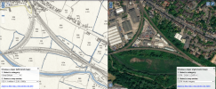
Screengrab of National Library of Scotland map comparison page. 1900 OS map on left, modern satellite imagery on right


Here's a screengrab from the National Library of Scotland map comparison page.
I'm interested in the meaning of S.P. - I understand this means signal post. What did this mean contextually, on a 1900s map?
What were the likely signalling systems in use at the time? What would I see at this point? How comprehensive are these markings? An old forum post suggests signal boxes weren't always accurately marked, but presumably coverage of signal posts was even more patchy.


I'm also surprised to learn there were 2 signal boxes within around 300m of each other!
 
Sponsor Post - registered members do not see these adverts; click here to register, or click here to log in
R

RailUK Forums

John Webb

Established Member
Joined
5 Jun 2010
Messages
3,468
Location
St Albans
S.P. = Signal Post (But the OS did not always get these accurately updated) It simply means a post carrying one or more signal arms. Could also be a bracket signal.

I'm not certain exactly which bit of railway you are looking at, but in the early days of the railways there were limits, originally 150yards, over which mechanical points could be operated - basically 'line of sight'. As signalling improved this limit was gradually raised to 350yards.
But in the case of a triangular junction, such as that on the map, considerations of observing train tail lamps to ensure passing trains were complete whichever route they took also played a part in the siting of signal boxes.
 
Joined
30 Oct 2019
Messages
167
Location
GEML
I see! This is just west of Hythe (Essex) station and overlooks East Gate Junction & box

Looking around the area, the bottom left corner of the triangle appears to be 330 yards away - just within the limit. Presumably this is one of the reasons the curve is so tight here also?

I believe this area housed a port formerly also. Very interesting comparison with today

Thank you
 

Gloster

Established Member
Joined
4 Sep 2020
Messages
10,720
Location
Up the creek
You can’t really tell what block system was in use at that time from a map, but in almost all cases on a double-track line it would have been Absolute; except on a few goods lines with Permissive or No-block arrangements. Single lines would generally have some sort of tablet/token/train staff system. There were exceptions, but they were few. (A very simple explanation.)
 

Railsigns

Established Member
Joined
15 Feb 2010
Messages
2,753
Looking around the area, the bottom left corner of the triangle appears to be 330 yards away - just within the limit. Presumably this is one of the reasons the curve is so tight here also?
Since each corner of the triangle is worked by its own signal box, the limit for mechanical operation of points wouldn't have been a constraint. It would play no part in determining the track alignment.
 

John Webb

Established Member
Joined
5 Jun 2010
Messages
3,468
Location
St Albans
Some further information - the last East Gate junction box was erected in 1924 by the LNER and controlled both that junction and the Colne Junction on the West side of the triangle. Hythe junction box closed in 1958 in the resignalling prior to electrification, and East Gate took over the whole triangle. It was closed in March 2009 when the East Gate workstation at Colchester PSB took over.
 
Joined
30 Oct 2019
Messages
167
Location
GEML
Since each corner of the triangle is worked by its own signal box, the limit for mechanical operation of points wouldn't have been a constraint. It would play no part in determining the track alignment.
I see - hadn't noticed that box
Some further information - the last East Gate junction box was erected in 1924 by the LNER and controlled both that junction and the Colne Junction on the West side of the triangle. Hythe junction box closed in 1958 in the resignalling prior to electrification, and East Gate took over the whole triangle. It was closed in March 2009 when the East Gate workstation at Colchester PSB took over.
Thank you

Although a little off topic, how can you date these maps? They are from the time range 1940-1970 but I can't tell what year exactly - I'm not sure how to do this
 

DelW

Established Member
Joined
15 Jan 2015
Messages
4,739
Although a little off topic, how can you date these maps? They are from the time range 1940-1970 but I can't tell what year exactly - I'm not sure how to do this
On the NLS website, you can choose to look at maps as individual sheets rather than "stitched together" into a seamless layer.

You can then choose to look at map sheets from different dates, which also include the map margins with their original revision information.

It may take a bit of trial and error to find which sheet has been used for the layer in the side by side comparison though.
 

Gloster

Established Member
Joined
4 Sep 2020
Messages
10,720
Location
Up the creek
This is, I think, the 1896 revision, published in 1897. If you go to the option of individual sheets for the 25” (and others), it gives the various options including dates under the thumbnail.

Incidentally, has anyone found the problem that I now have that when I type in a place name in the Search box at top left, it takes the first letter and then stops?
 

etr221

Established Member
Joined
10 Mar 2018
Messages
1,343
On the side-by-side and gereferenced view on the NLS website there is a 'display map details' clickable link, which gives details of the map you're looking (edition, sheet, dates, etc.), and link to go to see the individual sheet. Frequently, what you are seeing is a combination from different scanned sheets.

A point I would make is that OS maps show what the surveyor saw ('on the ground') and noted down, and got through to the published map. Not what the railway thought was there, and actually used...

So for signalling details you will need to search through railway archives if you really want full details.
 
Status
Not open for further replies.

Top