Please Explain
Member
As a regular visitor to le Nord-Pas-de-Calais I pass through the Port fairly regularly.
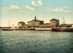
I've always been interested in the cross channel ports and how things were done before the tunnel and specifically Dover Marine and Calais Martime.
The station building is still there, adjacent to berth 5. I believe it is still used by the port as a waiting area for the truckers and has a cafe and toilets inside. This is the only remnant of the gare, as out on the quay the platforms and tracks are now obviously long gone.
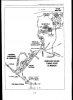
My question is about the track layout which route the line took to reach the Gare de Ville? As the port is now very heavily guarded due to the current issues with the migrants and the site is now enclosed by the perimeter fencing, which must cross the former track bed of the line into le Gare Maritime somewhere.
Does anyone happen to know where this is / was?
Would I be correct in thinking that there must have been a level crossing over Avenue du Commandant Cousteau just south of the current port perimeter fence before the lock / bridge and the line then continued along the quay round towards Calais Ville? Or maybe this road was built after the line closed in the 90's?
There are very few pictures of le Gare Maritime available on the net so as I am not a native of Calais or old enough to remember it is very difficult to tell what the layout was like back then.
Any information, memories or even better if you have any old photographs of the Gare Maritime to share it would be greatly appreciated.
Anyone who has any stories and memories of passing through Calais Maritime and pre channel tunnel days please do share them, I'd love to hear them!
Thanks so much.
I've always been interested in the cross channel ports and how things were done before the tunnel and specifically Dover Marine and Calais Martime.
The station building is still there, adjacent to berth 5. I believe it is still used by the port as a waiting area for the truckers and has a cafe and toilets inside. This is the only remnant of the gare, as out on the quay the platforms and tracks are now obviously long gone.
My question is about the track layout which route the line took to reach the Gare de Ville? As the port is now very heavily guarded due to the current issues with the migrants and the site is now enclosed by the perimeter fencing, which must cross the former track bed of the line into le Gare Maritime somewhere.
Does anyone happen to know where this is / was?
Would I be correct in thinking that there must have been a level crossing over Avenue du Commandant Cousteau just south of the current port perimeter fence before the lock / bridge and the line then continued along the quay round towards Calais Ville? Or maybe this road was built after the line closed in the 90's?
There are very few pictures of le Gare Maritime available on the net so as I am not a native of Calais or old enough to remember it is very difficult to tell what the layout was like back then.
Any information, memories or even better if you have any old photographs of the Gare Maritime to share it would be greatly appreciated.
Anyone who has any stories and memories of passing through Calais Maritime and pre channel tunnel days please do share them, I'd love to hear them!
Thanks so much.
")